MyTopo
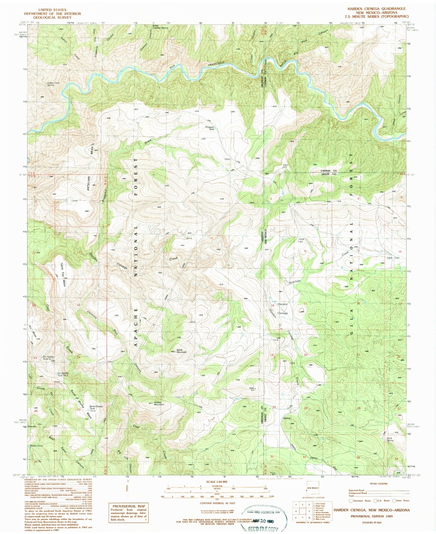
Classic USGS Harden Cienega New Mexico 7.5'x7.5' Topo Map
Couldn't load pickup availability
Historical USGS topographic quad map of Harden Cienega in the states of New Mexico, Arizona. Map scale may vary for some years, but is generally around 1:24,000. Print size is approximately 24" x 27"
This quadrangle is in the following counties: Catron, Grant, Greenlee.
The map contains contour lines, roads, rivers, towns, and lakes. Printed on high-quality waterproof paper with UV fade-resistant inks, and shipped rolled.
Contains the following named places: Antelope Creek, Antelope Mesa, Antelope Mesa Tank Number 2, Antelope Mesa Tank Number One, Antelope Mesa Tank Number Two, Antelope Mesa Tanks Number One and Two, Antelope Well, Arizona Antelope Corral, Baldy Mountain, Bear Up Tank, Bee Tank, Beef Eater Canyon, Big Lue Canyon, Big Pine Canyon, Big Rock Tank, Boiling Mesa Corral, Boiling Mesa Tank, Bottom Tank, Brock Tank, Brown Tank, Burnt Stump Mesa, Burnt Stump Tank, California Tank, Cheblie Tanks, Chimney Rock Canyon, Chimney Rock Tank, Citizen Canyon, Coal Creek Tank, Coalson Canyon, Coalson Tank, Copperas Canyon, Corner Tank, Dave Tank, Dead Buck Tank, Deep Tank Number One, Deep Tank Number Two, Distill Tank, Ditch Tank, Dix Mesa, Dix Saddle Number One Tank, Dix Saddle Number Two Tank, Dock Tank, Duncan Tank, East Baldy Tank, End Mountain Tank, Forest Tank, Garner Tank Number 1, Garner Tank Number 2, Garner Tank Number One, Garner Tank Number Two, Grassy Mountain, Grassy Tank, Hade Springs Tank, Harden Cienega, Holliman Tank, Horse Range Corral, Horse Range Tank, Horse Ridge Corral, Indian Cave Spring, Indian Creek, Jim Tank, Juniper Tank, Keith Tank, Little Lloyd Canyon, Little Prospect Tank, Lloyd Canyon, Lone Pine Tank, Lower Coalson Spring, Lower Coalson Tank, Lower Little Floyd Tank, McDonald Tank Number 1, McDonald Tank Number One, McDonald Tank Number Two, McDonald Tanks Number One and Number Two, Middle Tank, Mule Creek Tank, New Road Tank, North Baldy Corral, North Baldy Tank, North Side Tank, Old SI Tank, Page Corral, Pasture Tank Number One, Pasture Tank Number Two, Pine Tank, Point Tank, Pothole Tank, Prong Tank, Prospect Corral, Prospect Draw, Prospect Mountain Tank, Prospect Tank, Red Tank, Ridge Tank, Rim of River Tank, Rimrock Tank, Rock Spring, Rocky Tank, Rough Tank, Round Mountain Tank, Saddle Tank, School Canyon Tank, SI Flat Tank, SI Mountain Tank, Sixshooter Canyon, Sixshooter Creek, Slate Tank, SOB Tank, Sour Dock Tank, South Baldy Tank, South Side Tank, South Silt Tank, Stateline Tank, Table Top Mesa, Table Top Tank, Tiger Tank, Top of Grassy Tank, Turkey Tank, Two O'Clock Tank, Upper Little Floyd Tank, Ward Tank, West Fork Copperas Canyon, Whitetail Tank, Wild Antelope Tank, Woodruff Tank, WS Paint Tank, WS Point Tank