
MyTopo
Classic USGS Harkers Island North Carolina 7.5'x7.5' Topo Map
Couldn't load pickup availability
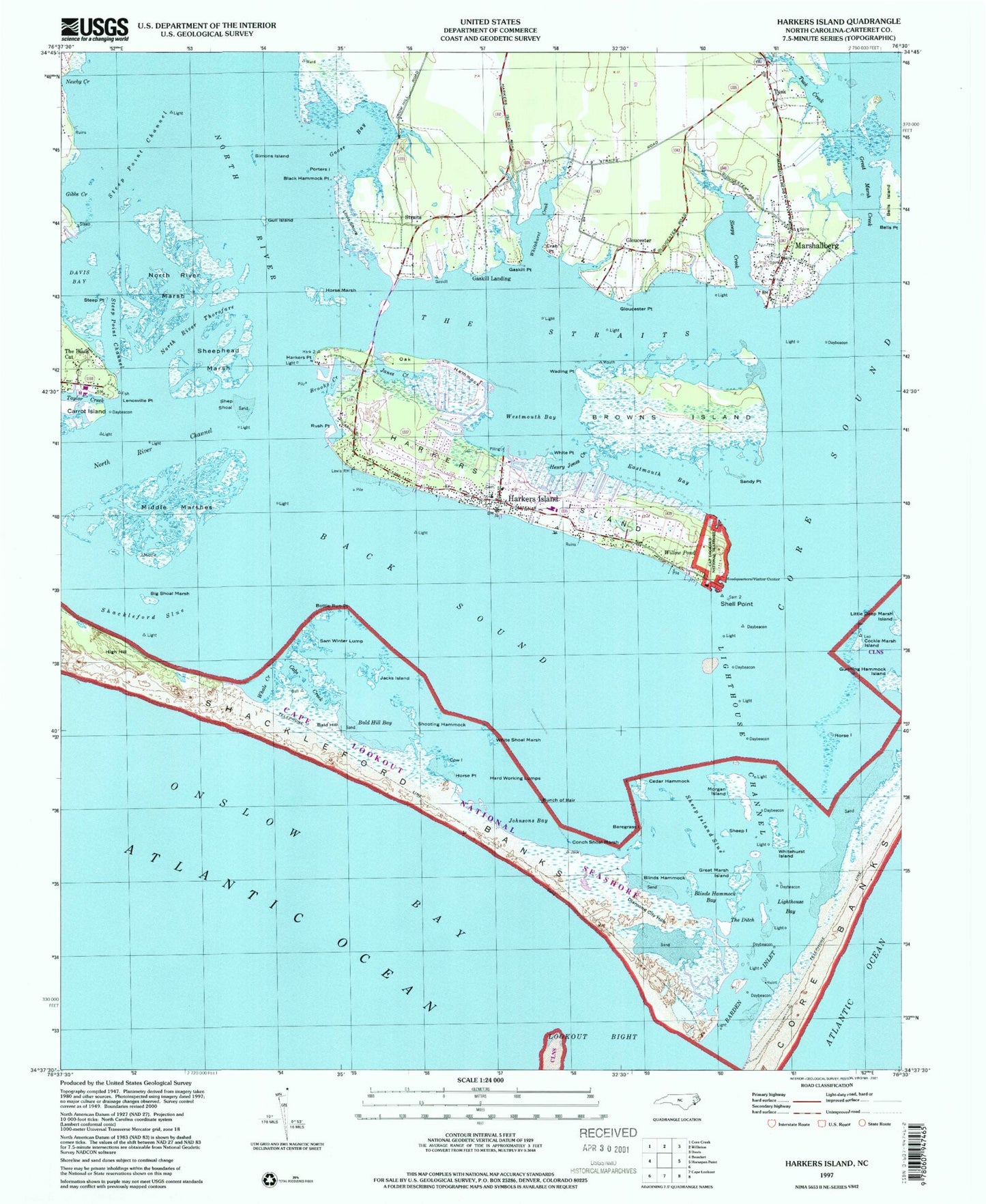
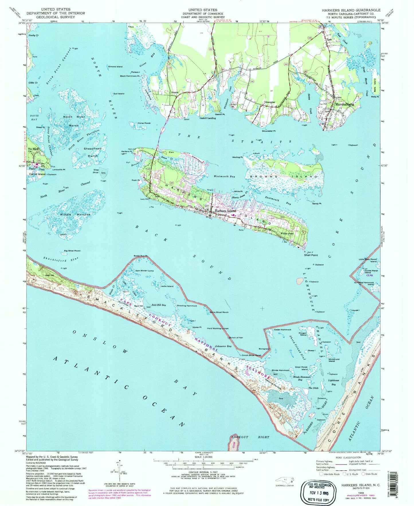
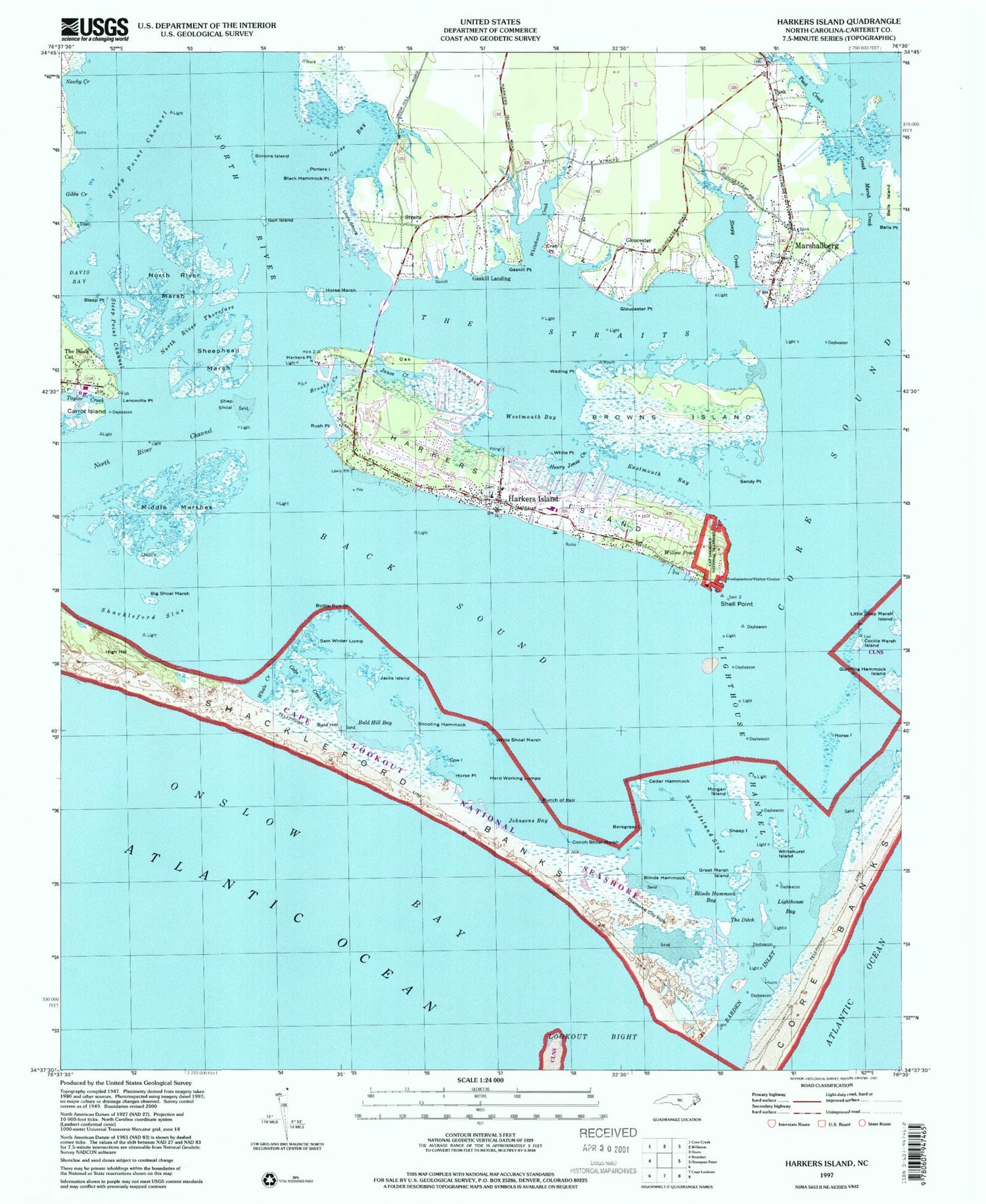
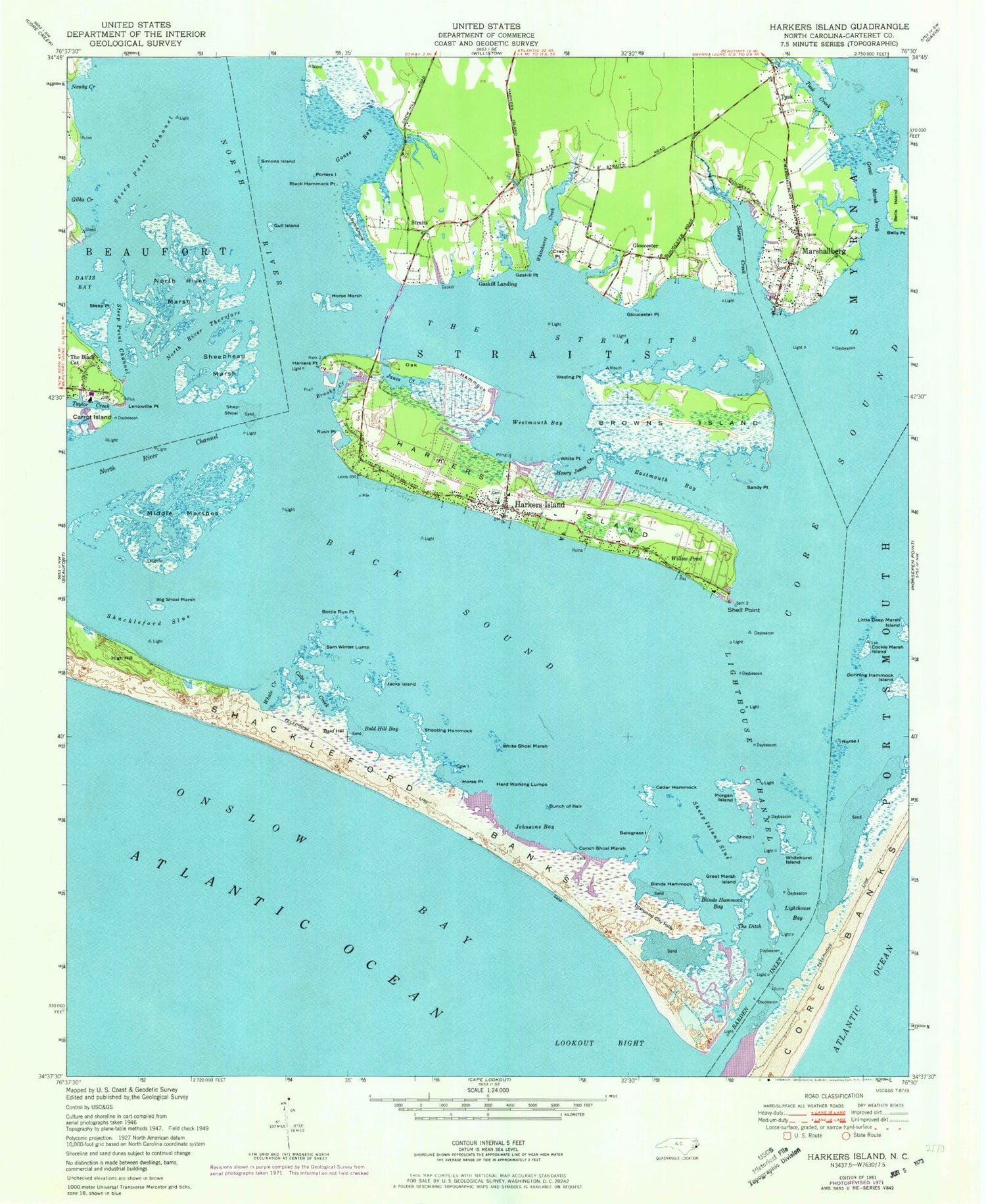
Historical USGS topographic quad map of Harkers Island in the state of North Carolina. Typical map scale is 1:24,000, but may vary for certain years, if available. Print size: 24" x 27"
This quadrangle is in the following counties: Carteret.
The map contains contour lines, roads, rivers, towns, and lakes. Printed on high-quality waterproof paper with UV fade-resistant inks, and shipped rolled.
Contains the following named places: Back Sound, Bald Hill Bay, Baregrass Island, Big Shoal Marsh, Black Hammock Point, Blinds Hammock, Blinds Hammock Bay, Bottle Run Point, Brooks Creek, Browns Island, Bunch of Hair, Cabs Creek, Cedar Hammock, Cockle Marsh Island, Conch Shoal Marsh, Cow Island, Crab Point, Davis Bay, Eastmouth Bay, Gaskill Point, Gloucester Point, Goose Bay, Great Marsh Creek, Great Marsh Island, Gull Island, Gunning Hammock Island, Hard Working Lumps, Harkers Island, Harkers Point, Henry Jones Creek, Horse Island, Horse Marsh, Horse Point, Jacks Island, Janes Creek, Johnsons Bay, Lenoxville Point, Lighthouse Bay, Lighthouse Channel, Little Deep Marsh Island, Lovis Shore, Marshallberg, Middle Marshes, Morgan Island, Newby Creek, North River Channel, North River Marsh, North River Thorofare, Oak Hammock, Porters Island, Rush Point, Sam Winter Lump, Sandy Point, Shackleford Banks, Shackleford Slue, Sheep Island, Sheep Island Slue, Sheephead Marsh, Shell Point, Shep Shoal, Shooting Hammock, Simons Island, Sleepy Creek, Steep Point, Steep Point Channel, Steep Point Channel, Straits, The Ditch, The Straits, Tusk Creek, Wading Point, Westmouth Bay, Whale Creek, White Point, White Shoal Marsh, Whitehurst Creek, Whitehurst Island, Willow Pond, Harkers Island School, Straits Haven, Sam Winsors Lump, Barden Inlet, North River, Bald Hill, Barden Inlet, Bells Island, Diamond City Hills, Gaskill Landing, Gloucester, Harkers Island, High Hill, The Black Cat, Tusk, Township of Harkers Island, Township of Marshallberg, Crystal Coast, Harkers Island Census Designated Place, Refuge Fellowship Church, L R Rose Marina and Boatworks, Island Road Baptist Church, Straits United Methodist Church, Gloucester Census Designated Place, Marshallberg Census Designated Place, Harkers Island Fire and Rescue Squad, Marshallberg Volunteer Fire Department, Gloucester Post Office, Marshallberg Post Office, Harkers Island Post Office, Victoria Cemetery, Back Sound, Bald Hill Bay, Baregrass Island, Big Shoal Marsh, Black Hammock Point, Blinds Hammock, Blinds Hammock Bay, Bottle Run Point, Brooks Creek, Browns Island, Bunch of Hair, Cabs Creek, Cedar Hammock, Cockle Marsh Island, Conch Shoal Marsh, Cow Island, Crab Point, Davis Bay, Eastmouth Bay, Gaskill Point, Gloucester Point, Goose Bay, Great Marsh Creek, Great Marsh Island, Gull Island, Gunning Hammock Island, Hard Working Lumps, Harkers Island, Harkers Point, Henry Jones Creek, Horse Island, Horse Marsh, Horse Point, Jacks Island, Janes Creek, Johnsons Bay, Lenoxville Point, Lighthouse Bay, Lighthouse Channel, Little Deep Marsh Island, Lovis Shore, Marshallberg, Middle Marshes, Morgan Island, Newby Creek, North River Channel, North River Marsh, North River Thorofare, Oak Hammock, Porters Island, Rush Point, Sam Winter Lump, Sandy Point, Shackleford Banks, Shackleford Slue, Sheep Island, Sheep Island Slue, Sheephead Marsh, Shell Point, Shep Shoal, Shooting Hammock, Simons Island, Sleepy Creek, Steep Point, Steep Point Channel, Steep Point Channel, Straits, The Ditch, The Straits, Tusk Creek, Wading Point, Westmouth Bay, Whale Creek, White Point, White Shoal Marsh, Whitehurst Creek, Whitehurst Island, Willow Pond, Harkers Island School, Straits Haven, Sam Winsors Lump, Barden Inlet, North River, Bald Hill, Barden Inlet, Bells Island, Diamond City Hills, Gaskill Landing, Gloucester, Harkers Island, High Hill, The Black Cat, Tusk, Township of Harkers Island, Township of Marshallberg, Crystal Coast, Harkers Island Census Designated Place, Refuge Fellowship Church, L R Rose Marina and Boatworks, Island Road Baptist Church, Straits United Methodist Church, Gloucester Census Designated Place, Marshallberg Census Designated Place, Harkers Island Fire and Rescue Squad, Marshallberg Volunteer Fire Department, Gloucester Post Office, Marshallberg Post Office, Harkers Island Post Office, Victoria Cemetery