

MyTopo
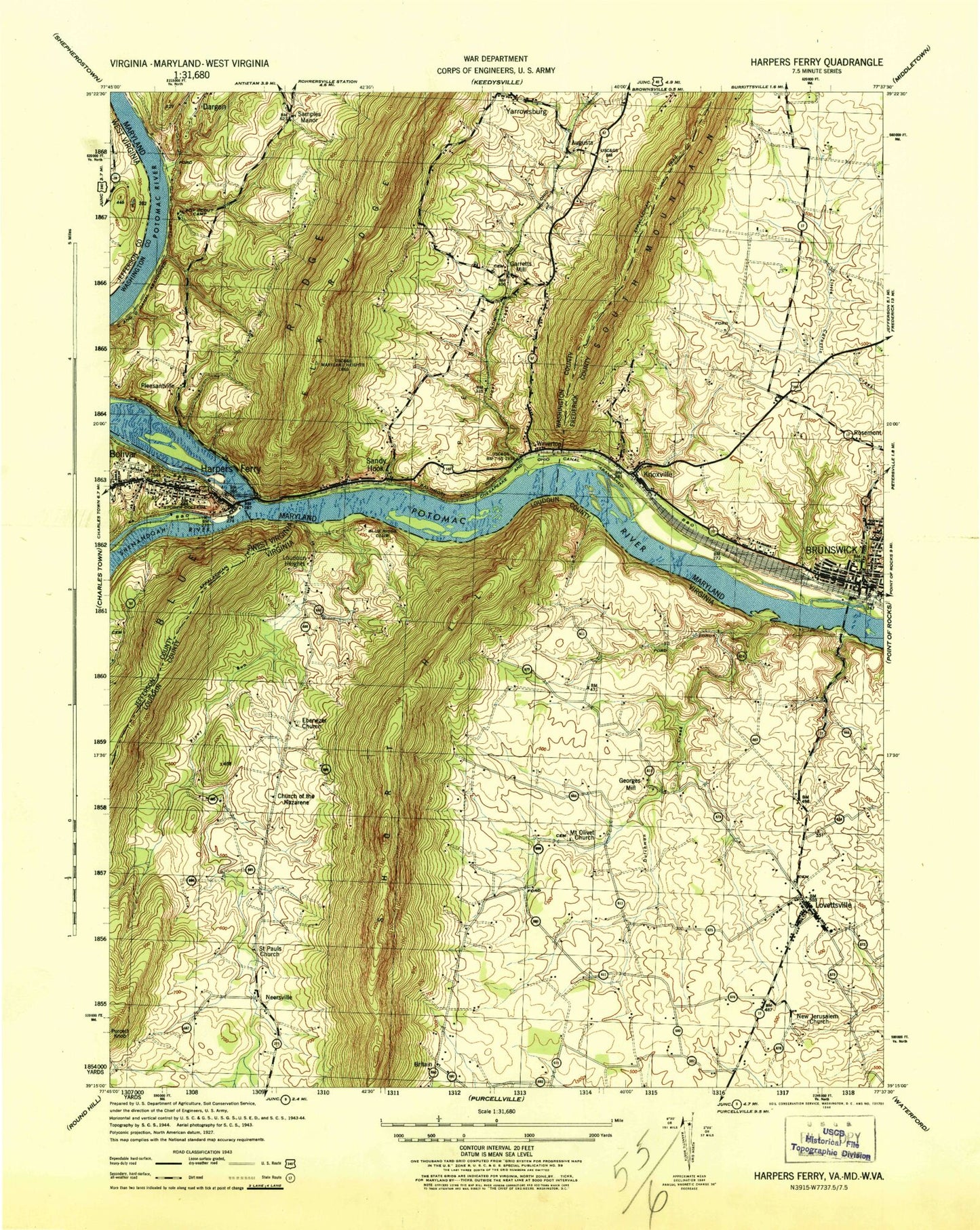
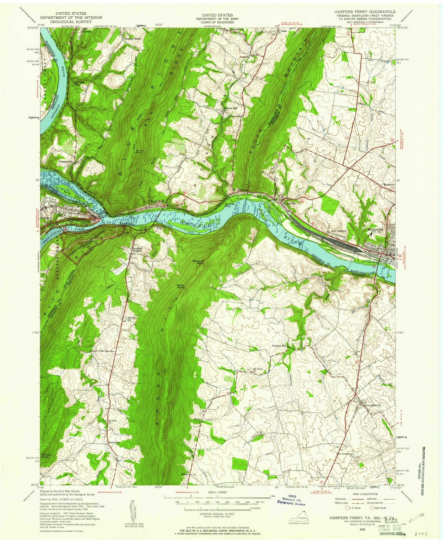
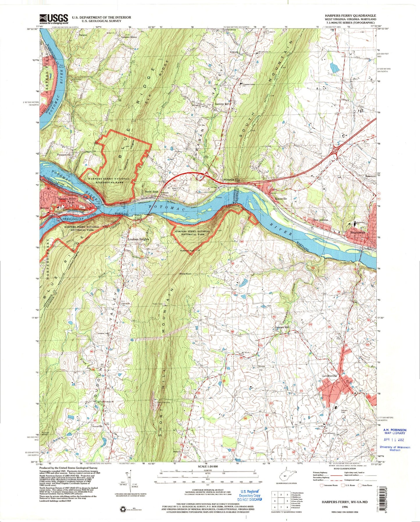
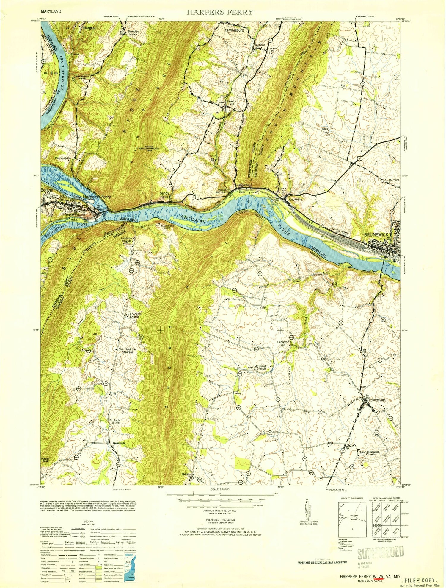
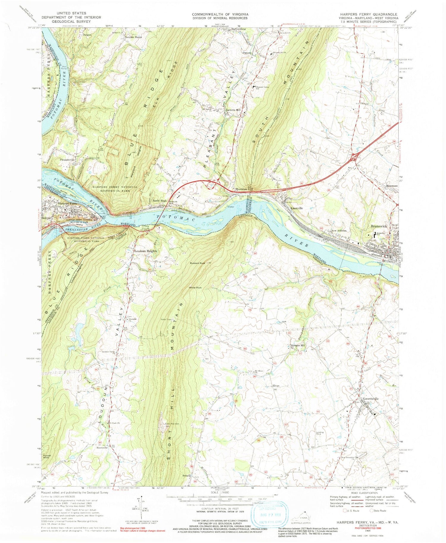
USGS Classic Harpers Ferry West Virginia 7.5'x7.5' Topo Map
Couldn't load pickup availability
Historical USGS topographic quad map of Harpers Ferryin the states of West Virginia, Maryland, Virginia. Scale: 1:31680. Print size: 24" x 27"
This quadrangle is in the following counties: Frederick, Jefferson, Loudoun, Washington.
The map contains contour lines, roads, rivers, towns, lakes, and grids including latitude / longitude and UTM / MGRS. Printed on high-quality waterproof paper with UV fade-resistant inks.
Contains the following named places: Loudoun Heights, Harpers Ferry National Historical Park, Loudoun Heights Trail, Potomack Canal, Shenandoah River, Virginius Island, Harpers Ferry, Marist College Camp Spring, Walker Spring, Klein Spring, Warner Spring, Barr Spring, Baltimore and Ohio Railroad Covered Bridge, White Horse Rapids, Winchester and Potomac Railroad Bridge, Arsenal Square, Camp Hill, Curtis Freewill Baptist Church, Free Church (historical), Hall Island (historical), Halls Rifle Works (historical), Harper Cemetery, Harpers Ferry Historic District, Herrs Dam (historical), Herrs Island (historical), Herrs Mill (historical), Jefferson Rock, John Brown Monument, John Browns Fort (historical), Lower Town, The Point, Potomac Ferry (historical), Lake Quigley (historical), Saint Johns Episcopal Church (historical), Saint Peters Roman Catholic Church, Saint Peters School (historical), Shenandoah Bridge (historical), Storer College (historical), The Staircase, United States Armory and Arsenal at Harpers Ferry (historical), Virginius (historical), Wernwags Sawmill (historical), Town of Harpers Ferry, Friendship Fire Company, Harpers Ferry Bridge, Harpers Ferry Police Department, Harpers Ferry Post Office, Bethel United Methodist Church, Brownsville Brethren Church, Brunswick Elementary School, Byrnes Island, Israel Creek, Knoxville, Manidokan Camp, Mount Moriah Church, Pleasant Valley, Pleasant Valley Elementary School, Saint Lukes Church, Samples Manor, Garretts Mill, Pleasantville, Augusta, Maryland Heights, New Addition, Sandy Hook, Weverton, Yarrowsburg, Damazo Pond Dam, Damazo Pond, Brunswick, Dutchman Creek, Harpers Ferry National Historical Park, Bethany Lutheran Church, Brunswick Heights Park, Brunswick Museum, Brunswick Post Office, Brunswick Town Hall, Colonial Island, Faith Assembly of God Church, First Baptist Church, Hobo Jungle (historical), Lock 30, Maplecrest Farm, Old Lutheran Cemetery, Old Reformed Cemetery, Pine Hill Estates, Rice, Roelkeys Knoll, Saint Francis of Assisi Roman Catholic Church, Dargan Quarry, Baltimore and Ohio Railroad Covered Bridge, Samples Manor Cemetery, Brownsville Heights Cemetery, Dargan Bend Picnic Area, Elgin School (historical), Harpers Ferry Farm, Lock 31, Lock 32, Lock 33, Lock 34, Long Canal (historical), Loughridge Mill (historical), Mount Moriah Baptist Church Cemetery, Saint Lukes Episcopal Church Cemetery, Stone Fort (historical), Stonebraker (historical), Water Acres, Weverton Camp (historical), Weverton Cliffs, Weverton First Baptist Church, White Horse Rapids, Winchester and Potomac Railroad Bridge, Potomac Ferry (historical), District 11 Sandy Hook, Brunswick Fire Company Station 5, Potomac Valley Fire Department Company 11, Brunswick Police Department, Brunswick Volunteer Ambulance and Rescue Company Station 19, City of Brunswick, Garretts Mill Census Designated Place, Sandy Hook Census Designated Place, Potomac Wayside, Buzzard Rock, Dutchman Creek, Ebenezer United Methodist Church, Loudoun Valley, Lovettsville Union Cemetery, Mount Olivet United Methodist Church, New Jerusalem Church, Piney Run, Saint Pauls Church, Lowry Dam, Lowry Lake, Purcell Knob, Britain, Elvan, Georges Mill, Loudoun Heights, Loudoun Heights, Lovettsville, Neersville, White Rock, Lovettsville Airport, The Grass Patch Airport, Short Hill Mountain, Harpers Ferry National Historical Park, Shenandoah River, White Horse Rapids, Afgan Church, Harpers Ferry Adventure Center, Bolington, Ebenezer United Methodist Cemetery, Everharts Mill, Keister, Lovettsville Library, Lovettsville Post Office, Mount Olivet United Methodist Cemetery, Old Lovettsville Cemetery, Old Salem Church (historical), Pomona, Providence Primitive Baptist Church (historical), Saint James Reformed Cemetery, Saint James United Church of Christ, Springdale, Waters School (historical), Woodland School (historical), Lovettsville Elementary School, Nell Boone Park, African Methodist Episcopal Cemetery, Lovettsville Volunteer Fire and Rescue Company 12, Loudoun County Fire Department and Rescue - Neersville Volunteer Fire and Rescue Company 16, Lovettsville Community Center, Lovettsville Park, Town of Lovettsville, Between The Hills Community Center, Catoctin Bible Church, Lovettsville Game Protective Association Dam, Lovettsville Historical Society & Museum, Lovettsville Town Hall, Saint Pauls Lutheran Church Cemetery