MyTopo
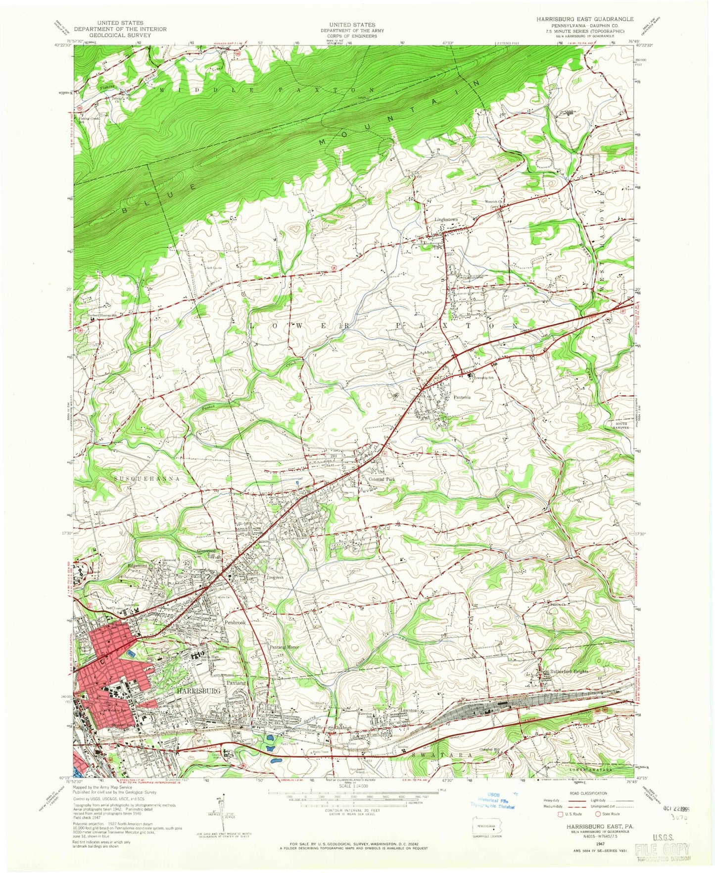
Classic USGS Harrisburg East Pennsylvania 7.5'x7.5' Topo Map
Couldn't load pickup availability
Historical USGS topographic quad map of Harrisburg East in the state of Pennsylvania. Typical map scale is 1:24,000, but may vary for certain years, if available. Print size: 24" x 27"
This quadrangle is in the following counties: Dauphin.
The map contains contour lines, roads, rivers, towns, and lakes. Printed on high-quality waterproof paper with UV fade-resistant inks, and shipped rolled.
Contains the following named places: Beth El Cemetery, Bible Church, Blue Ridge Memorial Gardens, Calvary Cemetery, Calvary Independent Church, Central Dauphin East High School, Central Dauphin East Junior High School, Central Dauphin High School, Chambers Hill School, Christ Church, Christ the Saviour Church, Colonial Country Club, Colonial Park, Colonial Park Church, Darlington Trail, East Harrisburg Cemetery, Edgemont, Edison Junior High School, Faith Church, Faith United Church, Foose School, Foursquare Church, Glenwood, Glenwood School, Grace Church, Harrisburg High School John Harris Campus, Harrisburg Cemetery, Harrisburg Christian School, Holy Cross Cemetery, Harrisburg Catholic Elementary School Holy Family Campus, Holy Name of Jesus Church, Herbert Hoover Elementary School, Koons Memorial Park, Lawnton, Lincoln School, Linglestown, Lower Paxton Junior High School, Marshall Math and Science Academy, Melrose School, Mount Moriah Cemetery, Mount View School, North Side School, Oakleigh, Paxtang, Paxtang Cemetery, Paxton Church, Paxton Church, Paxtonia, Paxtonia School, Penbrook, Phillips School, Progress, Prospect Hill Cemetery, Reservoir Park, Rutherford Heights, Rutherford Yards, Saint Marks Church, Saint Thomas Church, Shimmell School, Shoop's Cemetery Garden of Rest, Shoops Cemetery, South Side School, State Game Lands Number 246, Trinity Church, Webster School, Willow Grove Cemetery, Woodlawn Memorial Gardens, Woodward School, State Police Area Three Airport, The Point Shopping Center, Vernon School, Paxtang Manor, Mount Lou-San Bible School, Harrisburg Sportsman Club, Fishing Creek School, Scottsdale Plaza, WHPF-FM (Harrisburg), WITF-FM (Harrisburg), WHPT-TV (Harrisburg), WITF-TV (Harrisburg), WGGF-TV (Lebanon), Devonshire Heights, Mountain View, Blue Ridge Manor, Rockford Heights, Eubuna Gardens, Colonial Terrace, Lawrence Park, Sangree, Mountain View Acres, Holiday Park, Houck Manor, Colonial Crest, Colonial Hills, Old Colonial Village, Rustic Hills, Haven Croft, Fox Chase, Sunset Manor, Ridge Acres, Forest Hills, Centennial Acres, Brandywine Manor, Woodridge Estates, Club Estates, Hanover Heights, Twin Lakes Park, Paxton Acres, Springford Village, Marene Village, Kent Gardens, Poplar Gardens, David Manor, Locust Lane Acres, Pennwood, Paxton Hollow Estates, Colonial Estates, Locust Lane Gardens, South Devonshire Estates, Devonshire Estates, Devonshire Hills, Vaughn, Belmont Acres, Lakeview Heights, Clearview Manor, Holmstead Manor, Sparton Marshfield, Susquehanna Manor, Beaver Brook Manor, Windsor Manor, Colonial Wood, Chestnut Hill, English Manor, Lawnford Acres, Chartwood, Hodges Heights, Lawton Gardens, Bonneymeade Farm, Hassler Meadows, Spring Valley, Bloomburg Village, Catalina, Locust Ridge Manor, Colonial Park Farms, Ridgeview Brightbill Park, Blue Mountain Lions Park, Hocker Park, Blue Ridge Park, Little Valley Park, Hodges Heights Park, Kohl Memorial Park, Putnam Park, Clover Heights Park, Penbrook Park, Royal Terrace Park, Sunshine Park, Bloom Outpatient Clinic, Shipoke Park, Reservoir Park Overlook, Colonial Park Mall, East Park Shopping Center, Kings Plaza, Kline Village Shopping Center, Village of Oakhurst Shopping Center, Harrisburg East Mall, City Line Shopping Center, Hills Shopping Center, Susquehanna Township Middle School, Susquehanna Township High School, Dauphin County Area Vocational Technical School, Linglestown Elementary School, Linglestown Junior High School, Pleasant Hills, Rutherford Gardens, Twin Lakes, Ridgeview, Paxtang Manor, Blue Ridge Country Club, CNB Heliport, State Police Area III Heliport, DBS Heliport, Sara Lindemuth Elementary School, Union Square, Dauphin Plaza, Borough of Paxtang, Borough of Penbrook, Township of Lower Paxton, Township of Susquehanna, Slotznick Run, Rutherford, Black Run, Boyd Big Tree Preserve Conservation Area, Colonial Park Census Designated Place, Paxtonia Census Designated Place, Progress Census Designated Place, Rutherford Census Designated Place, Lawnton Census Designated Place, Linglestown Census Designated Place, Progress Fire Company Station 32, Paxtang Fire Company Station 40, Citizens Fire Company of Penbrook Station 30, Linglestown Fire Company Station 35, Rutherford Fire Company 1 Station 45, Harrisburg Bureau of Fire Station Number 2, Edgemont Volunteer Fire Station 31, Lawnton Fire Company Station 44, Chambers Hill Fire Company and Community Association Station 546, Paxtonia Fire Company Station 34, Harrisburg Bureau of Fire Station 8 Mount Pleasant, Colonial Park Fire Company 1, Susquehanna Township Emergency Medical Services Station 9, Paxtang Borough Police Department, Penbrook Police Department, Susquehanna Township Police Department, Lower Paxton Township Police Department, Dauphin County Prison, Swatara Post Office, Lower Paxton Post Office, Temple Ohev Sholom Cemetery, Wenrichs Cemetery, Charlton United Methodist Church Cemetery, Gaynor Lane Cemetery, Stroh's Cemetery, Paxton Church Road Cemetery, Paxton Presbyterian Churchyard, Colonial Park United Church Memorial Garden, Workmans Circle Cemetery, Lincoln Cemetery, Paxton Church of the Brethren Cemetery, Linglestown Church of God Cemetery, Raysors Cemetery, Kesher Israel Cemetery, Chisuk Emuna Cemetery, Saint Andrews in the Valley Church Columbarium, Chambers Hill Cemetery, Beth El Cemetery


