MyTopo
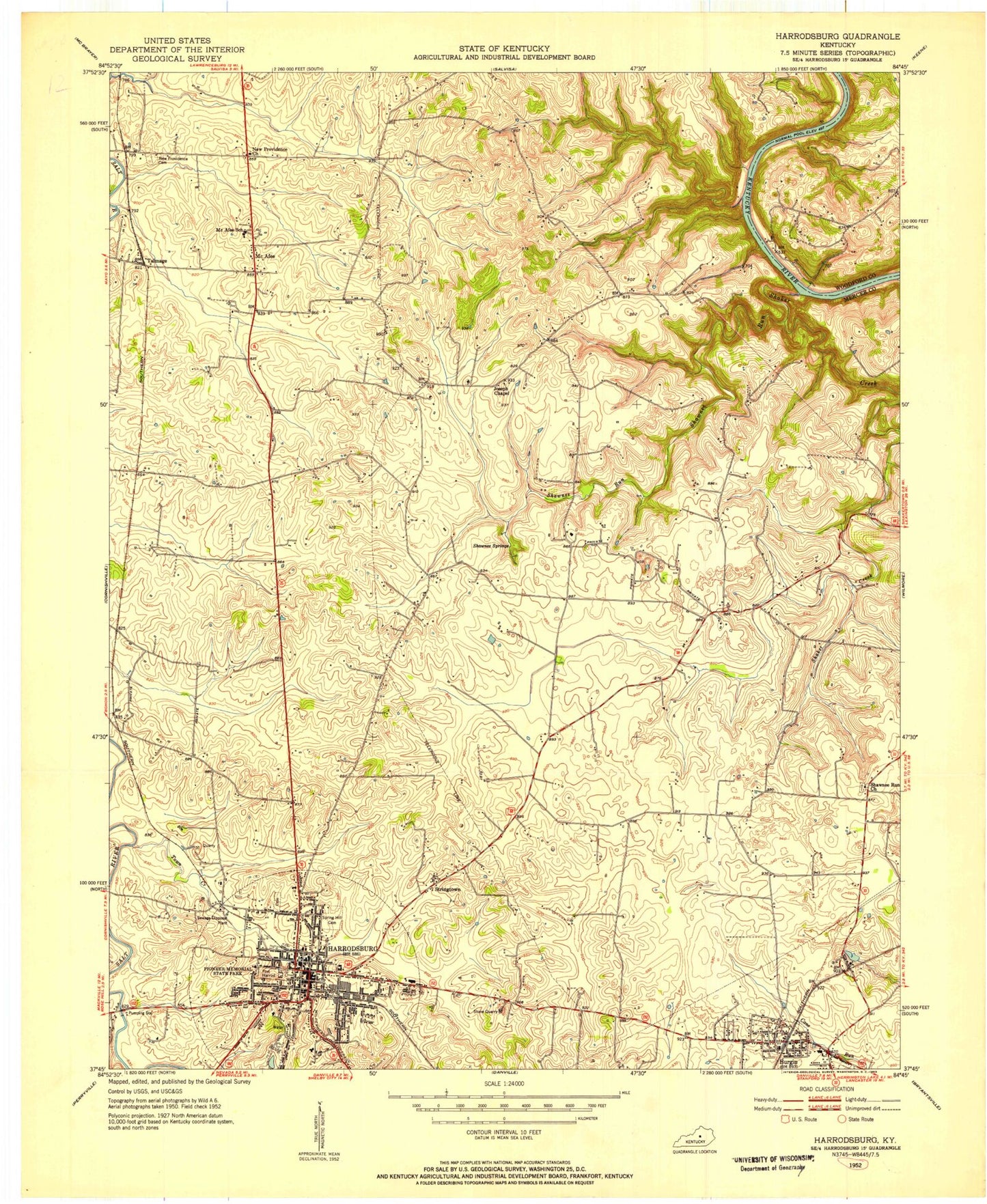
Classic USGS Harrodsburg Kentucky 7.5'x7.5' Topo Map
Couldn't load pickup availability
Historical USGS topographic quad map of Harrodsburg in the state of Kentucky. Typical map scale is 1:24,000, but may vary for certain years, if available. Print size: 24" x 27"
This quadrangle is in the following counties: Mercer, Woodford.
The map contains contour lines, roads, rivers, towns, and lakes. Printed on high-quality waterproof paper with UV fade-resistant inks, and shipped rolled.
Contains the following named places: Burgin, Harrodsburg, Joseph Chapel Methodist Church, Judd Siding, Kissing Bridge, McAfee, McAfee School, New Providence Cemetery, New Providence Church, Old Fort Harrod State Park, Riverview Estates, Salt River Park, Shaker Creek, Shakertown Church, Shawnee Run, Shawnee Run Baptist Church, Shawnee Run Spring, Shawnee Springs, Spring Hill Cemetery, Talmage, Town Creek, Unity Church, Young Park, Braxton, Jackson, Mundys Landing, Stringtown, Mercer County, City of Harrodsburg, City of Burgin, National Guard Armory Harrodsburg, Mundys Ferry (historical), Mundys Landing Post Office (historical), Mundys Ferry (historical), Braxton Baptist Church (historical), Braxton Post Office (historical), Brewers Mill (historical), Burgin Railroad Station (historical), Cane Hurst (historical), Cane Run Post Office (historical), Curry (historical), Curry Railroad Station (historical), Dunnlora (historical), East Fork Town Creek, Fairview (historical), Fountaine Bleau, Maple Lawn (historical), McAfee Post Office (historical), McAfee Railroad Station (historical), McAfee Station (historical), McGary Station (historical), Mercer County Fairgrounds, Moores School (historical), Shawnee Run (historical), Talmage Post Office (historical), The Big Spring, Woodlawn (historical), Harrodsburg-Mercer County Airport (historical), Jackson Railroad Station (historical), Burgin Fire Department, Harrodsburg Fire Department, Mercer Central Fire Department, Mercer County Fire Protection District Station 12 McAfee, Mercer County Fire Protection District Station 6 Burgin Storage, James B Haggin Memorial Hospital, Burgin Independent Schools, Mercer County Emergency Medical Services, Harrodsburg Police Department, Mercer County Sheriff's Office, Burgin Police Department, Burgin Post Office, Harrodsburg Post Office, Burgin, Harrodsburg, Joseph Chapel Methodist Church, Judd Siding, Kissing Bridge, McAfee, McAfee School, New Providence Cemetery, New Providence Church, Old Fort Harrod State Park, Riverview Estates, Salt River Park, Shaker Creek, Shakertown Church, Shawnee Run, Shawnee Run Baptist Church, Shawnee Run Spring, Shawnee Springs, Spring Hill Cemetery, Talmage, Town Creek, Unity Church, Young Park, Braxton, Jackson, Mundys Landing, Stringtown, Mercer County, City of Harrodsburg, City of Burgin, National Guard Armory Harrodsburg, Mundys Ferry (historical), Mundys Landing Post Office (historical), Mundys Ferry (historical), Braxton Baptist Church (historical), Braxton Post Office (historical), Brewers Mill (historical), Burgin Railroad Station (historical), Cane Hurst (historical), Cane Run Post Office (historical), Curry (historical), Curry Railroad Station (historical), Dunnlora (historical), East Fork Town Creek, Fairview (historical), Fountaine Bleau, Maple Lawn (historical), McAfee Post Office (historical), McAfee Railroad Station (historical), McAfee Station (historical), McGary Station (historical), Mercer County Fairgrounds, Moores School (historical), Shawnee Run (historical), Talmage Post Office (historical), The Big Spring, Woodlawn (historical), Harrodsburg-Mercer County Airport (historical), Jackson Railroad Station (historical), Burgin Fire Department, Harrodsburg Fire Department, Mercer Central Fire Department, Mercer County Fire Protection District Station 12 McAfee, Mercer County Fire Protection District Station 6 Burgin Storage, James B Haggin Memorial Hospital, Burgin Independent Schools, Mercer County Emergency Medical Services, Harrodsburg Police Department, Mercer County Sheriff's Office, Burgin Police Department, Burgin Post Office, Harrodsburg Post Office