MyTopo
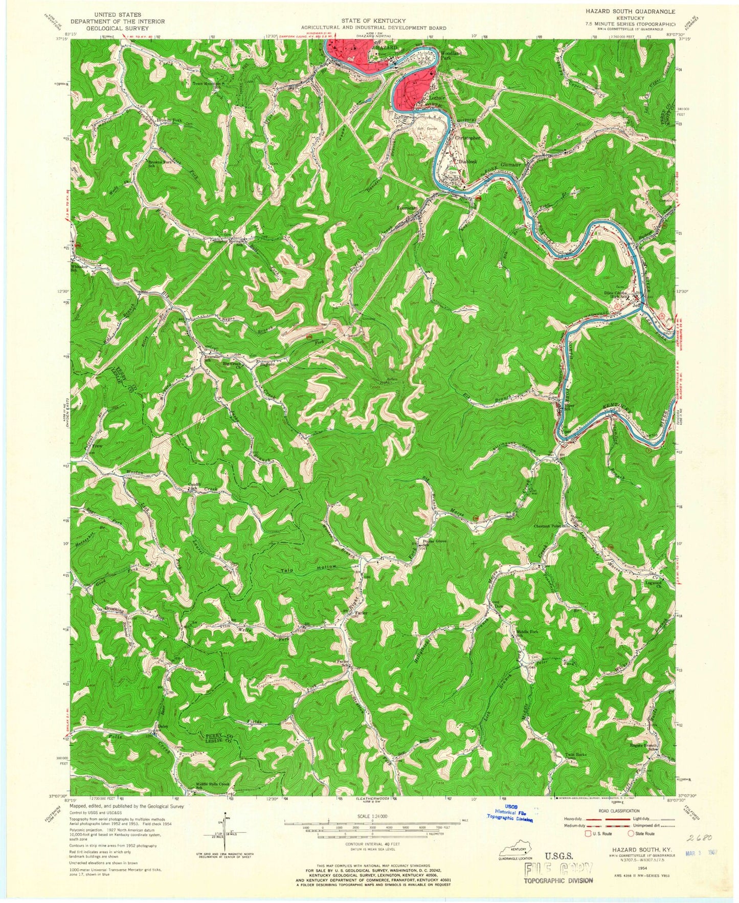
Classic USGS Hazard South Kentucky 7.5'x7.5' Topo Map
Couldn't load pickup availability
Historical USGS topographic quad map of Hazard South in the state of Kentucky. Map scale may vary for some years, but is generally around 1:24,000. Print size is approximately 24" x 27"
This quadrangle is in the following counties: Knott, Leslie, Perry.
The map contains contour lines, roads, rivers, towns, and lakes. Printed on high-quality waterproof paper with UV fade-resistant inks, and shipped rolled.
Contains the following named places: Bailey Branch, Bear Branch, Bens Branch, Big Branch, Big Creek Church, Big Rock Hollow, Browns Fork, Browns Fork Post Office, Browns Fork School, Buckeye Creek, Buffalo Church, Buffalo Creek, Buffalo Fork, Buffen Railroad Station, Bull Fork, Calvary Bible Church, Campbell Branch, Candy Coal Mine, Candy Coal Railroad Station, Carr Fork, Caudill Cemetery, Chestnut Point School, Christopher, Christopher Post Office, Curly Fork, Daley, Daley Post Office, Davidson Branch, Diablock, Diablock Census Designated Place, Diablock Post Office, Dilce Combs High School, Dow, Dow Post Office, Downtown Hazard Post Office, ECCO Coal Mine, Edjouet Railroad Station, Elk Branch, Elm Lick Fork, Engle Branch, Englewood Cemetery, Eversole, Eversole School Number Eleven, Fairview Chapel, Farler, Farler Post Office, Fields Fork, Four Seam Branch, Fourseam, Fourseam Church, Frew, Frew Post Office, Garman Branch, Glomawr, Glomawr Post Office, Glomawr Railroad Station, Good Fork, Gregory Branch, Hamdin Railroad Station, Happy Hollow, Hazard, Hazard City Hall, Hazard Community College, Hazard Fire Department, Hazard High School, Hazard Police Department, Hollythicket Branch, International Bible Church, Ira Combs Memorial Church, Jacks Branch, Jeff, Jeff Census Designated Place, Jeff Missionary Church, Jeff Post Office, Karles Railroad Station, Katy Railroad Station, Kentucky Division of Forestry Kentucky River District, Kirby Post Office, Laurel Fork, Left Fork Maces Creek, Lick Branch, Lick Fork, Logwood Church, Lone Pine Church, Lothair, Lothair Church, Lothair Railroad Station, Maces Creek, Messer Branch, Middle Fork, Middle Fork Church, Middle Fork Maces Creek, Middle Fork School, Middle Poll Creek School, Minyard Branch, Negro Branch, Perry County, Perry County Sheriff's Office, Peter Fork, Plumford Branch, Polecat Branch, Poplar Grove Church, Poundmill Branch, Poundmill Church, Raccoon Creek, Richcoal Branch, Right Fork Buffalo Fork, Right Fork Maces Creek, Riley Branch, Rodgers School, Rogers Branch, Saw Branch, School Number Four, Sheep Hollow, Sovereign Grace Church, Stillhouse Hollow, Storm King Post Office, Stratton Fork, Sulphur Springs School, Tackett Creek, Talp Hollow, Tana Post Office, Town Mountain Baptist Church, Town Mountain School, Twin Rocks Camp, Viper, Viper Division, Viper Fire and Rescue, Viper Post Office, Viper School, WEKH-FM (Hazard), Wells Fork, Whitaker Church, Whitaker Fork, Whitaker School, WJMD-FM (Hazard), WKHA-TV (Hazard), WKHA-TV Tower, WKIC Radio Tower, WKIC-AM (Hazard), Wolf Branch, Wolf Fork, Woodland Park, Wooly Fork, Wooton Branch, WSGS-FM (Hazard), WYMT-TV (Hazard), ZIP Codes: 41751, 41774