MyTopo
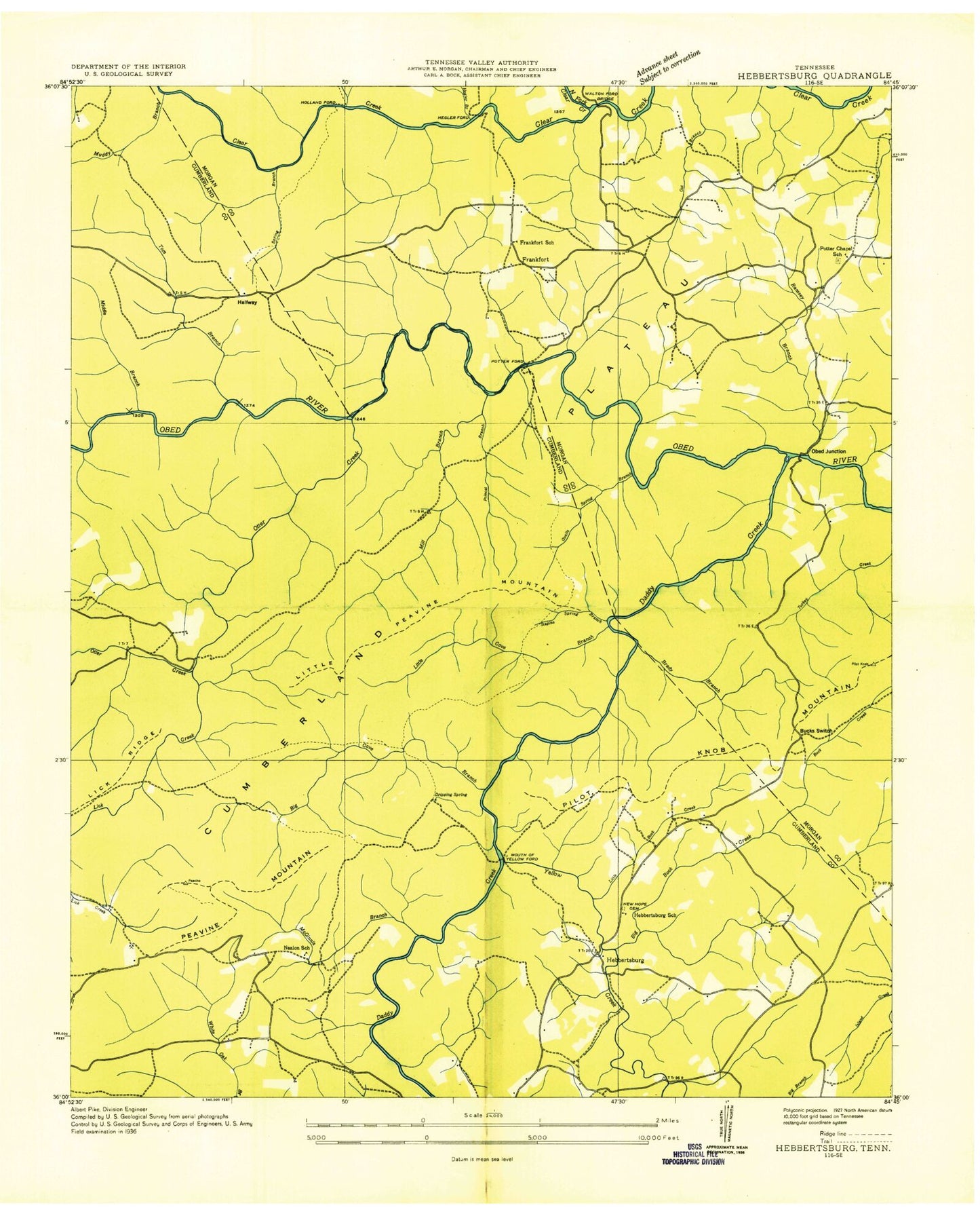
Classic USGS Hebbertsburg Tennessee 7.5'x7.5' Topo Map
Couldn't load pickup availability
Historical USGS topographic quad map of Hebbertsburg in the state of Tennessee. Typical map scale is 1:24,000, but may vary for certain years, if available. Print size: 24" x 27"
This quadrangle is in the following counties: Cumberland, Morgan.
The map contains contour lines, roads, rivers, towns, and lakes. Printed on high-quality waterproof paper with UV fade-resistant inks, and shipped rolled.
Contains the following named places: Staples Spring Branch, Tom Branch, Yellow Creek, Brady Branch, Buck Switch, Cline School, Davis Branch, Dripping Spring, Frankfort School, Grandaddy Branch, Hawn Branch, Hawn Ridge, Hawn Spring Branch, Hegler Branch, Lick Creek, Little Buck Creek, Little Cove Branch, Little Peavine Mountain, Long Branch, McGinnis Branch, Middle Branch, Mill Branch, Mill Creek Branch, Mouth of Yellow Creek Ford, Muddy Branch, New Home Church, Otter Creek, Peavine Mountain, Pilot Knob, Pilot Knob Mountain, Pole Pen Branch, Polecat Branch, Qualls Spring Branch, Ramsey Creek, Rogers Creek, Berkshire Forest, Nealon School (historical), Waltman Ford Bridge, White Creek, Buck Creek, Cove Branch, Daddys Creek, Potter Chapel School, Devils Breakfast Table, Double Drop Falls, Obed Wild and Scenic River, Potter Chapel, Waltman Ford, Frankfort, Halfway, Hebbertsburg, Hegler Ford, Holland Ford, Obed Junction, Potter Ford, Sims Cemetery, New Home Cemetery, New Home School (historical), Watson Cemetery, Hamby Cemetery, Hebbertsburg Cemetery, Frankfort Cemetery, Potters Chapel Cemetery, Hebbertsburg Post Office (historical), Fairfield Glade Census Designated Place, Commissioner District 9, Fairfield Glade Fire Department Station 2, Staples Spring Branch, Tom Branch, Yellow Creek, Brady Branch, Buck Switch, Cline School, Davis Branch, Dripping Spring, Frankfort School, Grandaddy Branch, Hawn Branch, Hawn Ridge, Hawn Spring Branch, Hegler Branch, Lick Creek, Little Buck Creek, Little Cove Branch, Little Peavine Mountain, Long Branch, McGinnis Branch, Middle Branch, Mill Branch, Mill Creek Branch, Mouth of Yellow Creek Ford, Muddy Branch, New Home Church, Otter Creek, Peavine Mountain, Pilot Knob, Pilot Knob Mountain, Pole Pen Branch, Polecat Branch, Qualls Spring Branch, Ramsey Creek, Rogers Creek, Berkshire Forest, Nealon School (historical), Waltman Ford Bridge, White Creek, Buck Creek, Cove Branch, Daddys Creek, Potter Chapel School, Devils Breakfast Table, Double Drop Falls, Obed Wild and Scenic River, Potter Chapel, Waltman Ford, Frankfort, Halfway, Hebbertsburg, Hegler Ford, Holland Ford, Obed Junction, Potter Ford, Sims Cemetery, New Home Cemetery, New Home School (historical), Watson Cemetery, Hamby Cemetery, Hebbertsburg Cemetery, Frankfort Cemetery, Potters Chapel Cemetery, Hebbertsburg Post Office (historical), Fairfield Glade Census Designated Place, Commissioner District 9, Fairfield Glade Fire Department Station 2