MyTopo
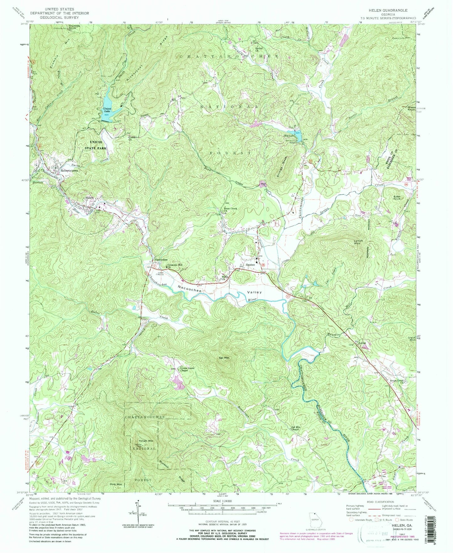
Classic USGS Helen Georgia 7.5'x7.5' Topo Map
Couldn't load pickup availability
Historical USGS topographic quad map of Helen in the state of Georgia. Typical map scale is 1:24,000, but may vary for certain years, if available. Print size: 24" x 27"
This quadrangle is in the following counties: Habersham, White.
The map contains contour lines, roads, rivers, towns, and lakes. Printed on high-quality waterproof paper with UV fade-resistant inks, and shipped rolled.
Contains the following named places: White County, Ben Creek, Car Creek, Chickamauga Branch, Chickamauga Creek, Church Branch, Craig Creek, Crumbly Knob, Grimes Nose, Horton Creek, Mauldin Mill Creek, McClure Creek, Murdock Ridge, Nacoochee Valley, Nester Branch, Pink Mountain, Rice Cabin Creek, Rogers Creek, Sal Mountain, Sal Mountain Chapel, Sautee Creek, Scorpion Hollow, Sky Lake, Smith Creek, Spoilcane Creek, Steep Creek, Unicoi State Park, Union Church, Union Grove Chapel, White Branch, White Church, Yonah Mountain, Bean Creek, Community Church, Aerial, Crumbly Mountain, Helen, Lynch Mountain, Nacoochee, Robertstown, Sautee, Sheep Knob, Sky Lake Dam, Unicoi State Park Lake Dam, Unicoi Lake, Mays Lake Dam, Mays Lake, Sautee Creek Watershed Number 13 Dam, Sautee Creek Watershed Number 13 Lake, Sautee Creek Watershed Number 12 Dam, Sautee Creek Watershed Number 12 Lake, Sautee Watershed Number 10 Dam, Sautee Watershed Number 10 Lake, Royal Lake Dam, Royal Lake, Chambers Lake Dam, Chambers Lake, Yonah Mountain Lookout Tower, Bean Creek Missionary Baptist Cemetery, Bethel Cemetery, Center Church, Chattahoochee Methodist Cemetery, Chattahoochee Methodist Church, Crescent Hill Cemetery, Helen Post Office, Helen School, Lynch (historical), Nacoochee Baptist Church, Nacoochee Methodist Cemetery, Nacoochee Baptist Cemetery, Nacoochee Church, Nacoochee Indian Mound, Robertstown School, Sautee Valley Historic District, Union Baptist Church Cemetery, Naguchee (historical), Aerial School (historical), Amys Creek Baptist Cemetery, Mauldins (historical), Childs Mine, Lot Ten Mine, White County Mine, Amys Creek Church, Bean Creek Church, Bethel Church, Cresecent Hill Church, Crumley Creek, Dukes Creek, Elder Knob, Sautee Nacoochee Post Office, Helen Division, City of Helen, Mount Yonah Elementary School, Resurrection Episcopal Church, Nacoochee Census Designated Place (historical), Sautee Census Designated Place (historical), Yonah Census Designated Place, Helen Fire Department, Habersham County Fire Department Station 16, White County Fire Department Station 3, White County Fire Department Station 7, White County Fire Department Station 8, Sautee-Nacoochee Census Designated Place, Helen Police Department