MyTopo
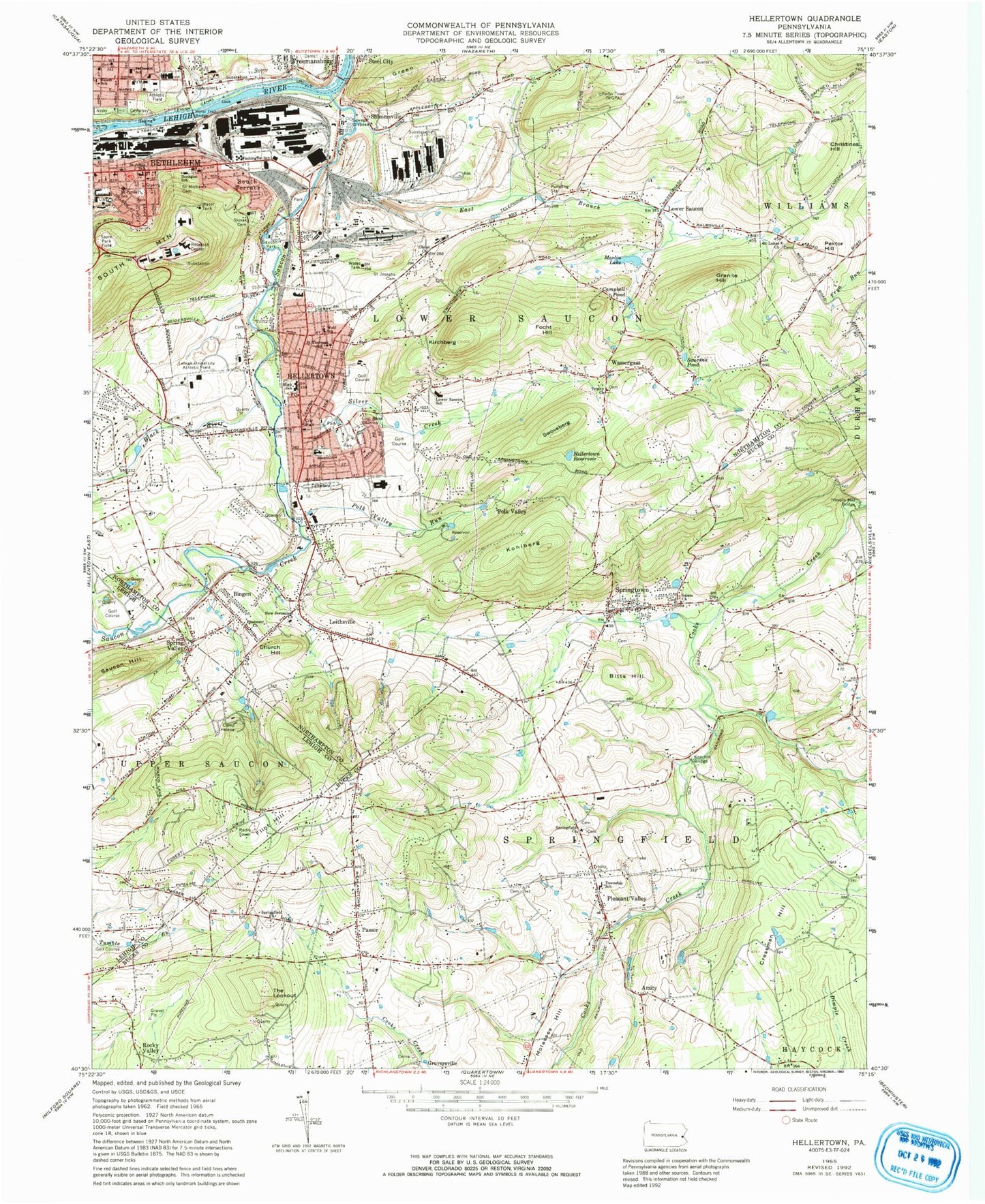
Classic USGS Hellertown Pennsylvania 7.5'x7.5' Topo Map
Couldn't load pickup availability
Historical USGS topographic quad map of Hellertown in the state of Pennsylvania. Map scale may vary for some years, but is generally around 1:24,000. Print size is approximately 24" x 27"
This quadrangle is in the following counties: Bucks, Lehigh, Northampton.
The map contains contour lines, roads, rivers, towns, and lakes. Printed on high-quality waterproof paper with UV fade-resistant inks, and shipped rolled.
Contains the following named places: Amity, Amity School, Bethlehem Fire Department Schweder Station, Bethlehem Landing Field, Bethlehem Police Department Center City Substation, Bethlehem Police Department Southeast Substation, Bethlehem Post Office, Bethlehem Steel Country Club, Bingen, Bitts Hill, Black River, Black River School, Borough of Hellertown, Camp Helena, Campbell Pond, Christ Church, Christines Hill, Church Hill, City of Bethlehem Emergency Medical Services, Cressman Hill, Dewey Fire Department and Emergency Medical Services Station 13, Didier, Donegan Elementary School, East Branch Saucon Creek, East Hills Middle School, Ebenezer Church, Eileen Run, Flint Hill, Focht Hill, Franklin School, Granite Hill, Green Hill, Gruversville, Gruversville Cemetery, Hellertown, Hellertown Borough Police Department, Hellertown Church, Hellertown High School, Hellertown Park, Hellertown Post Office, Hellertown Reservoir, Iron Hill, Jefferson School, Keystone School, Kirchberg, Klein School, Knechts Bridge, Kohlberg, Kulp Dam, Labuda Center for the Performing Arts, Lehigh University Athletic Field, Leithsville, Limekiln School, Lindbergh School, Locust Valley School, Lower Saucon, Lower Saucon Elementary School, Lower Saucon Fire Rescue Leithsville Station 16, Lower Saucon Fire Rescue Southeastern Station 16, Lower Saucon School, Marlin Hills, Marlin Lake, Minsi Trail Bridge, Molasses Hill, Monocacy Creek, New Jerusalem Church, Nisky Hill Cemetery, Northampton Heights, Number Two Dam, Passer, Pektor Hill, Penn School, Pleasant Hill Cemetery, Pleasant Valley, Pleasant Valley Evangelical Cemetery, Pleasent Valley Post Office, Polk Valley, Polk Valley Run, Polk Valley School, Putchat Dam, Reinhard Elementary School, Rocky Valley, Saint Cyrils School, Saint Johns School, Saint Josaphats Ukrainian Catholic Cemetery, Saint Lukes Church, Saint Michaels Cemetery, Saint Theresa School, Saints Cyril and Methodius Catholic Cemetery, Salem Church, Salem Evangelical Cemetery, Salem School, Saucon, Saucon Creek, Saucon Gap, Saucon Hill, Saucon Park, Saucon Valley Junior High School, Saucon Valley Senior High School, Saucon Valley Terrace, Saucona, Saucona Pond, Sayre Park Field, Shimersville, Silver Creek, South Bethlehem, South Terrace, Southeastern School, Specktown, Spring Hill Shopping Center, Spring Valley, Springfield, Springfield Church, Springfield Church of the Brethren Cemetery, Springfield Mennonite Meetinghouse and Cemetery, Springfield School, Springfield Township Elementary School, Springtown, Springtown Cemetery, Springtown Post Office, Springtown Volunteer Fire Company Station 40, Swoveberg, The Lookout, The Movies, Thomas Jefferson Elementary School, Township of Lower Saucon, Township of Springfield, Trinity Church, Trinity Evangelical Lutheran Church, Trinity Lutheran Cemetery, Union Cemetery, Upper Bucks Regional EMS Station 141, Washington School, Wassergass, Wassergass School, West Springtown School, WGPA-AM (Bethlehem), Wolf School, Woodland Hills Golf Course, WZZO-FM (Bethlehem), Yoder School, ZIP Codes: 18015, 18055, 18081