MyTopo
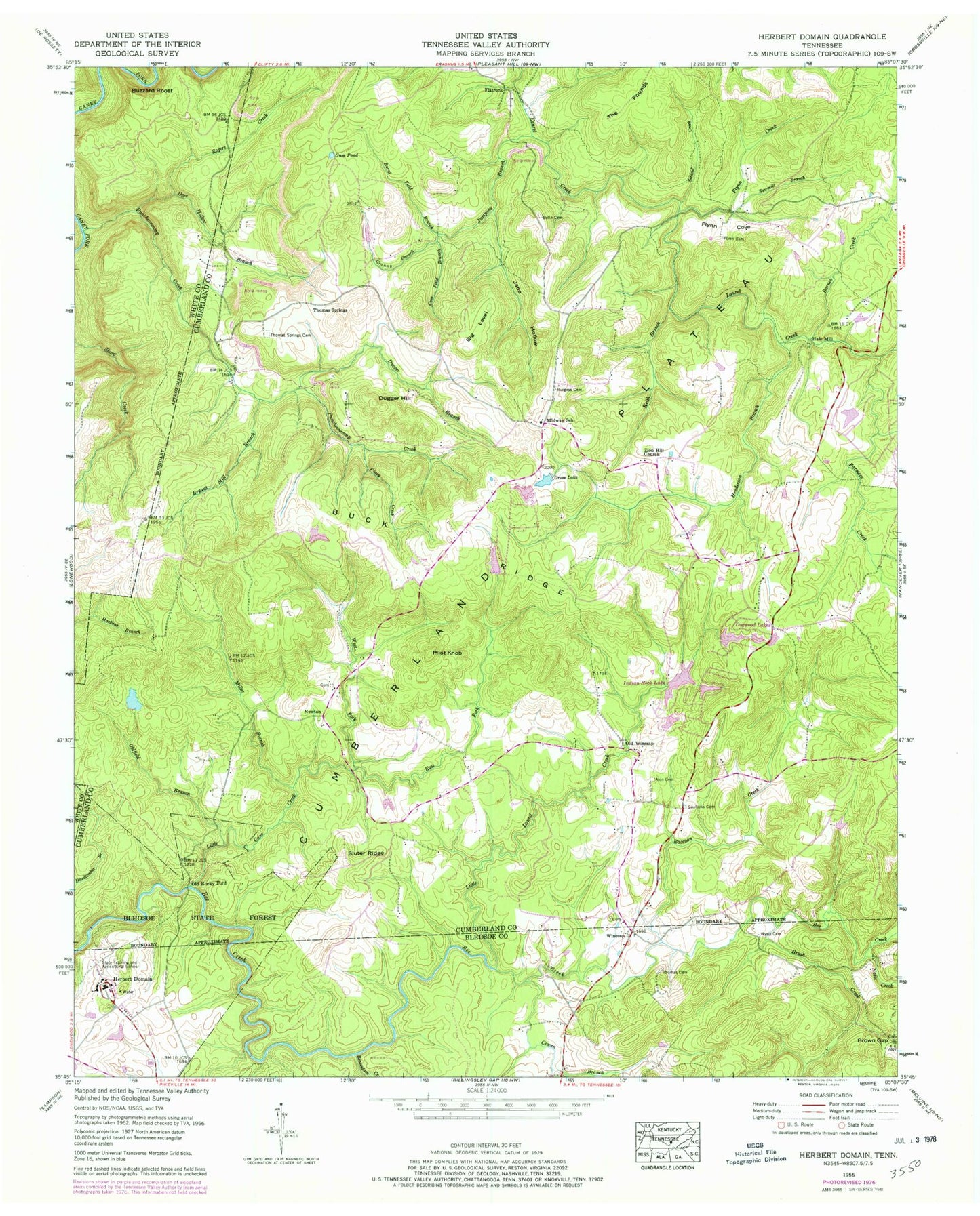
Classic USGS Herbert Domain Tennessee 7.5'x7.5' Topo Map
Couldn't load pickup availability
Historical USGS topographic quad map of Herbert Domain in the state of Tennessee. Typical map scale is 1:24,000, but may vary for certain years, if available. Print size: 24" x 27"
This quadrangle is in the following counties: Bledsoe, Cumberland, White.
The map contains contour lines, roads, rivers, towns, and lakes. Printed on high-quality waterproof paper with UV fade-resistant inks, and shipped rolled.
Contains the following named places: Short Creek, Sluter Ridge, Swallows Cemetery, Thomas Cemetery, Thomas Springs Cemetery, West Fork Little Cane Creek, Wyatt Cemetery, Zion Hill Church, Little Laurel Creek, Barnes Creek, Beaverdam Creek, Big Level, Bolin Cemetery, Brown Gap, Brush Creek, Bryant Mill Branch, Buck Ridge, Burgess Cemetery, Burnt Field Branch, Buzzard Roost, Cove Field Branch, Cowen Branch, Deadtimber Branch, Deer Hollow Branch, Dogwood Lakes, Dugger Branch, Dugger Hill, East Fork Little Cane Creek, Farmers Creek, Flatrock, Flynn Cemetery, Flynn Cove, Flynn Creek, Granny Branch, Gross Lake, Gum Pond, Henderson Branch, Herbert Domain, Jane Hollow, Jumping Branch, Keith Branch, Little Cane Creek, Little Laurel Creek, Midway School, Miller Branch, Nails Creek, Old Rocky Ford, Oldfield Branch, Pilot Knob, Piney Creek, Puncheoncamp Creek, Raccoon Creek, Rogers Creek, Sawmill Branch, Second Creek, State of Tennessee Reservoir, State of Tennessee Dam, Oldfield Branch Lake, Oldfield Branch Dam, Indian Rock Lake, Twin Lake, Twin Lake Dam, J P Wyatt Lake, J P Wyatt Dam, Spring Lake, Spring Lake Dam, Burgess School (historical), Cumberland Mountain Retreat, Flynn School (historical), Lake Park, Mount Gilead (historical), Mount Union School (historical), Zion Church (historical), Newton School (historical), Thomas Springs School (historical), Akin Cemetery, The Pounds, Grapevine (historical), Burgesstown (historical), Thomas Springs, Winesap, Hale Mill, Newton, Old Winesap, Grapevine School (historical), Winesap Freewill Baptist Church, Winesap Cemetery, Burgess Cemetery Number One, Burgess Cemetery Number Two, Newton Cemetery, Taft Youth Center, Flatrock School (historical), Midway, Perry Cemetery, Cumberland County Fire Department Station 5 - 1, Cumberland County Landfill