MyTopo
Classic USGS Hilton New York 7.5'x7.5' Topo Map
Couldn't load pickup availability
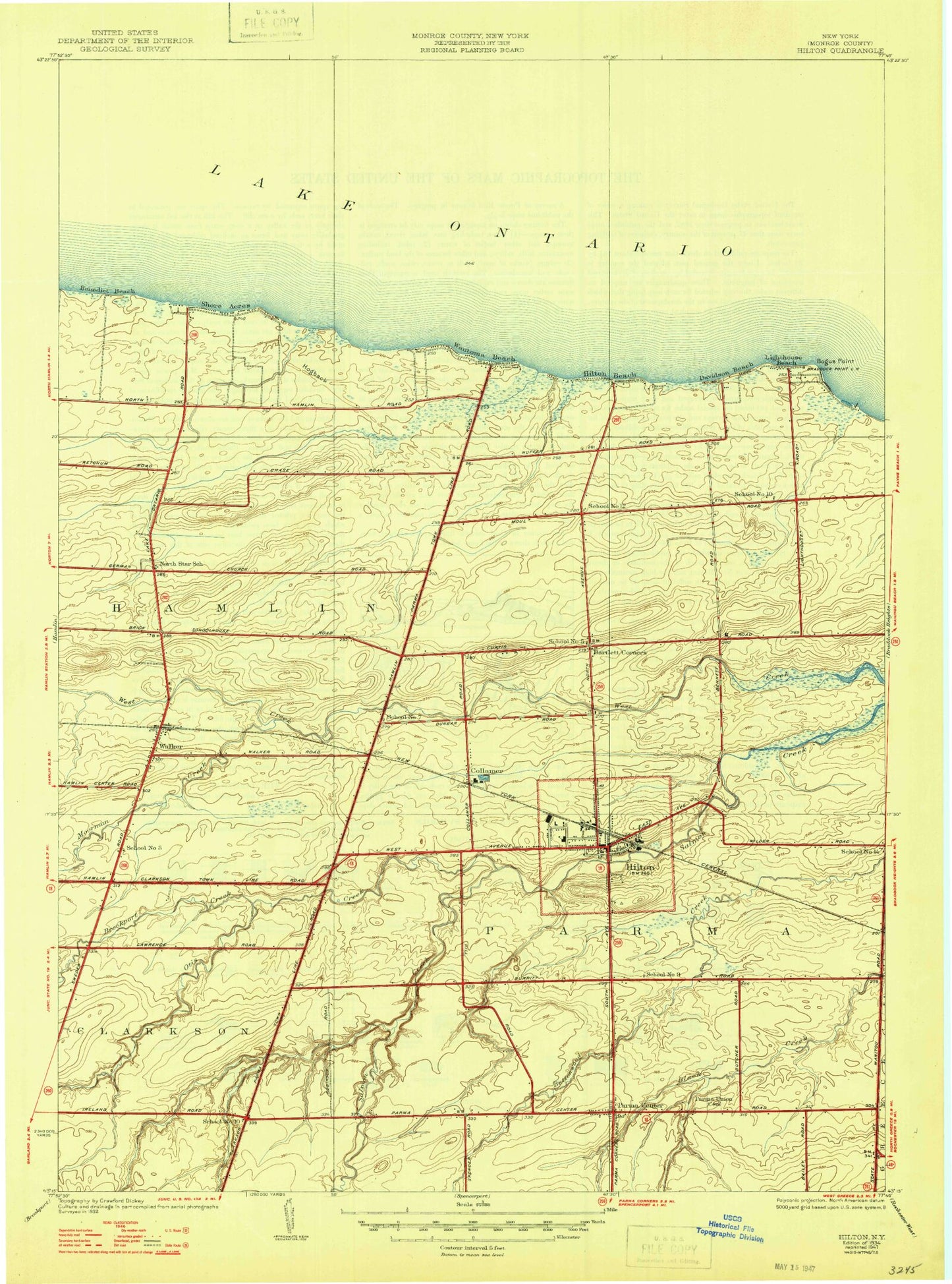
Historical USGS topographic quad map of Hilton in the state of New York. Typical map scale is 1:24,000, but may vary for certain years, if available. Print size: 24" x 27"
This quadrangle is in the following counties: Monroe.
The map contains contour lines, roads, rivers, towns, and lakes. Printed on high-quality waterproof paper with UV fade-resistant inks, and shipped rolled.
Contains the following named places: Bartlett Corners, Benedict Beach, Bogus Point, Brockport Creek, Brush Creek, Central Junior High School, Collamer, Cowsucker Creek, East Creek, Hilton, Jenkins School, Lighthouse Beach, Moorman Creek, Otis Creek, Parma Center, Parma Union Cemetery, Saint Paul Lutheran School, Shore Acres, Underwood School, Walker, Wautoma Beach, Merton Williams Middle School, Wautoma Shoals, Braddock Point Light, Hendershot Airport, Davison Beach, Town of Parma, Braddock Point Lighthouse (historical), North Star School (historical), School Number 5 (historical), School Number 5 (historical), School Number 7 (historical), School Number 9 (historical), School Number 10 (historical), School Number 10 (historical), School Number 12 (historical), School Number 14 (historical), Village of Hilton, Hilton Baptist Church, Hilton Village Hall, Saint Paul's Evangelical Lutheran Church, Saint Leo's Roman Catholic Church, Hilton Methodist Church, Zarpentine Farms, Hilton East Assisted Living Facility, Atchinson Family Pioneer Cemetery, Tyler Pioneer Cemetery, Smith Family Pioneer Cemetery, Wright Family Pioneer Cemetery, Hilton Community and Senior Center, Parma Public Library, Hilton Village Hall, Parma Town Hall, Hilton Post Office, Village Elementary School, Quest Elementary School, Hilton High School, Burch Farm, Kelly Farm, Gioia Farms, Greenwell Farms, North Ridge Farms, Kruger Farms, Buttonwood Farms, Bolton Farms, Walker Volunteer Fire Department, Hilton Fire Department, Bartlett Corners, Benedict Beach, Bogus Point, Brockport Creek, Brush Creek, Central Junior High School, Collamer, Cowsucker Creek, East Creek, Hilton, Jenkins School, Lighthouse Beach, Moorman Creek, Otis Creek, Parma Center, Parma Union Cemetery, Saint Paul Lutheran School, Shore Acres, Underwood School, Walker, Wautoma Beach, Merton Williams Middle School, Wautoma Shoals, Braddock Point Light, Hendershot Airport, Davison Beach, Town of Parma, Braddock Point Lighthouse (historical), North Star School (historical), School Number 5 (historical), School Number 5 (historical), School Number 7 (historical), School Number 9 (historical), School Number 10 (historical), School Number 10 (historical), School Number 12 (historical), School Number 14 (historical), Village of Hilton, Hilton Baptist Church, Hilton Village Hall, Saint Paul's Evangelical Lutheran Church, Saint Leo's Roman Catholic Church, Hilton Methodist Church, Zarpentine Farms, Hilton East Assisted Living Facility, Atchinson Family Pioneer Cemetery, Tyler Pioneer Cemetery, Smith Family Pioneer Cemetery, Wright Family Pioneer Cemetery, Hilton Community and Senior Center, Parma Public Library, Hilton Village Hall, Parma Town Hall, Hilton Post Office, Village Elementary School, Quest Elementary School, Hilton High School, Burch Farm, Kelly Farm, Gioia Farms, Greenwell Farms, North Ridge Farms, Kruger Farms, Buttonwood Farms, Bolton Farms, Walker Volunteer Fire Department, Hilton Fire Department