MyTopo
Classic USGS Honker Bay California 7.5'x7.5' Topo Map
Couldn't load pickup availability
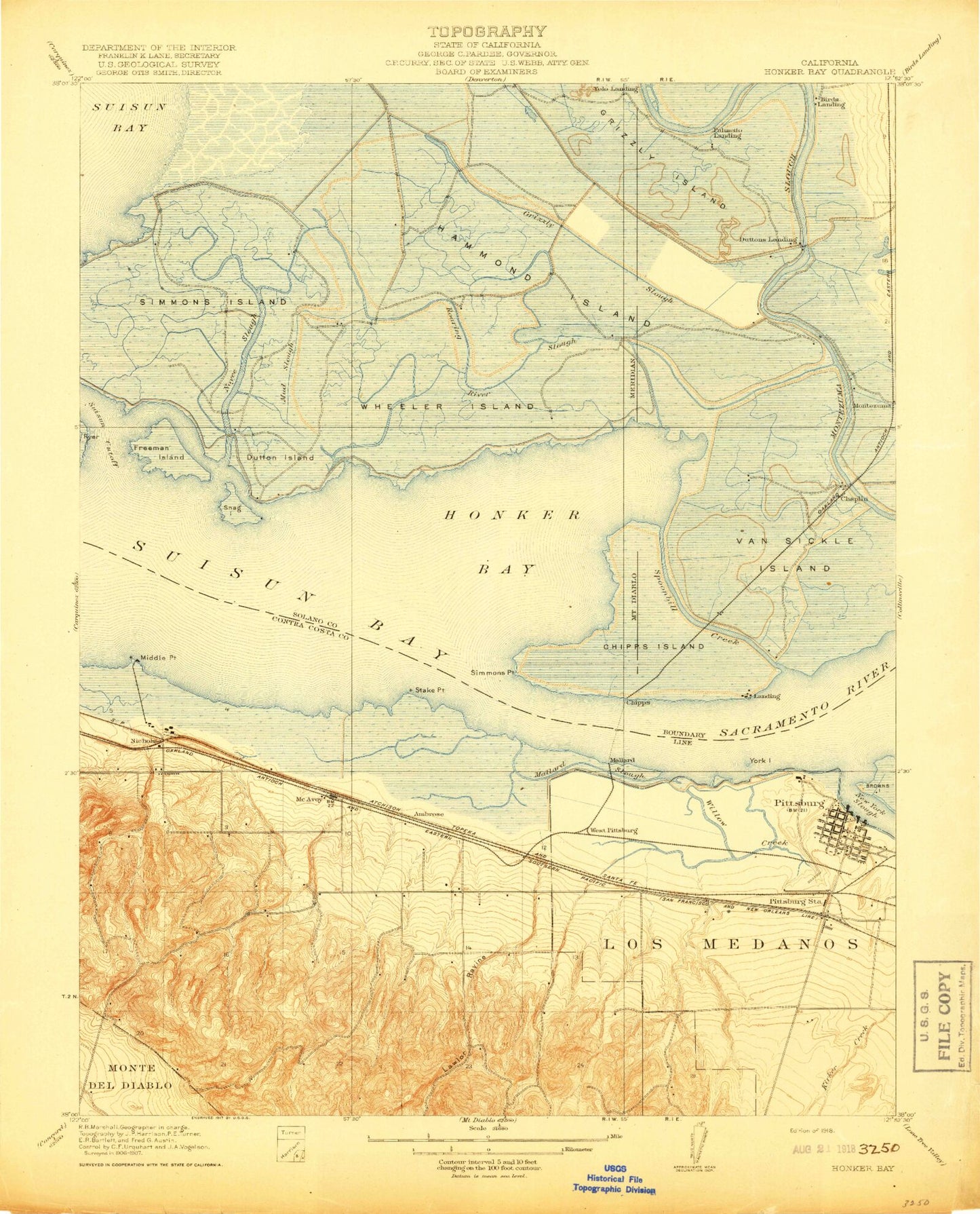
Historical USGS topographic quad map of Honker Bay in the state of California. Map scale may vary for some years, but is generally around 1:24,000. Print size is approximately 24" x 27"
This quadrangle is in the following counties: Contra Costa, Solano.
The map contains contour lines, roads, rivers, towns, and lakes. Printed on high-quality waterproof paper with UV fade-resistant inks, and shipped rolled.
Contains the following named places: Ambrose, Ambrose Park, Ambrose Recreation Center, Ambrose School, Atlantic Plaza Post Office, Atlantic Plaza Shopping Center, Bay Point, Bay Point Census Designated Place, Bay Point Post Office, Bel Air Elementary School, Bethel Baptist Bible Church, Birds Landing, Buchanan Park, Camp Stoneman, Champion Slough, Chipps, Chipps Island, Christian Center, Christian Renewal Ministries, Church of God in Christ, City of Pittsburg, Communidad Cristiana La Palabra De Dios, Community Baptist Church, Community Presbyterian Church, Contra Costa Canal, Contra Costa County Fire Protection District Station 84, Contra Costa County Fire Protection District Station 86, Contra Costa County Fire Protection District Station 87, Cornwall, DeAnza Park, Del Monte Recreation Center, Delta View Golf Course, Diamond, Duntton Landing, Dutton, Dutton Island, Duttons Landing, East Contra Costa Neighborhood Clinic, East Reach, First Methodist Church, Freeman Island, Gateway High School, Grace Bible Fellowship Church, Grace Lutheran Church, Grizzly Slough, Hammond Island, Heights Elementary School, Heritage Family Fellowship Church, Hillview Junior High School, Honker Bay, Howard Slough, Joy of Life Christian Center, Lawlor Ravine, Light the Bay Christian Academy, Los Medanos Elementary School, Mallard, Mallard Island, Mallard Slough, Marina High School, Marina Park, McAvoy, McAvoy Boat Harbor, McGlothen Church of God in Christ, Middle Ground Island, Middle Point, Mount Zion Baptist Church, Mud Slough, New York Landing, New York Point, Nichols, Norther Slough, Noyce Slough, Palmetto Landing, Parkside Elementary School, Pelican Point, Pittsburg, Pittsburg Adult Education Center, Pittsburg City Hall, Pittsburg Junior High School, Pittsburg Marina, Pittsburg Police Department, Pittsburg Post Office, Pittsburg Power Plant, Pittsburg Senior High School, Pittsburg Seventh Day Adventist Church, Pittsburg United Methodist Church, Pittsburg Yacht Club, Pittsburgh Station, Point Emmet, Point Palo Alto, Point Wall, Point Wise, Primera Iglesia Apostolica Pentecostal Church, Rack Creek, Radiant Life Ministries, Rio Vista Elementary School, Riverside High School, Riverview Middle School, Riverview Park, Roaring River Slough, Saint Dionysios Greek Orthodox Church, Saint Peter Martyr School, Saint Peter Martyrs Roman Catholic Church, Shiloh Christian Center, Shore Acres, Shore Acres Elementary School, Simmons Island, Simmons Point, Small World Park, Snag Island, Spoonbill, Spoonbill Creek, Sri Guru Ravidass Sabha, Stake Point, Stoneman Park, Suisun Bay, True Light Baptist Church, Van Sickle Island, Veterans Memorial Building, Village Elementary School, Vincent A Davi Library, West Reach, Wheeler Island, Yolo Landing, ZIP Code: 94565