MyTopo
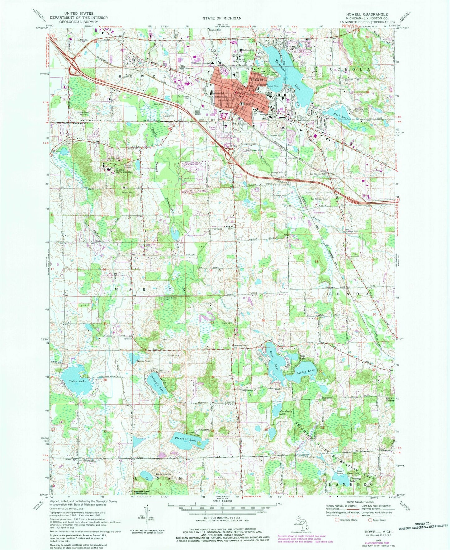
Classic USGS Howell Michigan 7.5'x7.5' Topo Map
Couldn't load pickup availability
Historical USGS topographic quad map of Howell in the state of Michigan. Typical map scale is 1:24,000, but may vary for certain years, if available. Print size: 24" x 27"
This quadrangle is in the following counties: Livingston.
The map contains contour lines, roads, rivers, towns, and lakes. Printed on high-quality waterproof paper with UV fade-resistant inks, and shipped rolled.
Contains the following named places: Chenango Lake, Camp Innistree, Cedar Lake, Coon Lake, Cranberry Lake, Earl Lake, Gale Lake, Gilkes Cemetery, Grass Lake, Harger Cemetery, Howell, Howell State Hospital, Lakeside Cemetery, Lakeview Cemetery, Marion and Genoa Drain, Saint Joseph Mercy Livingston Hospital, Mount Olivet Cemetery, Northeast School, Northwest School, Pardee Lake, Pleasant Lake, Saint Josephs School, Southeast School, Southwest School, Thompson Lake, Triangle Lake, Livingston County, Chemung Hills Country Club, WHMI-AM (Howell), City of Howell, Township of Marion, VG's Food Center Shopping Center, Grand River Plaza Shopping Center, Promenade Center Shopping Center, ReadyCare of Howell, Howell Internal Medicine Building, Howell Pediatrics, Kensington Valley Factory Shops Shopping Center, Livingston Commons Shopping Center, McPherson Community Hospital, Howell Area Fire Department Station 22, Howell Area Fire Department Station 21, Howell Area Fire Department Station 23, Bible Baptist Church, Prince of Peace Lutheran Church, New Vision Foursquare Church, Mount Hope Church, Howell Assembly of God Church, Liberty Baptist Church, Crossroads Apostolic Church, Heart of the Shepherd Lutheran Church, Church of the Nazarene, Arbour Meadows Community Church, South Side Baptist Church, First United Methodist Church, Church of Christ, Saint John's Episcopal Church, Grace Lutheran Church, Kingdom Hall of Jehovah's Witnesses, Saint Joseph Catholic Church, First Presbyterian Church, First Baptist Church, Kensington Woods High School, Howell Post Office, Howell High School, Howell High School Freshman Campus, Highlander Way Middle School, Howell Depot Museum, Fairlane Estates Mobile Home Park, Pathway School, Byron Road Medical Group, Howell Station, Baldwin Park, Paul Bennett Recreation Center, Howell Carnegie District Library, Howell Area Fire Department Station 20, Paul Bennett Field, Maple Street Park, Livingston County Sheriff's Office, Tanger Outlet Center, West Street Park, Challenger Elementary School, Voyager Elementary School, McPherson Park, Livingston County Courthouse, Howell City Hall, Howell Police Department, John S Page Athletic Field, Lakeside Park, Howell City Park, Fairlawn Estates Mobile Home Park, Elizabeth Park, Oak Crest Trailer Park, Promenade Shopping Center, Park Street Park, Argyle Street Park, Chateau Estates Mobile Home Park, Lansing Community College-Livingston County Center, New Towne Shopping Center, Lucy Road Park, Cleary University, Marion Oaks Golf Course, Howell Rest Area, Ann Arbor Railroad Historical Marker, County Courthouse Historical Marker, Howell Carnegie Library Historical Marker, Livingston County Press Historical Marker, Opera House Historical Marker, Livingston County Poor Farm Cemetery, Drew Cemetery, Livingston County Genoa Emergency Medical Services Station