MyTopo
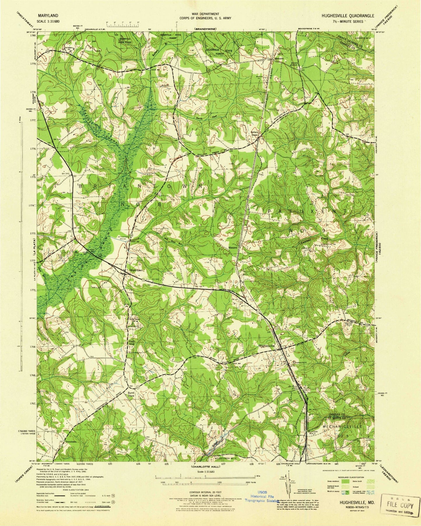
Classic USGS Hughesville Maryland 7.5'x7.5' Topo Map
Couldn't load pickup availability
Historical USGS topographic quad map of Hughesville in the state of Maryland. Typical map scale is 1:24,000, but may vary for certain years, if available. Print size: 24" x 27"
This quadrangle is in the following counties: Charles, Prince George's, St. Mary's.
The map contains contour lines, roads, rivers, towns, and lakes. Printed on high-quality waterproof paper with UV fade-resistant inks, and shipped rolled.
Contains the following named places: Bryantown Bridge, Burnt Store, Devils Nest, Gallant Green, Malcolm Elementary School, Mill Dam Run, Notre Dame High School, Old Field Church, Piney Branch, Saint Mary's School, Saint Peters School, Smoots Pond Run, Southern Maryland Public Works Camp, Bryantown, Grosstown, Hughesville, Malcolm, Masons, Jameson Dam, Gilbert Pond, Wolf Den Branch, WNTL-AM (Indian Head), WXTR-FM (Waldorf), Belle Ridge Farms, Bellewood, Bowen Estates, Briar Ridge, Bryantown Estates, Bryantown Hills, Bryantown Historic District, Bryantown Post Office, Cameron Ridge, Carrico Mill Estates, Charles County Gardens, Clayton Run Estates, Edelen Estates, Forest Estates, Forest Glen Estates, Forest Park, Forest Park Baptist Church, Gallant Acres, Gallant Green Woods, Grace Brethren Church, Green Spring, Hickory Thicket, Hidden Valley, Hughesville Company 2 Fire Station, Hughesville High School, Hughesville Industrial Park, Hughesville Pond, Hughesville Pond Recreation Area, Hughesville Post Office, Hughesville Manor, Hunters Farms, Karen Knolls, Kindy Hook, Mandleys, Meadow Creek Manor, Meadowbrook, Metro Gun Club, New Covenant Church, Oak Estates, Oakland Acres, Old Fields Episcopal Church Cemetery, Independence Village, Park Estates, Pine Grove Estates, Plainview Gardens, Ridgeview, Saint Charles Church of the Nazarene, Saint Mary Catholic Church, Saint Mary's Catholic Church Cemetery, Saint Peters Catholic Church, Saint Peter's Catholic Church Cemetery, Sandy Level Estates, Serenity Woods, Sunnyside, Sylvanhurst, T C Martin Elementary School, Three Brothers, Walnut Hills, Woodridge Acres, Zekiah Valley, Breezy Knolls, Knolland, McKays Plaza Shopping Center, North Indian Creek Estates, Sothorons Desire (historical), Underwood (historical), District 8 Bryantown, Hughesville Volunteer Fire Department and Emergency Medical Services, Grace Christian Academy of Maryland, Hughesville Census Designated Place, Bryantown Census Designated Place, Timbuktu Arabian Horse Farm, Timbuktu Arabian Horse Farm, Middleton's Cedar Hill Farm, AAA Transport, Society of Friends Cemetery