MyTopo
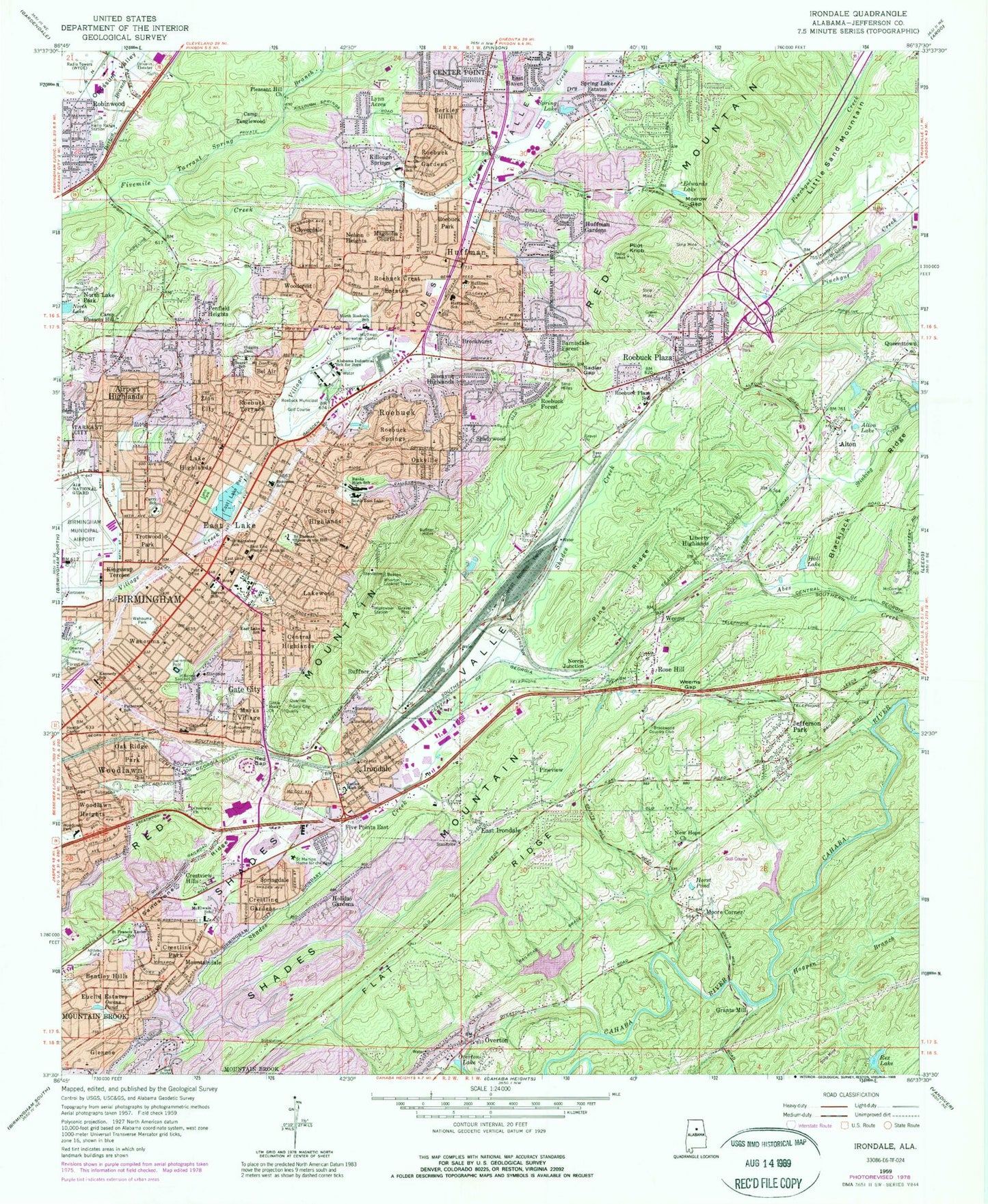
Classic USGS Irondale Alabama 7.5'x7.5' Topo Map
Couldn't load pickup availability
Historical USGS topographic quad map of Irondale in the state of Alabama. Map scale may vary for some years, but is generally around 1:24,000. Print size is approximately 24" x 27"
This quadrangle is in the following counties: Jefferson.
The map contains contour lines, roads, rivers, towns, and lakes. Printed on high-quality waterproof paper with UV fade-resistant inks, and shipped rolled.
Contains the following named places: Abes Creek, Airport Highlands, Alabama Industrial School for Boys, Alfretta Mines, Alfretta Number 1 Mine, Alfretta Number 2 Mine, Alton, Alton Elementary School, Alton Lake, Arthur School, Autumn Chase, Banks High School, Barnisdale Forest, Barrett Elementary School, Barton Branch, Bass Cemetery, Battleground, Bel Air, Bentley Hills, Berkley Hills, Birmingham Municipal Airport-North, Birmingham Municipal City Police Airport, Biscayne Highlands, Bradford Clinic, Brentwood Hills, Brookhurst, Brookmont, Brookwood Country Club, Bryan Estates, Burton D Olshan Airport, Bush Cemetery, Cahaba Landing, Camp Blossom Hill, Camp Tanglewood, Central Highlands, Century Plaza Shopping Center, Cherokee Bend, Cherokee Bend Elementary School, Cherokee Brook Estates, Cherry Brook Estates, Christian Elementary School, City of Birmingham - Roebuck Plaza Lake, City of Irondale, Cloverdale, Crestline Gardens, Crestline Park, Crestview Hills, Curry Elementary School, Dale, Downey Park, Drummond Lake, Drummond Lake Dam, Dry Creek, Earltown Cemetery, East End Meml Hospital Airport, East End Memorial Hospital, East Haven, East Irondale, East Lake, East Lake Cemetery, East Lake Elementary School, East Lake Park, East Lake Park Dam, East Town Plaza Shopping Center, Eastbrook Manor, Eastpointe, Eastwood Mall Shopping Center, Eastwood Mobile Home Plaza, Eastwood Shopping Plaza, Edwards Lake, Edwards Lake Spring, Eldorado Park, Ellard Park, Ernest Norris Yards, Euclid Estates, Festival Shopping Center, Five Points East, Flat Ridge, Forest Crest Cemetery, Gate City, Gate City Elementary School, Glencoe, Going School, Grants Mill, Grants Mill Station Shopping Center, Grantswood Community School, Hall Lake, Hampton Place, Higgins Cemetery, Hill Crest Behavioral Health Services, Hogpen Branch, Holiday Gardens, Horst Pond, Huffman, Huffman Gardens, Huffman High School, Huffman Middle School, Hunters Hill, Irondale, Irondale Elementary School, Irondale Junior High School, Irondale Municipal Park, Irondale Plaza Shopping Center, Jack M Dabbs Area Vocational Center, Jefferson Memorial Gardens, Jefferson Memorial Gardens Dam, Jefferson Park, Jones Valley, Kennedy Middle School, Killough Springs, Kingsway Terrace, Lake Highlands, Lakeside Airport, Lakewood, Lawson Stadium, Liberty Highlands, Little Sand Mountain, Lynn Acres, Lynn Park, Magnolia Courts, Marks Village, McCombs Cemetery, McElwain Baptist Cemetery, McElwain Magnet Elementary School, Montrose, Moore Corner, Morrow Gap, Mountain Brook Swim and Tennis Club, Mountain Forest, Mountaindale, Nelson Heights, Noland Long Term Hospital of Birmingham, Norris Junction, North Lake, North Lake Park, North Roebuck Elementary School, Nottingham, Oak Ridge Park, Oakville, Old Irondale Furnace, Old Leeds Forest, Oliver Elementary School, Osborne Lake, Osborne Lake Dam, Overton, Overton Elementary School, Overton Lake, Owens Pond, Paragon Estates, Parkway East Huffman Shopping Center, Penfield Heights, Pilot Knob, Pine Knoll Vista, Pine Ridge, Pine Tree Country Club, Pine Tree Country Club Dam, Pine Tree Country Club Lake, Pineview, Plaza Mobile Home Park, Poplar Spring Hollow, Putnam Elementary School, Queenstown Industrial Park, Ratliffe Mine, Red Gap, Reed Cemetery, Rex Lake, Rex Lake Dam, Robinwood, Rock Ridge, Roebuck, Roebuck Crest Estates, Roebuck Forest, Roebuck Gardens, Roebuck Municipal Golf Course, Roebuck Park, Roebuck Plaza, Roebuck Plaza Elementary School, Roebuck Plaza Shopping Center, Roebuck Recreation Center, Roebuck Shopping City Shopping Center, Roebuck Springs, Roebuck Terrace, Rose Hill, Ruffner, Ruffner Mines, Ruffner Mountain Nature Center, Saddlebrook, Sadler Gap, Saint Barnabas School, Saint Francis Xavier School, Saint Thomas Home on the Hill School, Saint Vincent's Hospital East, Sandstone Ridge, Sears Elementary School, Select Specialty Hospital Birmingham, Shady Acres Trailer Park, Shadywood, Silky Woods, Sloss Mine, Sloss Quarry, South Highlands, Spring Lake, Spring Lake Estates, Springdale, Stinking Creek, Stonehedge, Stoneridge, Sunrise East, Tarrant Spring Branch, Tom Bradford Park, Trinity Medical Center, Trotwood Park, Tutwiler Farm, Valley Crest Estates, Village East Shopping Center, Von Dale, W253-FM (Birmingham), W276-FM (Center Point), Wahouma, Wahouma Park, Weems, Weems Gap, Wharton Lookout Tower, WLPH-AM (Irondale), Woodcrest, Woodlawn Heights, Wrenn Gap, Wright School, WYDE-AM (Birmingham), Zion City, Zion Memorial Gardens, ZIP Codes: 35206, 35210, 35213, 35235