MyTopo
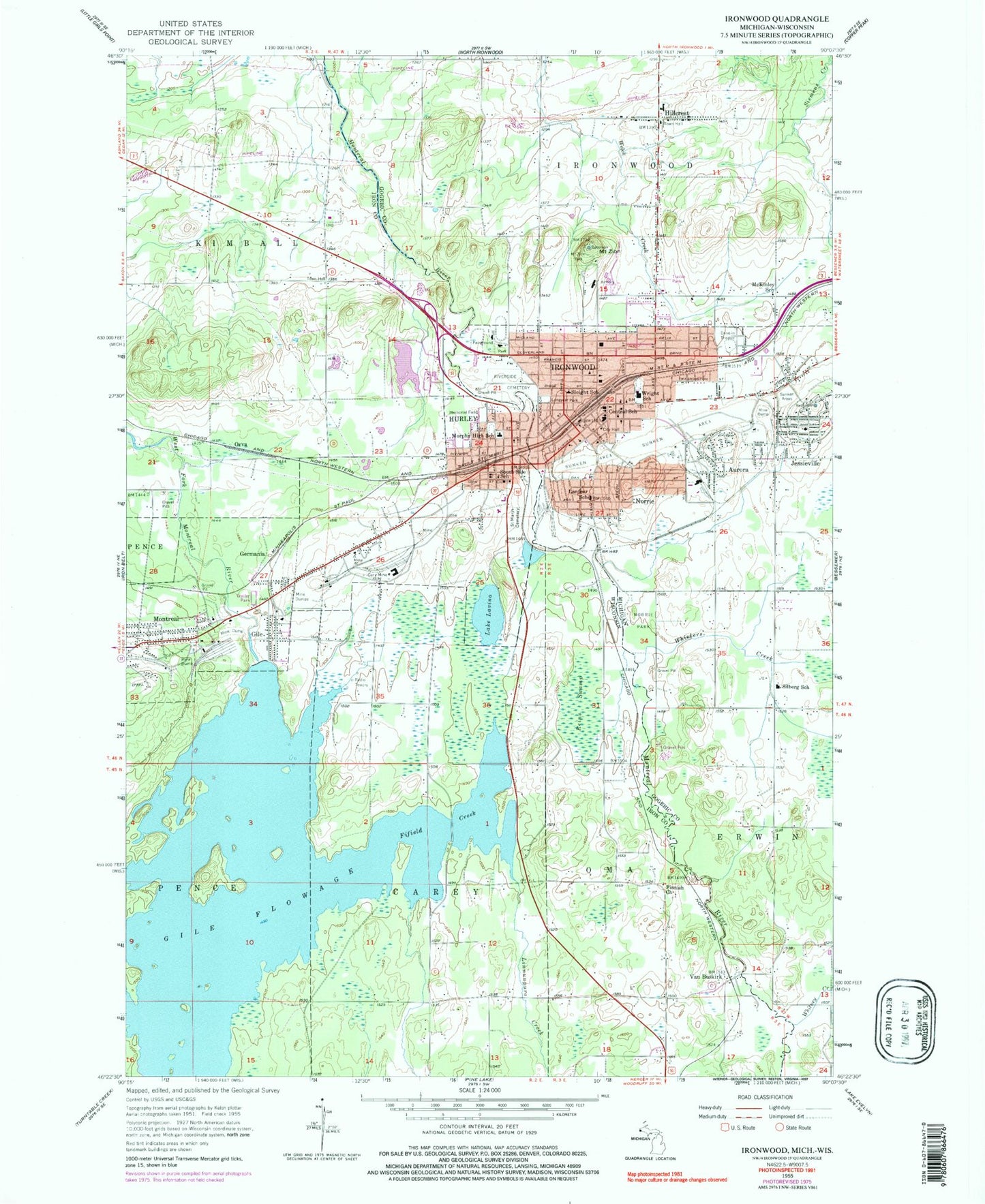
Classic USGS Ironwood Michigan 7.5'x7.5' Topo Map
Couldn't load pickup availability
Historical USGS topographic quad map of Ironwood in the states of Michigan, Wisconsin. Map scale may vary for some years, but is generally around 1:24,000. Print size is approximately 24" x 27"
This quadrangle is in the following counties: Gogebic, Iron.
The map contains contour lines, roads, rivers, towns, and lakes. Printed on high-quality waterproof paper with UV fade-resistant inks, and shipped rolled.
Contains the following named places: All Saints Catholic Academy, Apostolic Lutheran Church, Assembly of God Church, Aurora, Beacon Ambulance Service, Campus Suites Residence Hall, Carl Kleimola Applied Technology Center, Carnegie Library, Cary Mine, Cary Public School, Central Buskirk School, Central School, City of Hurley, City of Ironwood, City of Montreal, Cominski Creek, Construction Technology Annex, Curry House Historical Marker, Curry Park, David G Lindquist Student Center, Downtown Ironwood Pocket Park, Dr Joseph Lalich Charter School, Fifield Creek, Finnish Church, First Presbyterian Church, Germania, Gile, Gile Flowage, Gile Flowage 70, Gile Reservoir 2WP271 Dam, Gogebic Community College, Gogebic County Fairgrounds, Gogebic Range, Grace Community Fellowship, Hiawatha Park, Hillcrest, Hillcrest Post Office, Hurley, Hurley City Hall, Hurley Elementary School, Hurley Fire Department, Hurley Middle / High School, Hurley Police Department, Hurley Post Office, Hurley Presbyterian Church, Hurley Public Library, Interstate Falls, Iron County Courthouse, Iron County Jail, Iron County Memorial Building, Iron County Sheriff's Office, Ironwood, Ironwood City Hall Historical Marker, Ironwood Department of Public Safety, Ironwood Fire Department, Ironwood Police Department, Ironwood Post Office, Ironwood Station, Ironwood Township Volunteer Fire Department, Jacob Solin Center for Business Education, Jehovahs Witness Kingdom Hall, Jessieville, Jessieville Post Office, Jessieville Station, Josephsons Nursing Home, Kimball Fire Department, Kimball Town Hall, Kuitunen Park, La Blonde G1679 Dam, Lake Lavina, Lake Michelle, Lighthouse Faith Center, Linnunpuro Creek, Living Water Missionary Church, Longyear Park, McKinley School, Meadville School, Memorial Field, Montreal, Montreal Fire Department, Montreal Wastewater Treatment Plant, Mount Zion, Mount Zion Park, Mount Zion Ski Chalet, Mount Zion Ski Hill, Murphy High School, Newport Hill Historical Marker, Norrie, Norrie Elementary School, Norrie Park, Norrie Park Historical Marker, Northwoods Christian Academy, Orva, Our Lady of Peace Church, Pat O'Donnell Civic Center, Peterson Falls, Reins Swamp, Riverside Cemetery, Rutger Erickson Academic Center, Saint Marys Cemetery, Saint Marys Roman Catholic Church, Saint Marys School, Saint Paul Lutheran Church, Saint Pauls Evangelical Lutheran Church, Salem Lutheran Church, Silberg School, Sleight Elementary School, South Carey School, South Side School, Transfiguration Episcopal Church, Trinity Lutheran Church, Van Buskirk, Wesley United Methodist Church, Whiskers Creek, Whitney Creek, WIMI-FM (Ironwood), WJMS-AM (Ironwood), Woodland Church, Wright School, Zion Evangelical Lutheran Church, ZIP Code: 54525