MyTopo
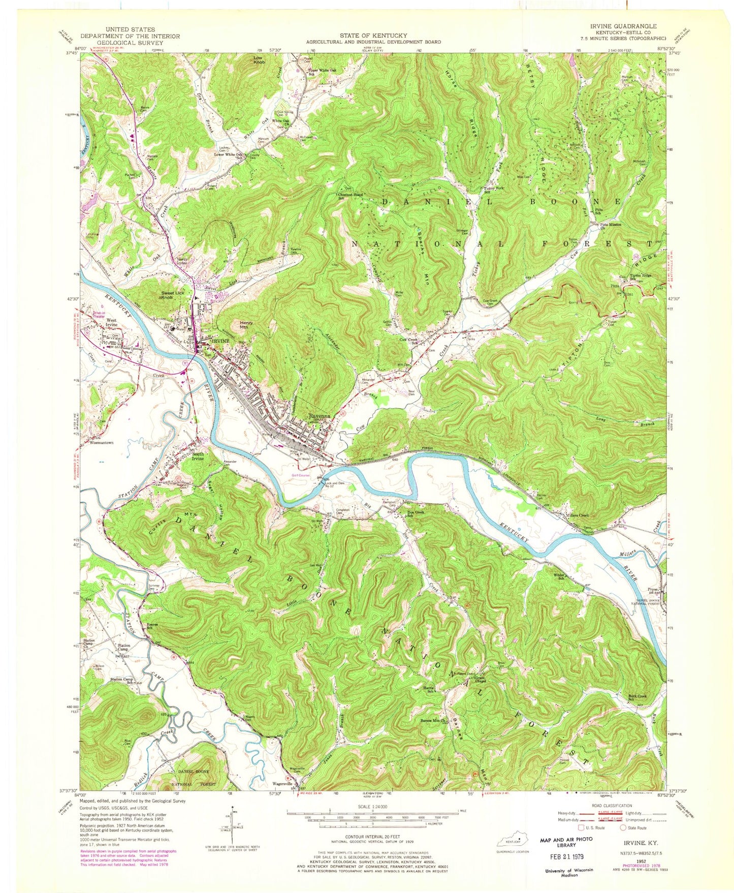
Classic USGS Irvine Kentucky 7.5'x7.5' Topo Map
Couldn't load pickup availability
Historical USGS topographic quad map of Irvine in the state of Kentucky. Map scale may vary for some years, but is generally around 1:24,000. Print size is approximately 24" x 27"
This quadrangle is in the following counties: Estill.
The map contains contour lines, roads, rivers, towns, and lakes. Printed on high-quality waterproof paper with UV fade-resistant inks, and shipped rolled.
Contains the following named places: Alexander Branch, Alexander Cemetery, Antioch Cemetery, Arvin Cemetery, Barnes Cemetery, Barnes Mountain, Barnes Mountain Church, Battle of Irvine Historical Marker, Betsy Ridge, Big Doe Creek, Brinegar Cemetery, Buck Creek, Buck Creek School, Campbell Cemetery, Campbell Creek, Captain John C Wilson Historical Marker, Chamberlain Branch, Chestnut Stand School, City of Irvine, City of Irvine Fire Department Station 1, City of Ravenna, Clear Creek, Congleton Cemetery, Cool Spring Cemetery, Cow Creek, Cow Creek Baptist Church, Cow Creek Cemetery, Cow Creek School, Crooked Creek, Curtis Mountain, Dam Number 12, Doe Creek School, Dry Branch, Durbins Store, Easter Valley Church, Estill Collegiate Institute Historical Marker, Estill County, Estill County Cemetery, Estill County Emergency Medical Services, Estill County High School, Estill County Historical Marker, Estill County Middle School, Estill County Sheriff's Department, Estill Springs Historical Marker, Estill Steam Furnace Historical Marker, Furnace Post Office, Grace Chapel, Gray Cemetery, Griffin Cemetery, Harris School, Henry Mountain, Hoover Cemetery, Horse Ridge, Irvine, Irvine Historical Marker, Irvine Police Depaartment, Irvine Post Office, K. N. Junction, Lackey Cemetery, Little Doe Creek, Low Knob, Lower White Oak, Lower White Oak School, MacIntosh Cemetery, Marcum and Wallace Memorial Hospital, Marcum Cemetery, Masters Cemetery, Masters Creek, McDowell Cemetery, Miller Cemetery, Millers Creek, Moore Cemetery, Mount Tabor Cemetery, Mount Tabor Christian Church, Mouth of Millers Creek Post Office, Neal Cemetery, Noland Cemetery, North Irvine, Old Witt School Neighborhood, Peters Cemetery, Pitts, Pitts Mission Church, Pitts Post Office, Pitts School, Powell Cemetery, Pryse Post Office, Puckett Cemetery, Ravenna, Ravenna Fire Department, Ravenna Police Department, Ravenna Post Office, Rawlins Cemetery, Red Lick Creek, Reeves, Reeves School, Rice Cemetery, Rogers Fork, Scotts Landing, Scrivener Branch, Scrivner Cemetery, South Irvine, Sparks Cemetery, Sparks Mountain, Star Mountain, Station Camp, Station Camp Church, Station Camp Creek, Station Camp School, Station Camp Trading Post Historical Marker, Stump, Stump School, Sugar Hollow, Sweet Lick, Sweet Lick Branch, Sweet Lick Knob, Texola Railroad Station, Tickey Fork, Tickey Fork School, Tipton Cemetery, Tipton Ridge, Tipton Ridge School, Tuggle Branch, Upper White Oak School, Wagers Cemetery, Wagersville, Wagersville Cemetery, Wagersville Post Office, West Irvine, White Oak Church, White Oak Church Cemetery, White Oak Creek, Wilder, Wilder School, Wilson Cemetery, WIRV-AM (Irvine), Wise Cemetery, Witt Cemetery, ZIP Code: 40336