MyTopo
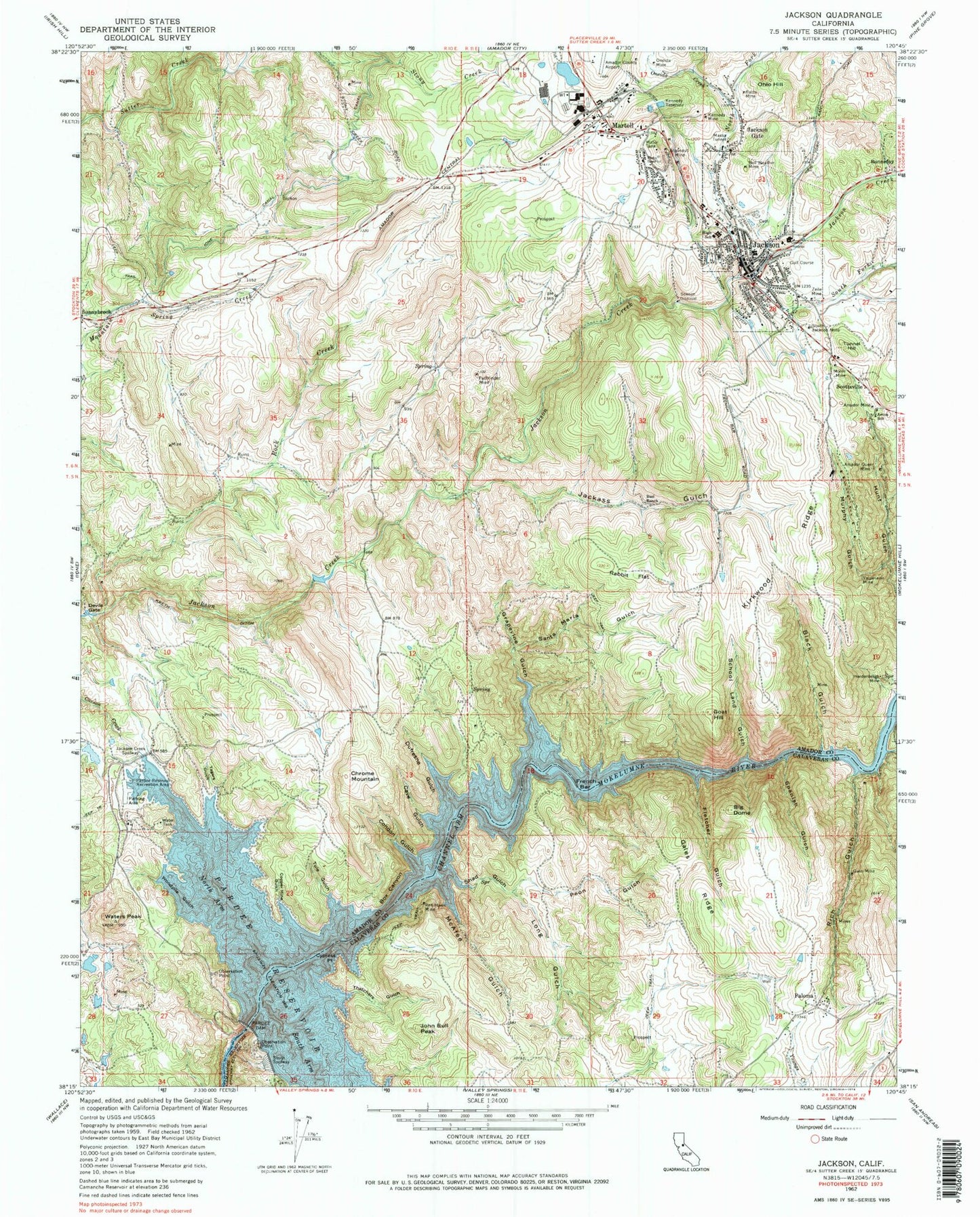
Classic USGS Jackson California 7.5'x7.5' Topo Map
Couldn't load pickup availability
Historical USGS topographic quad map of Jackson in the state of California. Typical map scale is 1:24,000, but may vary for certain years, if available. Print size: 24" x 27"
This quadrangle is in the following counties: Amador, Calaveras.
The map contains contour lines, roads, rivers, towns, and lakes. Printed on high-quality waterproof paper with UV fade-resistant inks, and shipped rolled.
Contains the following named places: Aetna School, Amador Mine, Amador Queen Mine, Argonaut Mine, Bell Weather Mine, Big Dome, Black Gulch, Box Canyon, Cave Gulch, Channel Arm, Chrome Mountain, Copper Mine Gulch, Cypress Point, Devils Gate, Dufresne Gulch, Fletcher Gulch, Gales Ridge, Goat Hill, Grapevine Gulch, Gwin Mine, Hardenbergh Mine, Ione Canal, Jackass Gulch, Jackson City Cemetery, Jackson Creek Spillway, Jackson Gate, John Bull Peak, Kennedy Mine, Kennedy Reservoir, Kirkwood Ridge, Kreth Ditch, Long Gulch, Martell, Massa Tunnel, McAfee Gulch, Minister Gulch, Moore Ditch, Moore Mine, Murphy Gulch, North Arm, North Fork Jackson Creek, Oneida Creek, Oneida Mine, Pardee Dam, Pardee Reservoir, Pardee Reservoir Recreation Area, Pathfinder Mine, Peon Gulch, Poorman Gulch, Rabbit Flat, Red Hawk Mine, Rich Gulch, Santa Maria Gulch, School Land Gulch, Shad Spring Gulch, Rock Creek, South Arm, South Fork Jackson Creek, South Jackson Mine, South Spillway, Spanish Gulch, Thatchers Gulch, Tule Gulch, Tunnel Hill, Valparaiso Mine, Waters Peak, Woodpile Gulch, Yagers Gulch, French Bar, Westover Field Amador County Airport, Bonnefoy, Jackson, Ohio Hill, Paloma, Scottsville, Amador County Courthouse, Sutter Amador Hospital, Amador County Jail, Amador County Library, Amador County Museum, Amador Plaza Shopping Center, Argonaut High School, Bethel Assembly of God Church, Congregation B'nai Israel (historical), Detert Park, First Baptist Church, Jackson Elementary School, Jackson Junior High School, Jackson Post Office, Jackson United Methodist Church, Kennedy Tailing Wheels Park, Louisiana House (historical), Plaza Park, Saint Patricks Catholic Church, Saint Sava Serbian Orthodox Church, Paloma Community Open Bible Church, Jackson Division, City of Jackson, City of Sutter Creek, Martell Census Designated Place, Jackson City Fire Department Station 131, Jackson City Fire Department Station 132, American Legion Ambulance, Jackson Police Department, Amador County Sheriff's Office, California Highway Patrol Valley Division - Amador, Pioneer Jewish Cemetery, Sunset View Cemetery, Saint Sava Serbian Orthodox Cemetery, Saint Patrick Catholic Cemetery