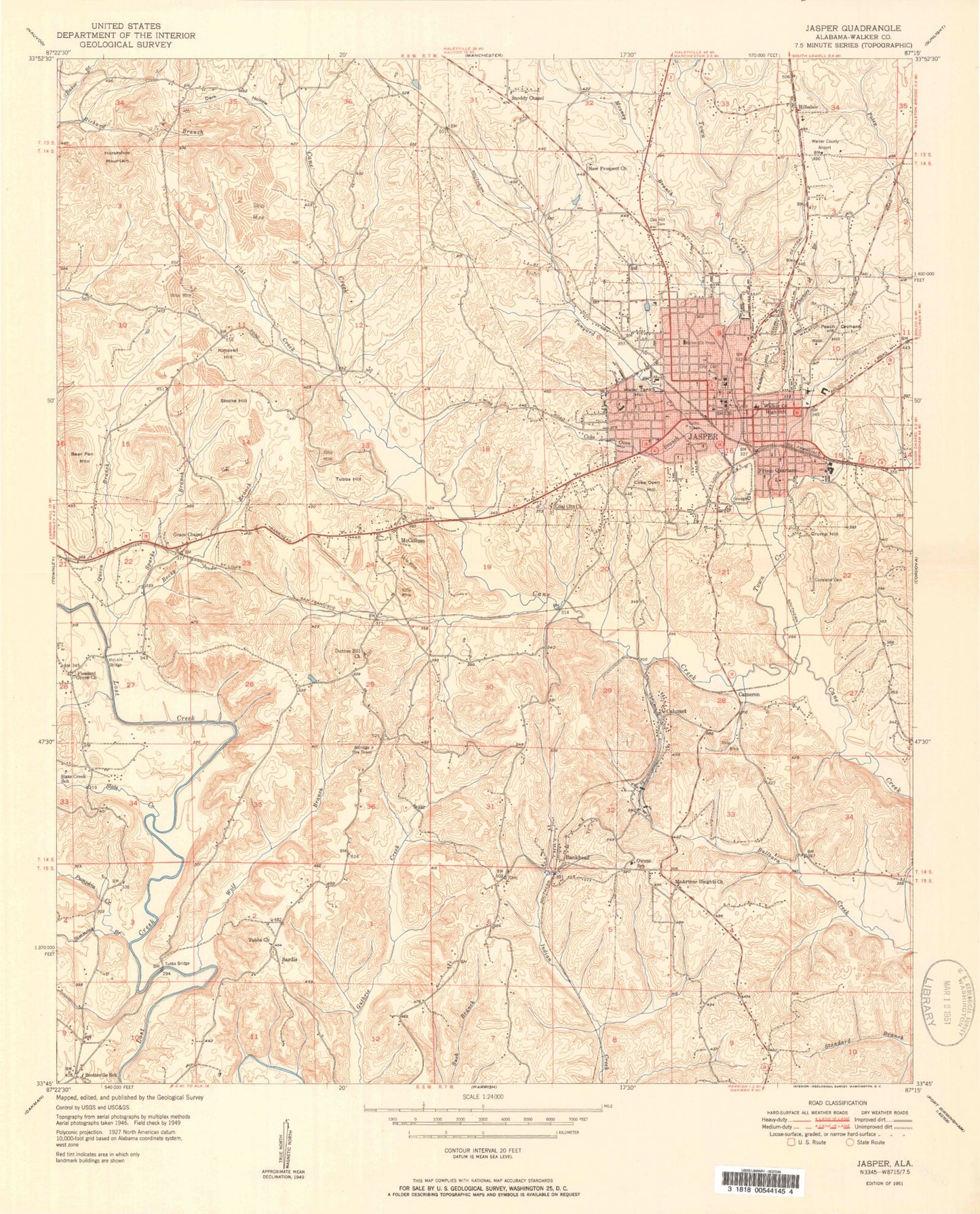
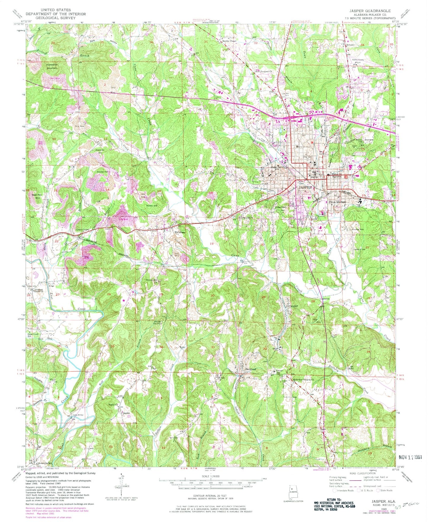
MyTopo
Classic USGS Jasper Alabama 7.5'x7.5' Topo Map
Couldn't load pickup availability
Historical USGS topographic quad map of Jasper in the state of Alabama. Map scale may vary for some years, but is generally around 1:24,000. Print size is approximately 24" x 27"
This quadrangle is in the following counties: Walker.
The map contains contour lines, roads, rivers, towns, and lakes. Printed on high-quality waterproof paper with UV fade-resistant inks, and shipped rolled.
Contains the following named places: Academy Hill, Agape Christian Center, Aldridge Fire Tower, Arrow Head Golf Course, Bankhead, Bankhead Shaft Mine, Bear Pen Mountain, Bible Methodist Campground, Birmingham Avenue Church of God, Calumet, Calumet Number 2 Slope Mine, Cameron, Carter Temple African Methodist Episcopal Church, Carver Park, Cedar Hill Church, Central Baptist Church, Childress Mine, Church of the Holy Bible, City of Jasper, Coal City Baptist Church, Coke Oven Branch, Coke Oven Hill, Copeland Cemetery, Crump Hill, Cunningham Mine, Dark Hollow, Dark Hollow Drift Mine, Davis Mine, Doctors Branch, Dutton Hill Missionary Baptist Church, Dutton Valley Church, Eastside Baptist Church, English Village Shopping Center, First Assembly of God Church, First Baptist Church, First Baptist Corona Avenue Church, First Christian Church, First Church of the Nazarene, First Free Will Baptist Church, First Methodist Church, First Pentecostal Church, First Presbyterian Church, Flat Creek, Frisco Quarters, Gamble Mines, Gambrell Mines, Grace Chapel Church of the Nazarene, Hawes Drift Mine, Hillard Drift Mine, Hillard Mine, Hillsdale, Horseshoe Mountain, Hudson Mobile Home Park, James Fowler Park, Jasper, Jasper Division, Jasper Fire Department Station 1, Jasper Fire Department Station 2, Jasper Mall Shopping Center, Jasper Memorial Cemetery, Jasper Methodist Episcopal Church, Jasper Middle School, Jasper Post Office, Jasper Square Shopping Center, Kimbrell Hill, Lollar Cemetery, McArthur Heights Church, McCollum, McCollum Midway Volunteer Fire and Rescue, McCollum Mine, McLain Bridge, Memorial Park, Memorial Park Elementary School, Midway Church of Christ, Mooney Branch, Morris Cemetery, New Jagger, New Prospect Baptist Church, New Prospect Cemetery, North Jasper Church, North Side Church, Northside Baptist Church, Oak Hill, Oak Hill Cemetery, Owens School, Parklands North Shopping Center, Parklands Shopping Center, Peach Orchard Hill, Peoples Hospital, Pleasant Grove, Pleasant Grove Baptist Church, Pleasant Grove Cemetery, Pumpkin Creek, Queen Branch, Reid Cemetery, Rocky Branch, Saint Cecilia Church, Saint James Christian Methodist Episcopal Church, Saint Marys Episcopal Church, Sardis, Sardis Cemetery, Sardis Church of the Nazarene, Scottsville School, Second Baptist Church, Shiloh Baptist Church, Shiloh Church, Shrine School, Simmons Branch, Sixth Avenue Church of Christ, Slate Creek, Slate Creek School, Snoddy Chapel, Sparks Branch, Stocks Hill, Sulphur Spring Church, T R Simmons Elementary School, Tanyard Creek, Town Creek, Trinity Fellowship Church of God, Tubbs Bridge, Tubbs Cemetery, Tubbs Church of Christ, Tubbs Hill, Valley Park, Victory Christian Academy, Walker Area Vocational Center, Walker College, Walker County, Walker County Airport, Walker County Health Clinic, Walker County High School, Walker County Hospital, Walker County Sheriff's Office, Walker Memory Gardens Cemetery, WARF-AM (Jasper), Water Tank Hill, West Jasper Elementary School, Westside Baptist Church, Will-More Mine, Wilson Hill Mine, Wolf Branch, WWWB-AM (Jasper), WWWB-FM (Jasper), Zion United Methodist Church, ZIP Code: 35501