MyTopo
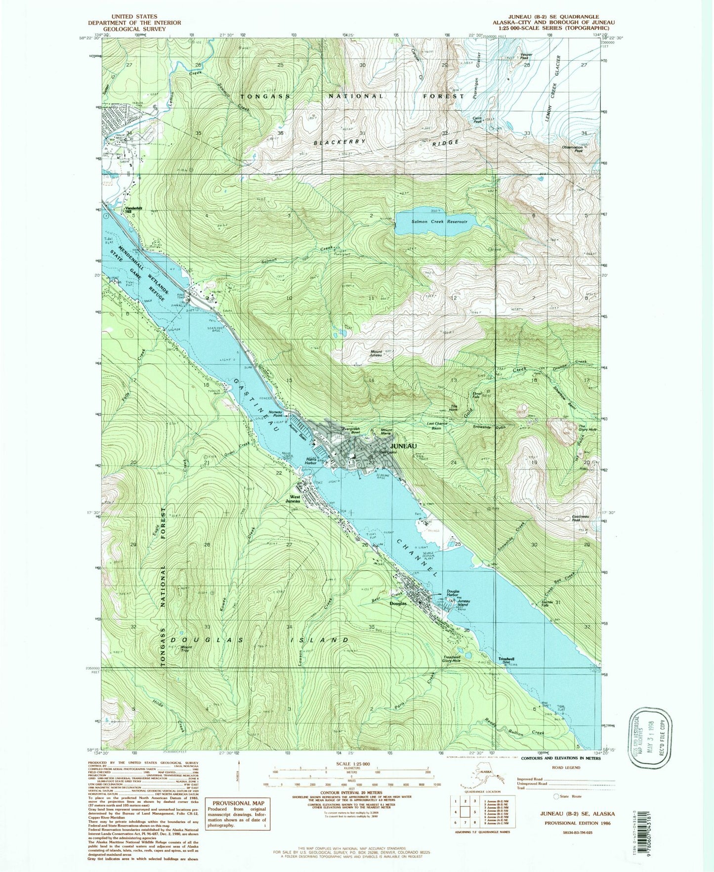
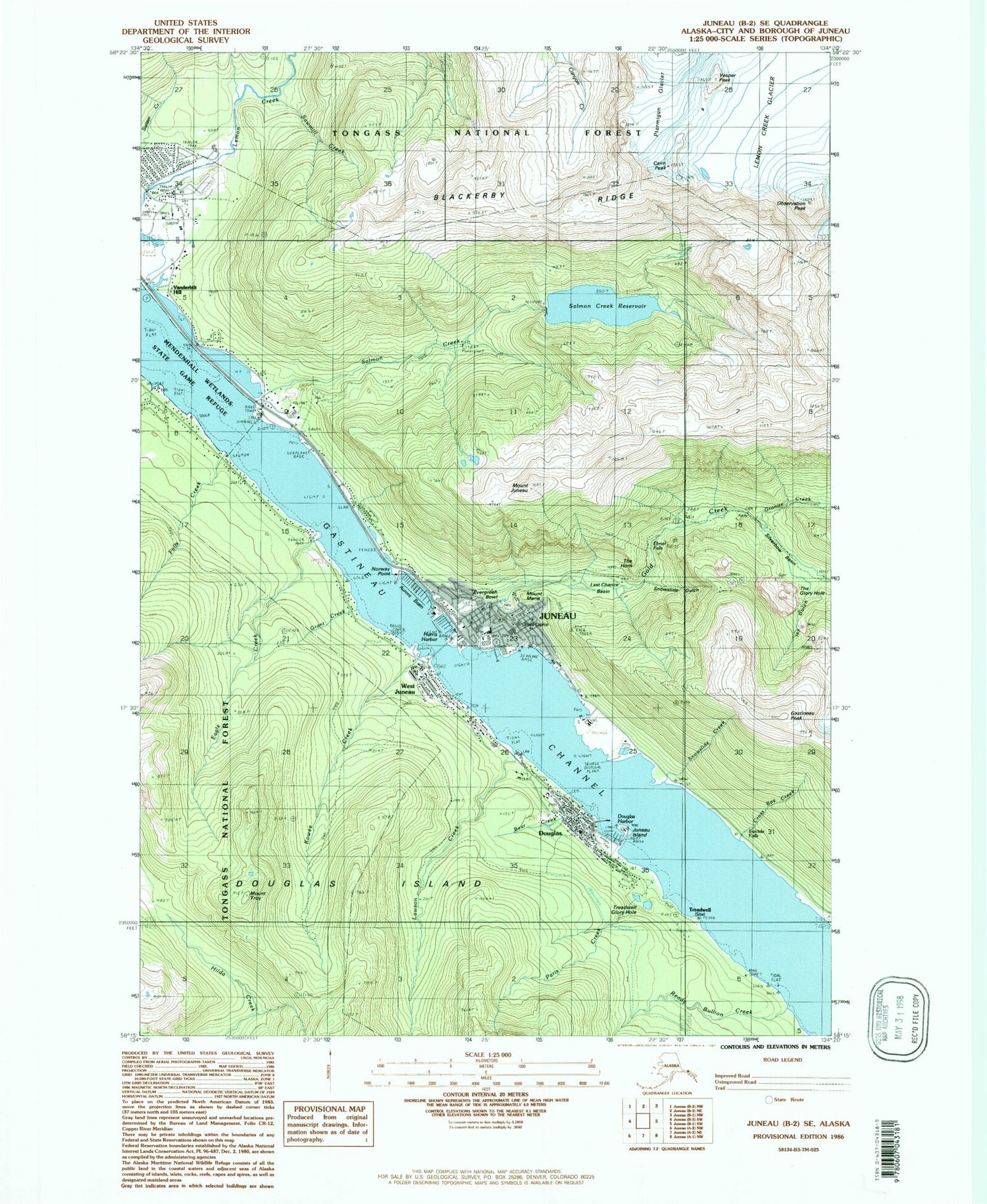
Classic USGS Juneau B-2 SE Alaska 7.5'x7.5' Topo Map
Couldn't load pickup availability
Historical USGS topographic quad map of Juneau B-2 SE in the state of Alaska. Typical map scale is 1:24,000, but may vary for certain years, if available. Print size: 24" x 27"
This quadrangle is in the following counties: Juneau.
The map contains contour lines, roads, rivers, towns, and lakes. Printed on high-quality waterproof paper with UV fade-resistant inks, and shipped rolled.
Contains the following named places: Alaska-Juneau Mill, Bear Creek, Blackerby Ridge, Cairn Peak, Cross Bay Creek, Douglas, Eagle Creek, Ebner Falls, Evergreen Bowl, Falls Creek, Gastineau Channel, Gastineau Peak, Gold Creek, Granite Creek, Grant Creek, Icy Gulch, Juneau, Juneau Island, Mount Juneau, Kowee Creek, Last Chance Basin, Lawson Creek, Mount Maria, Moller Ski Trail, Mount Roberts Trail, Neilson Creek, Norway Point, Observation Peak, Paris Creek, Ptarmigan Glacier, Quartz Gulch (historical), Ready Bullion Creek, Salmon Creek, Salmon Creek Dam, Sawmill Creek, Silverbow Basin, Slalom Cabin (historical), Snowslide Creek, Snowslide Gulch, Suicide Falls, The Glory Hole, The Horn, Treadwell (historical), Treadwell Ditch, Treadwell Glory Hole, Mount Troy, Dan Moller Cabin, Vanderbilt Hill, Vesper Peak, West Juneau, Lemon Creek, Douglas Harbor, Douglas Island Reservoir Dam, KJNO-AM (Juneau), KINY-AM (Juneau), KAJD-AM (Juneau), KTOO-FM (Juneau), KSUP-FM (Juneau), KTKU-FM (Juneau), KJUD-TV (Juneau), KTOO-TV (Juneau), Juneau Harbor Seaplane Base, North Douglas Heliport, Salmon Creek Reservoir, Starr Hill, Starr Hill, Court House Hill, Alaska Chief Falls, Bulger Hill, Canyon Ridge, Chicken Ridge, Dix Gulch, Gold Creek Valley, Groundhog Creek (historical), Gull City, Ice Creek, Impregnable Basin, Jamestown Hill, Juneau Harbor, Juneau Ridge, New Boston (historical), Nugget Gulch, Perseverance, Ptarmigan Ridge, Quartz Glacier, Salmon Creek Divide, Salmon Ridge, Tsantikihin (historical), Aurora Basin, Harris Harbor, Douglas Alaska Native Village Statistical Area, Barlett Regional Hospital Heliport, Lemon Creek Pit, Capital City Fire and Rescue Downtown Juneau Station, Capital City Fire and Rescue Douglas Station, Chicken Ridge Historic District, Juneau Downtown Historic District, Bartlett Regional Hospital, Southeast Alaska Regional Health Consortium Ethel Lund Medical Center, Bartlett Regional Hospital - Rainforest Recovery Center, Juneau Women Infants and Children Clinic, Juneau Family Birth Center, Juneau Public Health Center - Southeast Region, Southeast Alaska Regional Health Consortium Front Street Clinic, Valley Medical Care, Alaska State Capitol, Douglas Post Office, Kindred Post Postal Station, Federal Station Post Office, United States Marshal's Service Juneau, Lemon Creek Correctional Center, Johnson Youth Center, Evergreen Cemetery, Catholic Cemetery, Douglas Indian Cemetery, Eagles Cemetery