
MyTopo
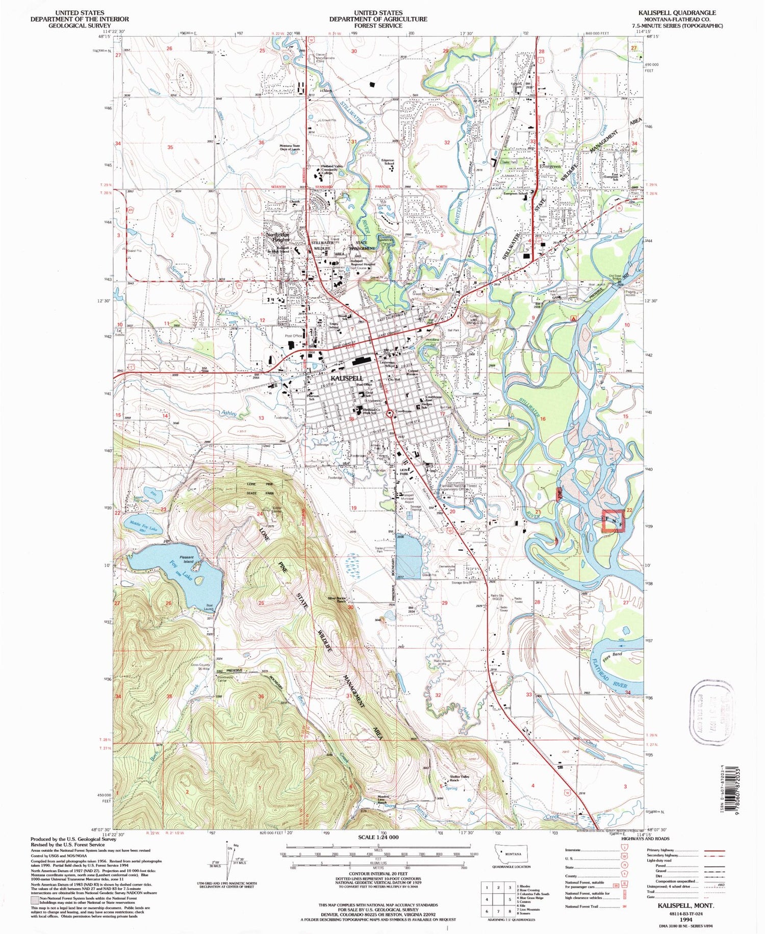
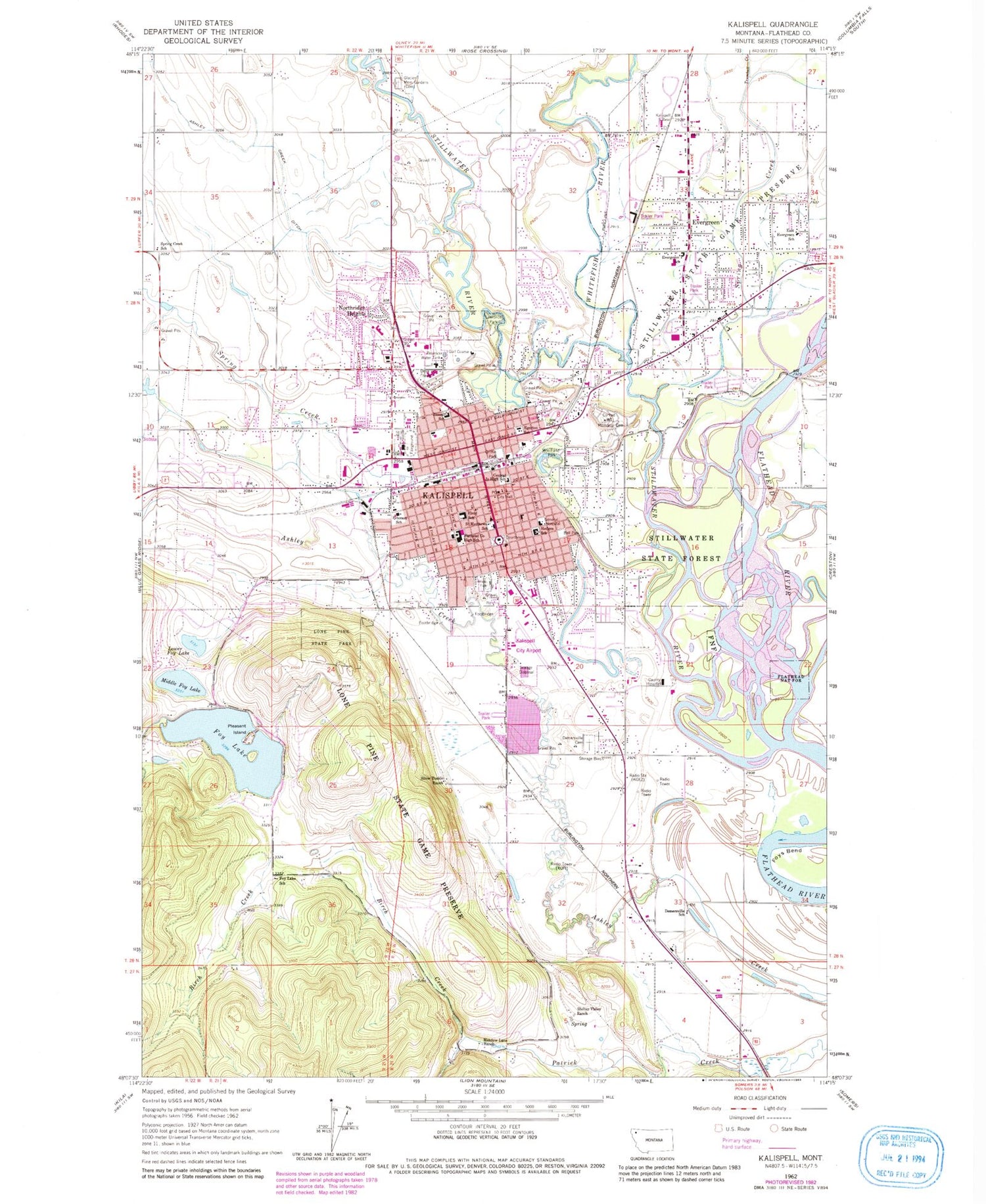
Classic USGS Kalispell Montana 7.5'x7.5' Topo Map
Couldn't load pickup availability
Historical USGS topographic quad map of Kalispell in the state of Montana. Map scale may vary for some years, but is generally around 1:24,000. Print size is approximately 24" x 27"
This quadrangle is in the following counties: Flathead.
The map contains contour lines, roads, rivers, towns, and lakes. Printed on high-quality waterproof paper with UV fade-resistant inks, and shipped rolled.
Contains the following named places: 08N21W04DCDA01 Well, 27N21W04AD__01 Well, 27N21W05BA__01 Well, 28N21W03AB__01 Well, 28N21W03AC__01 Well, 28N21W03BB__01 Well, 28N21W03BCDB01 Well, 28N21W03BCDB02 Well, 28N21W03CB__01 Well, 28N21W04AC__01 Well, 28N21W04BC__01 Well, 28N21W04BD__01 Well, 28N21W04CB__01 Well, 28N21W04DC__01 Well, 28N21W05CB__01 Well, 28N21W05CB__02 Well, 28N21W05DD__01 Well, 28N21W06BA__01 Well, 28N21W06CDBD01 Well, 28N21W07BB__01 Well, 28N21W07DDBD01 Well, 28N21W08AA__01 Well, 28N21W08CDAA01 Well, 28N21W08DD__01 Well, 28N21W08DDDD01 Well, 28N21W09AA__01 Well, 28N21W09BA__01 Well, 28N21W10CD__01 Well, 28N21W16CB__01 Well, 28N21W17AD__01 Well, 28N21W17DD__01 Well, 28N21W17DD__02 Well, 28N21W19AA__01 Well, 28N21W19AA__02 Well, 28N21W19BB__01 Well, 28N21W19BB__02 Well, 28N21W19BC__01 Well, 28N21W19BC__02 Well, 28N21W19DD__01 Well, 28N21W20AA__01 Well, 28N21W20BA__01 Well, 28N21W20BBAD01 Well, 28N21W20BBCB01 Well, 28N21W20DA__01 Well, 28N21W20DB__01 Well, 28N21W20DB__02 Well, 28N21W20DD__01 Well, 28N21W27AB__01 Well, 28N21W27CC__01 Well, 28N21W28BB__01 Well, 28N21W28DB__01 Well, 28N21W29ABDC01 Well, 28N21W29ACBB01 Well, 28N21W29BC__01 Well, 28N21W29BC__02 Well, 28N21W29CC__01 Well, 28N21W30BD__01 Well, 28N21W30DD__01 Well, 28N21W33BB__01 Well, 28N21W33CD__01 Well, 28N21W33CD__02 Well, 28N21W34BC__01 Well, 28N21W34CB__01 Well, 28N22W01AD__01 Well, 28N22W01BC__01 Well, 28N22W01CC__01 Well, 28N22W01DC__01 Well, 28N22W01DD__01 Well, 28N22W01DD__02 Well, 28N22W01DD__03 Well, 28N22W02BC__01 Well, 28N22W11CA__01 Well, 28N22W11CD__01 Well, 28N22W11DA__01 Well, 28N22W11DA__02 Well, 28N22W12CB__01 Well, 28N22W12CC__01 Well, 28N22W12DC__01 Well, 28N22W13BA__01 Well, 28N22W14AB__01 Well, 28N22W23AB__01 Well, 29N20W20CA__01 Well, 29N21W27CD__01 Well, 29N21W27DBAC01 Well, 29N21W27DBAC02 Well, 29N21W28AB__01 Well, 29N21W28CB__01 Well, 29N21W28CB__02 Well, 29N21W28CC__01 Well, 29N21W28CD__01 Well, 29N21W28DB__01 Well, 29N21W28DC__01 Well, 29N21W30CB__01 Well, 29N21W30CC__01 Well, 29N21W30CD__01 Well, 29N21W32AA__01 Well, 29N21W32AB__01 Well, 29N21W32CC__01 Well, 29N21W32DD__01 Well, 29N21W32DD__02 Well, 29N21W32DD__03 Well, 29N21W33AA__01 Well, 29N21W33AA__02 Well, 29N21W33AAAB01 Well, 29N21W33AD__01 Well, 29N21W33BD__01 Well, 29N21W33CB__01 Well, 29N21W33CCC_01 Well, 29N21W33CD__01 Well, 29N21W33DA__01 Well, 29N21W33DB__01 Well, 29N21W33DB__02 Well, 29N21W34CA__01 Well, 29N21W34CA__02 Well, 29N21W34CB__01 Well, 29N21W34CC__01 Well, 29N21W34CC__02 Well, 29N21W34CD__01 Well, 29N21W34CD__02 Well, 29N22W25AD__01 Well, 29N22W25CB__01 Well, 29N22W35BB__01 Well, 29N22W35DD__01 Well, 29N22W35DD__02 Well, 29N22W35DDDA01 Well, 29N22W36BC__01 Well, 29N22W36BCBD01 Well, 29N22W36DA__01 Well, A Chiropractic Clinic, Airport Fields, Alpine Mobile Manor, Archie Roe Field, Ashley, B and B Shopping Center, Balls Crossing, Begg Park, Big Sky Family Medicine, Birch Creek, Braidwater Farm Airport, Brendan House Skilled Nursing, Buffalo Hill Golf Club, Carlson Chiropractic Offices, City of Kalispell, Conrad Memorial Cemetery, Daley Softball Fields, Demersville, Demersville Cemetery, Depot Park, Dry Bridge Park, Duncan, East Evergreen Mobile Home Park, East Side Historic District, Equity Supply Company Elevator, Evergreen, Evergreen Census Designated Place, Flathead County Fairgrounds, Flathead County Hospital, Foy Lake, Foy Lake Cross Country Ski Area, Foys Bend, Friendship House Adult Care, Gallagher Park, Gateway West Mall, General Hospital, Glacier Memorial Gardens, Glacier Pines RV Park, Grand View Park, Greenwood Village Campground, Griffin Park, Haven Field, Hawthorne Park, Heritage Park, Heritage Place, Herron Park, Immanuel Lutheran Home, Japanese Hospital, Kalispell, Kalispell Center Mall, Kalispell City Airport, Kalispell Division, Kalispell Eye Clinic Incorporated, Kalispell Lakers Field, Kalispell Regional Hospital Heliport, Kalispell Regional Medical Center, Kalispell-Somers Railroad Spur Line Historical Marker, KGEZ-AM (Kalispell), Kiwanis Lane Picnic Area, KOFI-AM (Kalispell), KOFI-FM (Kalispell), Lawrence Park, Lion Park, Lone Pine State Park, Lone Pine State Preserve, Lower Foy Lake, Macdonald Hospital, Mar-Le Villa, Meadow Lane Ranch, Meadow Manor Incorporated, Meadowlark Mobile Home Park, Meridian Park, Middle Foy Lake, Montana State Department of Lands, Mountain View Mobile Home Park, Northern Pines Golf Club, Northridge Heights, Northridge Park, Old Steel Bridge, Old Steel Bridge Fishing Access Site, Orchard Park, Park View Terrace, Parkdale, Pleasant Island, Ridgewood Terrace, Russell School, Shady Lane Mobile Home Park, Shelter Valley Ranch, Silver Buckle Ranch, Somers Junction, Spring Creek, Spruce Park RV Park, Stillwater River, Stillwater Slough, Stillwater State Game Perserve, Sunset Park, Thompson Field, Trumbull Creek, Twin Acres Mobile Home Park, Valley Chiropractic Center, Village Greens Golf Course, Washington Street Park, White Birch RV and Campground, Whitefish River, Willow Creek Mobile Home Park, Windward Place, Woodland Park


