MyTopo
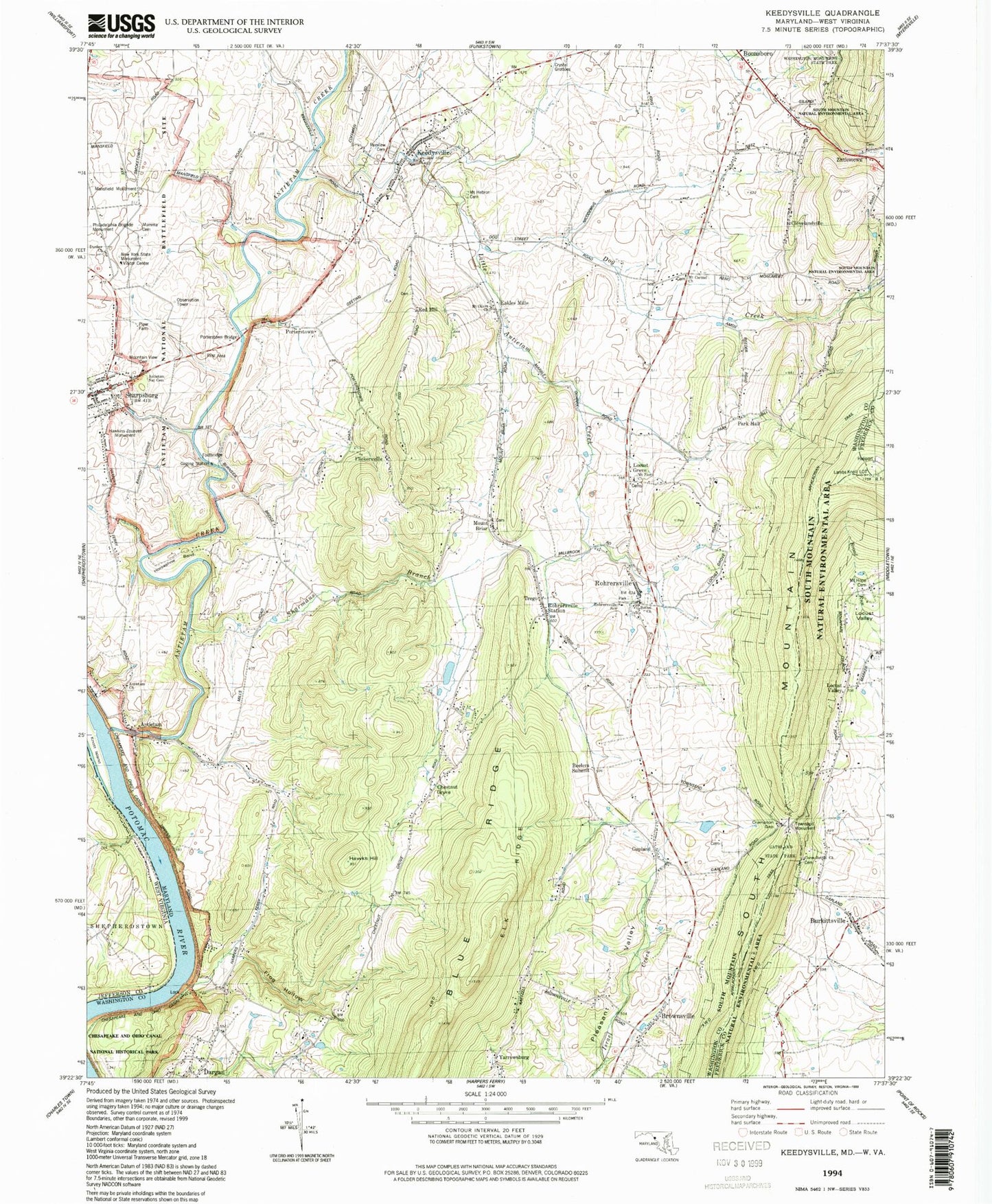
USGS Classic Keedysville Maryland 7.5'x7.5' Topo Map
Couldn't load pickup availability
Historical USGS topographic quad map of Keedysvillein the states of Maryland, Pennsylvania. Scale: 1:31680. Print size: 24" x 27"
This quadrangle is in the following counties: Frederick, Jefferson, Washington.
The map contains contour lines, roads, rivers, towns, lakes, and grids including latitude / longitude and UTM / MGRS. Printed on high-quality waterproof paper with UV fade-resistant inks.
Contains the following named places: Antietam, Antietam Church of God, Antietam National Cemetery, Bethel United Methodist Church, Gathland State Park, Ceres-Bethel Church, Crampton Gap, Dog Creek, Dunker Church, Elk Ridge, Fairview Cemetery, Frog Hollow, Hawkins Zouaves Monument, Hawks Hill, Horseshoe Bend, Keedysville, Knott Island, Little Antietam Creek, Locust Grove, Mansfield Monument, Mount Carmel United Methodist Church, Mount Hebron Cemetery, Mount Hope Cemetery, Mount Olives Church, Mount Zion Lutheran Church, Mountain View Cemetery, Mumma Cemetery, New York State Monument, Philadelphia Brigade Monument, Piper Farm, Porterstown Bridge, Sharmans Branch, Sharpsburg, Townsend Monument, Washington Monument State Park, Appletown, Lambs Knoll, Beelers Summit, Locust Valley, Antietam National Battlefield, Brownsville, Burkittsville, Chestnut Grove, Clevelandville, Dargan, Eakles Mills, Flickersville, Gapland, Mount Briar, Park Hall, Porterstown, Red Hill, Trego, Antietam Creek, Lambs Knoll Look Out Tower, Rohrersville, Rohrersville Station, Rohrersville School, Burkittsville Union Cemetery, Burkittsville Post Office, Evangelical Reformed Church, Lamb Knolls, Lambs Old Field, Mount Hope Church of God, Saint Paul Lutheran Church, Church of God, Church of God Cemetery, Keedysville Spring, Sharpsburg Spring, Yourtee Spring, Antietam Creek Aqueduct, Antietam Creek Campground, Antietam Dargan Community Park, Antietam Heights, Antietam Iron Works (historical), Bent Willow Farm, Bloody Lane, Brownsville Post Office (historical), Burnside Acres, Christ Reformed Church, Dargan Bend, East Woods (historical), Forge Hill Estates, Gapland Post Office (historical), Harvest Acres, Hicks Bridge, Horse Shoe Bend, Keedysville Post Office, Little Antietam Medical Center, Lock 37, Lower Bridge, Maryland Monument, McClellans Lookout, Mount Briar Cemetery, Mount Briar Wetlands Reserve, Mount Carmel, Mount Carmel Graveyard, Mount Vernon Evangelical and Reformed Church, Mountain Lock Campground, North Woods (historical), Park Hall Estates, Pleasant Valley, Potomac Vistas, Prys Mill (historical), Red Hill, Rohersville Cemetery, Rohrersville Post Office, Saint Pauls Evangelical Lutheran Church, Salem United Methodist Church, Sharpsburg Post Office, Sharpsburg Public Library, Sharpsburg Town Hall, Snavelys Ford Trail, Snavelys Ford, South County Park, Springvale, Taylor Heights, Taylor Park, The Cornfield, The Lookout, Wades Landing, West Woods (historical), District 1 Sharpsburg, District 19 Keedysville, District 8 Rohrersville, Pry Ford, Boonsboro Volunteer Fire Company 8 Substation, Rohrersville Census Designated Place, Town of Burkittsville, Town of Keedysville, Town of Sharpsburg, Double H Farms, Sharpsburg Reformed Cemetery, Antietam Census Designated Place, Brownsville Census Designated Place, Dargan Census Designated Place, Gapland Census Designated Place, Trego-Rohrersville Station Census Designated Place, Yarrowsburg Census Designated Place, Mount Briar Census Designated Place, Eakles Mill Census Designated Place, Char Mar Dairy Farm, Houris Falls, Coatsville, Antietam Creek