
MyTopo
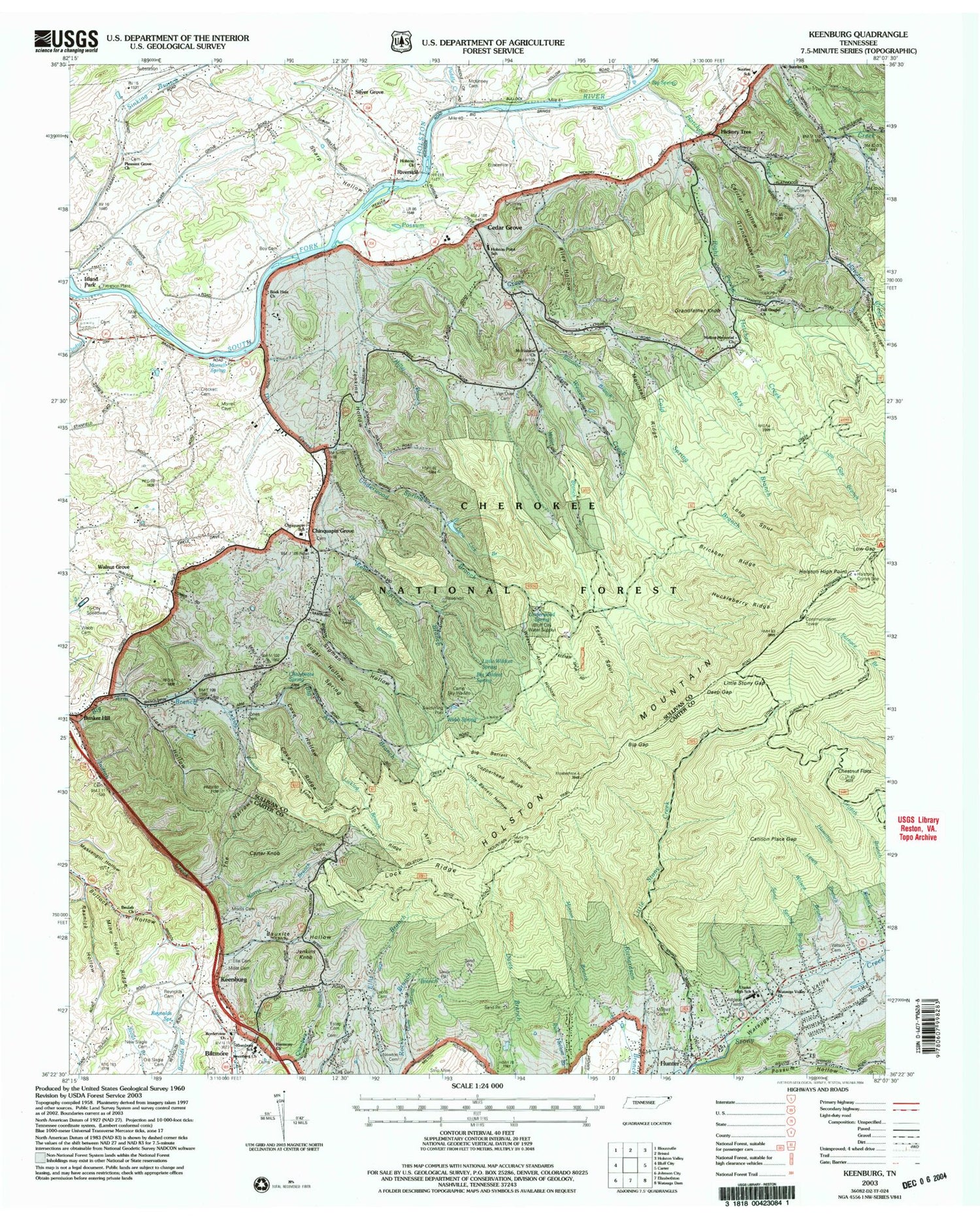
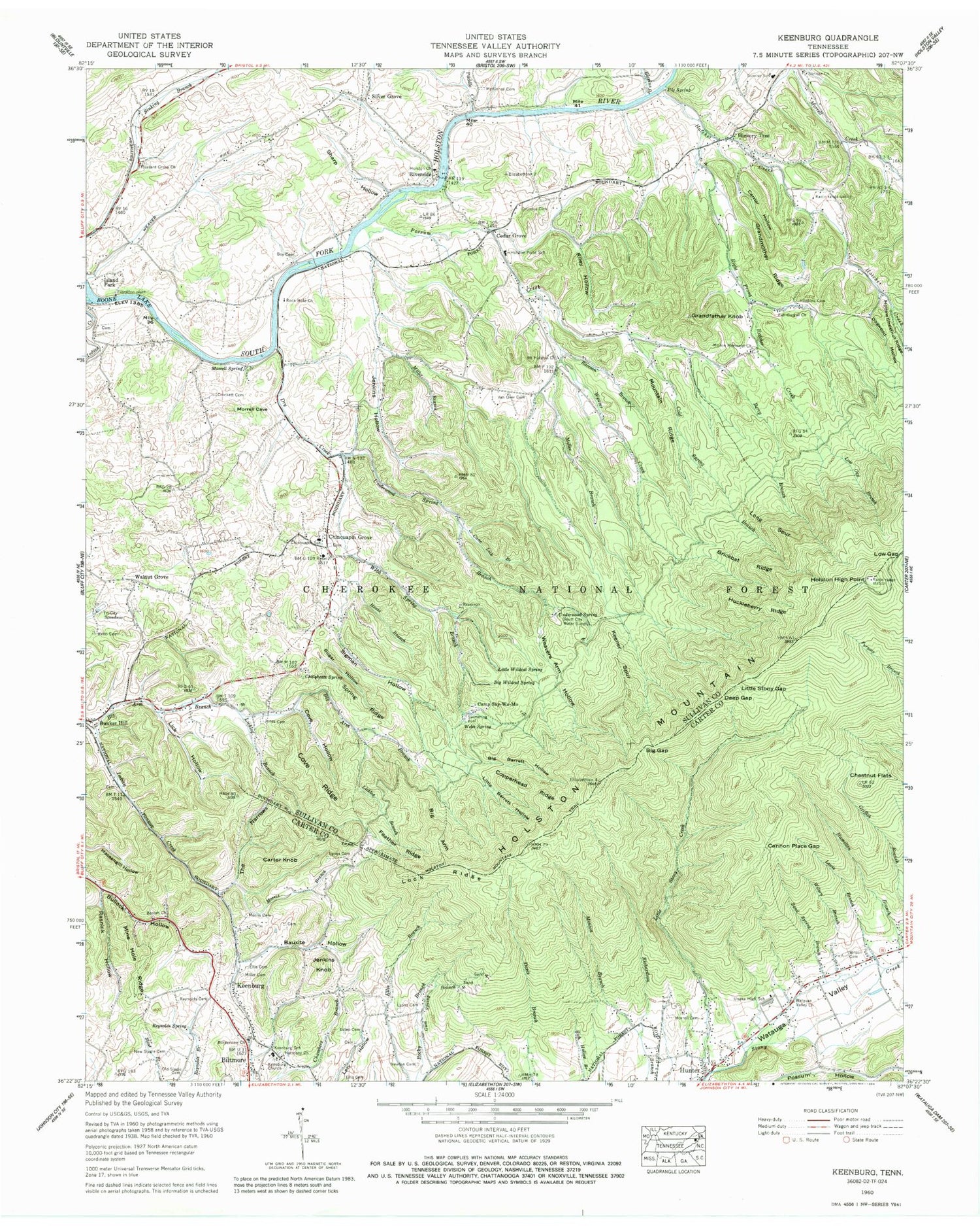
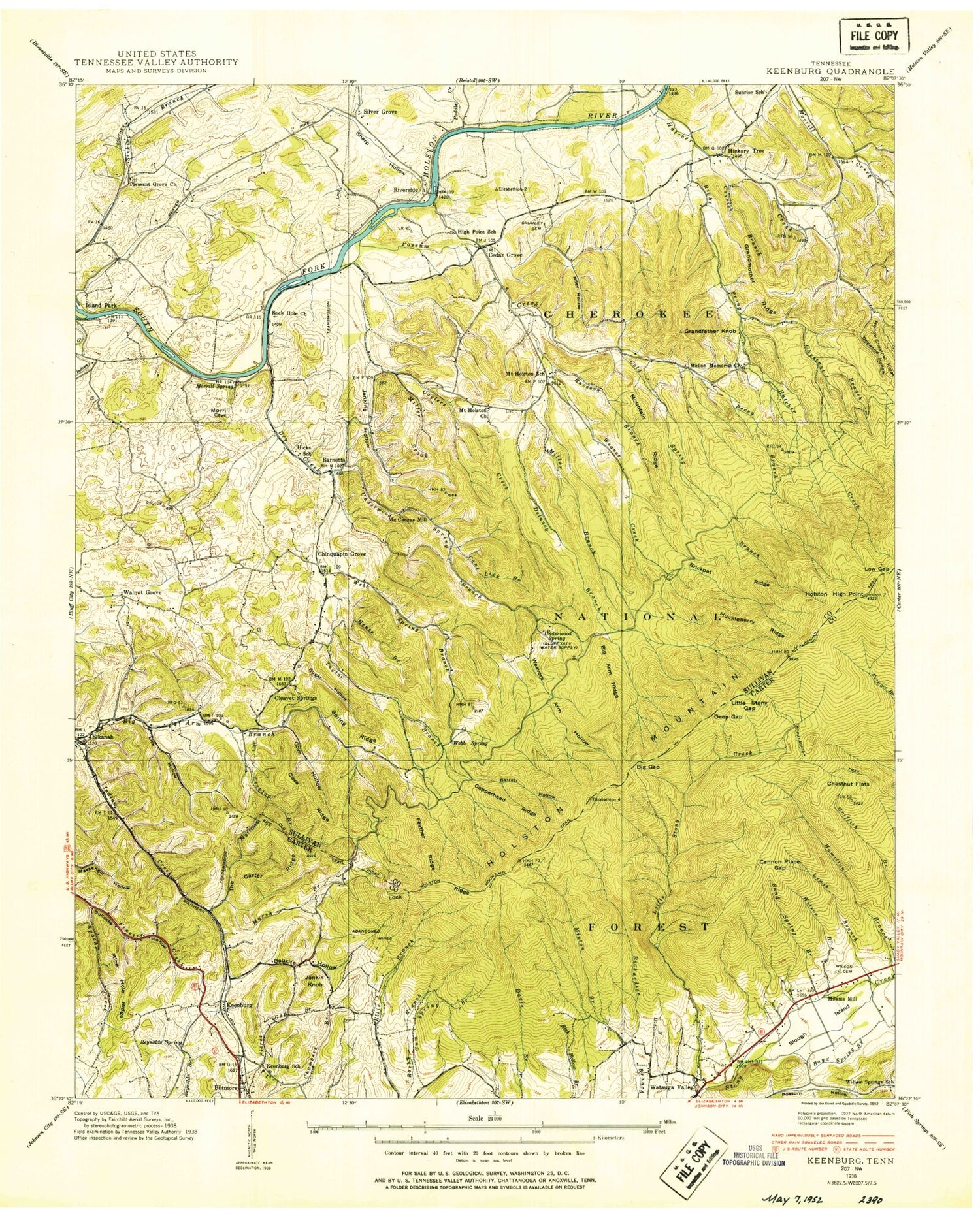
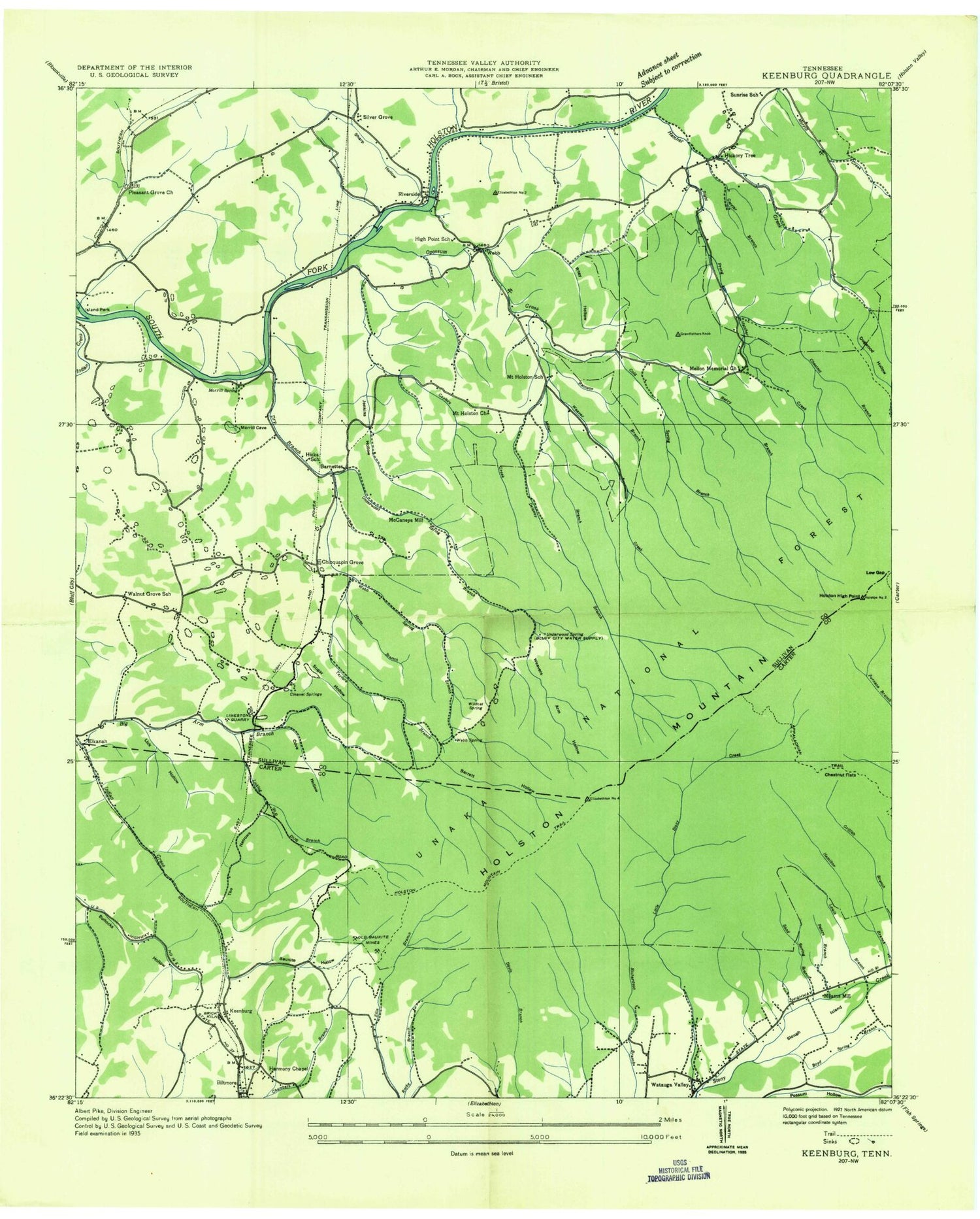
Classic USGS Keenburg Tennessee 7.5'x7.5' Topo Map
Couldn't load pickup availability
Historical USGS topographic quad map of Keenburg in the state of Tennessee. Map scale may vary for some years, but is generally around 1:24,000. Print size is approximately 24" x 27"
This quadrangle is in the following counties: Carter, Sullivan.
The map contains contour lines, roads, rivers, towns, and lakes. Printed on high-quality waterproof paper with UV fade-resistant inks, and shipped rolled.
Contains the following named places: Barnetts, Bauxite Hollow, Berry Branch, Beulah Church, Big Arm, Big Arm Branch, Big Barrett Hollow, Big Gap, Big Spring, Big Wildcat Spring, Blevins Branch, Bluff City-Piney Flats Division, Borderview Church, Boy Cemetery, Boyd Spring Branch, Brickbat Ridge, Bunker Hill, Bunker Hill Christian Church Cemetery, Camp Sky-Wa-Mo, Cane Lick Branch, Cannon Place Gap, Carrier Branch, Carrier Hollow, Carter Knob, Caylers Creek, Cedar Grove, Chalybeate Spring, Chestnut Branch, Chestnut Flats, Chinkapin Grove Church, Chinquapin Elementary School, Chinquapin Grove, Chinquapin Grove Baptist Church Cemetery, Cleavet Springs, Cold Spring Branch, Copperhead Ridge, Cove Hollow, Cove Ridge, Crockett Cemetery, Crumley Cemetery, Deep Gap, Delaney Branch, Dogwood Hollow, Dry Creek, Ellis Cemetery, Estep Cemetery, Feather Ridge, Full Gospel Church, Grandfather Knob, Grandmother Ridge, Gum Spring Branch, Hamilton Branch, Harmony Church, Hatcher Creek, Hense Branch, Hickory Tree, Hickory Tree Volunteer Fire Department, Hicks School, High Point School, Hollow Chestnut Ridge, Holston Church, Holston High Point, Holston Point School, Holston VOR, Hopkins Cemetery, Huckleberry Ridge, Hunter Census Designated Place, Island Park, Jenkins Hollow, Jenkins Knob, Jones Cemetery, Keenburg, Keenburg Church, Keenburg Elementary School, Keener Spur, Lewis Branch, Lick Hollow, Licklog Branch, Little Barrett Hollow, Little Branch, Little Stony Creek, Little Stony Creek Mine, Little Stony Gap, Little Wildcat Spring, Lock Ridge, Long Spur, Low Gap Branch, Low Gap Campground, Lyons Cemetery, McCaneys Mill, McCorkles Mill, McKinney Cemetery, Mellon Memorial Church, Milams Mill, Miller Branch, Miller Cemetery, Mine Hole Ridge, Minton Branch, Morrell Cemetery, Morrell Spring, Morris Branch, Morris Cemetery, Mount Holston Church, Mount Holston School, Mountain Ridge, New Slagle Cemetery, Newton Cemetery, Old Dug Trail, Old Slagle Cemetery, Paddle Creek, Pleasant Grove Cemetery, Pleasant Grove Church, Possum Creek, Raccoon Branch, Rasnick Hollow, Red Bird Hill Mine, Reynolds Cemetery, Reynolds Spring, Right Prong Hatcher Creek, Riley Cemetery, Riley Hollow, Riverside, Rock Hole Church, Sand Spring Branch, Sharp Hollow, Sigman Hollow, Silver Grove, Slough Island, Spring Ridge, Stovers Mill, Sugar Hollow, Sullivan East High School, Sunrise Church, Sunrise School, Taylor Branch, The Narrows, Tin Can Hollow, Tri-City Speedway, Turkeytown Mine, Unaka High School, Underwood Park Dam, Underwood Park Lake, Underwood Spring, Underwood Spring Branch, Underwood Springs, Van Over Cemetery, Walnut Grove, Walnut Grove School, Watauga Mine, Watauga Valley, Watauga Valley Church, Watauga Volunteer Fire Department Station 2, Weaver Creek, Weavers Arm Hollow, Weavers Arm Prospect, Webb Cemetery, Webb Spring, Webb Spring Branch, WETS-FM (Johnson City), WHCB-FM (Bristol), White Prospect, Willow Springs School, Wilson Branch, Wilson Cemetery, WJHL-TV (Johnson City), WKPT-TV (Kingsport), WXBQ-FM (Bristol) (TN-VA), ZIP Codes: 37618, 37643


