MyTopo
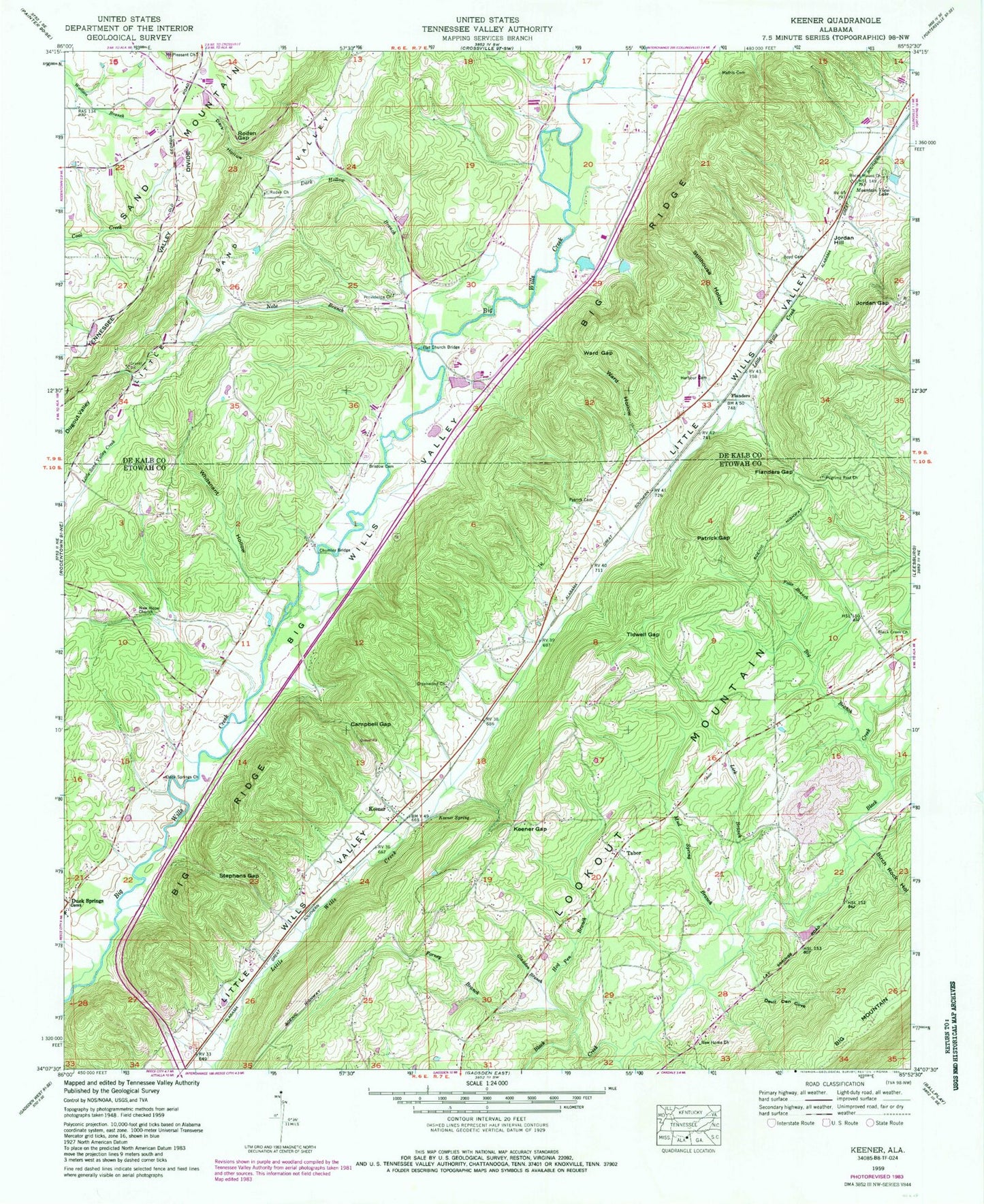
Classic USGS Keener Alabama 7.5'x7.5' Topo Map
Couldn't load pickup availability
Historical USGS topographic quad map of Keener in the state of Alabama. Map scale may vary for some years, but is generally around 1:24,000. Print size is approximately 24" x 27"
This quadrangle is in the following counties: DeKalb, Etowah.
The map contains contour lines, roads, rivers, towns, and lakes. Printed on high-quality waterproof paper with UV fade-resistant inks, and shipped rolled.
Contains the following named places: Big Branch, Birch Rock Hollow, Black Creek, Black Creek Missionary Baptist Church, Black Creek School, Black Creek Volunteer Fire Department, Boyd Cemetery, Bristow Cemetery, Bristow Methodist Episcopal Church, Campbell Gap, Carter School, Chumley, Chumley Bridge, Chumley Mill, Dark Hollow, Dark Hollow Branch, Devil Den Cove, Duck Springs, Duck Springs Baptist Church, Duck Springs Cemetery, Duck Springs Covered Bridge, Falls Branch, Flanders, Flanders Gap, Flat Church Bridge, Forney Branch, Gladden Branch, Greenwood, Greenwood Baptist Church, Greenwood Church Cemetery, Greenwood Post Office, Harbour Cemetery, Hendrixville, Hendrixville Volunteer Fire Department, Hog Pen Branch, John Gilbreath Number 1 Dam, John Gilbreath Number 1 Lake, Jordan Gap, Jordan Hill, Keener, Keener Baptist Church, Keener Elementary School, Keener Gap, Keener Spring, Keener Volunteer Fire Department, Lick Branch, Little Sand Valley Creek, Lookout Mountain Division, Marcus, Marcus School, Mathis Cemetery, Mount Pleasant Church, Mountain View Lake, Mud Spring Branch, New Home Missionary Baptist Church, New Hope Baptist Church, Nobe Branch, Patrick Cemetery, Patrick Gap, Pilgrims Rest Baptist Church, Pilgrims Rest Cemetery, Providence Church, Ray Smiths Lake, Rocky Mount Church, Roden Baptist Church, Roden Gap, Smith Dam, Smiths Bridge, Spring Branch, Stephens Bridge, Stephens Gap, Stillhouse Hollow, Tabor, Tabor Missionary Baptist Church, Tabor School, Tidwell Gap, Ward Gap, Ward Hollow, Whitsnant Hollow, Yancey Spring, Yancy