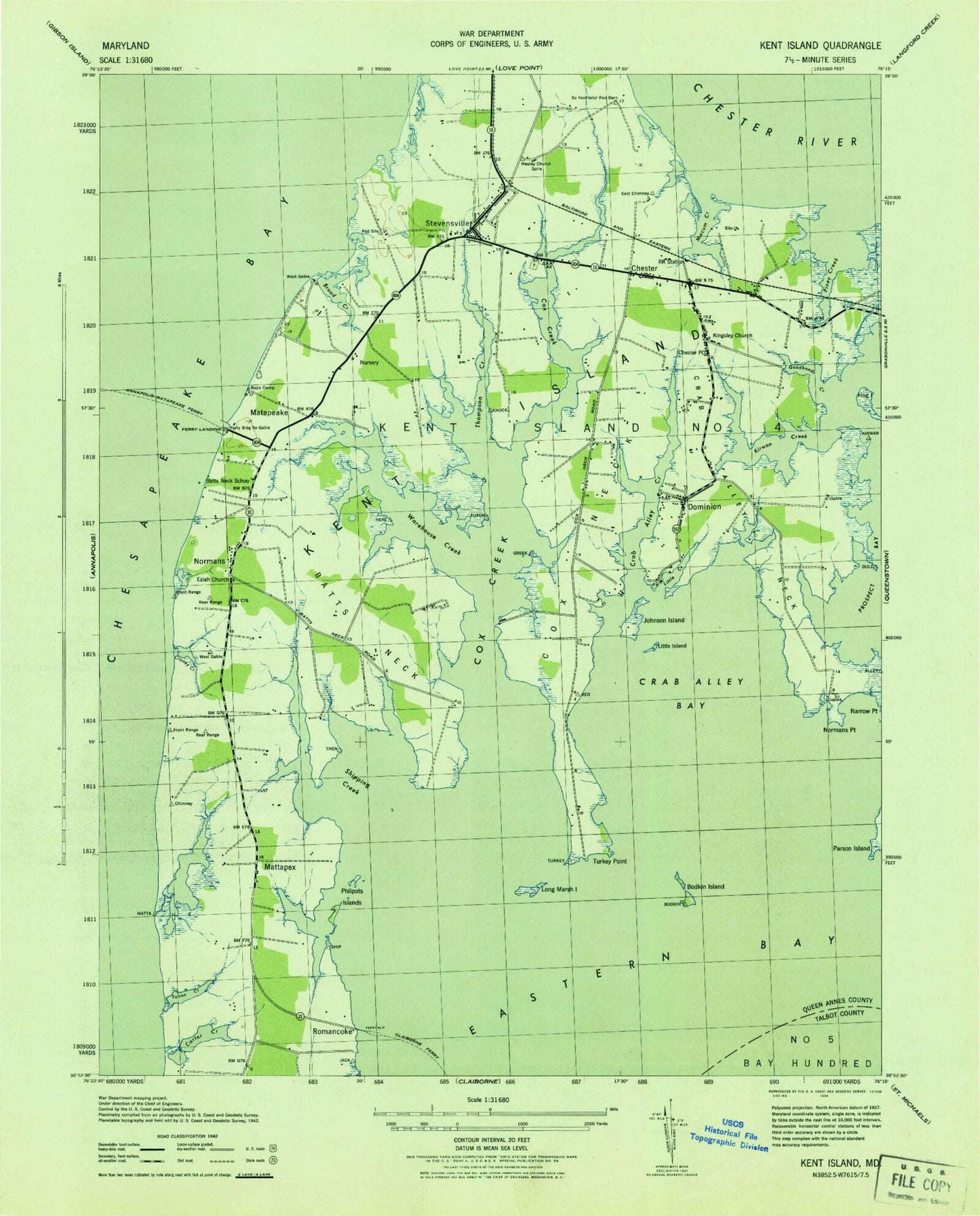
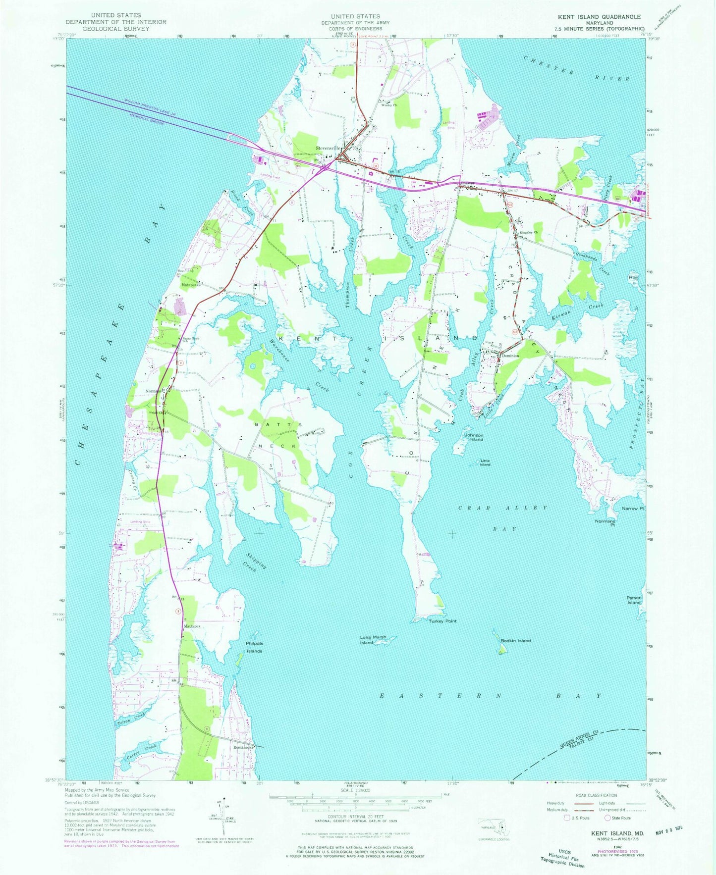
MyTopo
Classic USGS Kent Island Maryland 7.5'x7.5' Topo Map
Couldn't load pickup availability
Historical USGS topographic quad map of Kent Island in the state of Maryland. Typical map scale is 1:24,000, but may vary for certain years, if available. Print size: 24" x 27"
This quadrangle is in the following counties: Anne Arundel, Queen Anne's, Talbot.
The map contains contour lines, roads, rivers, towns, and lakes. Printed on high-quality waterproof paper with UV fade-resistant inks, and shipped rolled.
Contains the following named places: WBEY-FM (Grasonville), Blue Heron Golf Course, Bodkins Point, Butlers Landing, Chester Post Office, Claibornes Landing, Coxes Bay, Jones Hole, Kent Island Estates, Kent Timbers, Kentwood, Long Creek, Long Creek Farm, Mallard Point, Matapeakes Creek, Paradise Island, Parsons Point, Prices Creek, Queen Anne Colony, Romancoke on the Bay, Romancoke Pier, Romancoke Wharf County Park, Shipping Creek, Skipping Creek Plantation, Stevensville Post Office, Twin Cove Estates, Wiggins Corner, Baldwin Acres, Batts Neck Plantation, Bay City, Bentons Pleasure, Bridge Point, Bryans Cove, Calverton, Camp Wright, Lake Cardoza, Castle Marina, Chesapeake Bay Business Park, Chesapeake Estates, Cheslou Village, Chesterhaven Beach, Christ Episcopal Church, Church of God, Church of God, Cloverfields, Cox Creek Acres, Craney Creek Estates, Eastern Shore Outlets Shopping Center, Ezion Methodist Episcopal Cemetery, Ferry Landing, First Baptist Church, Galilee Lutheran Church, Gomoljak, Goose Point Estates, Harborview, Island View, Kangaroo Beach, Kent Cove, Kent Island Elementary School, Kent Island Shopping Center, Kent Island United Methodist Church, Kent Towne Market Shopping Center, Kirwans Landing, Little Chester Plaza Shopping Center, Maryland Marine Police Academy, Matapeake Estates, Matapeake State Park, Mowbray Park, Northeast Bay, Old Love Point Park, Old Point Estates, Queen Annes County Library - Kent Island Branch, Chester Regional Medical Center, Queens Landing, Red Apple Plaza Shopping Center, Saint Christophers Catholic Church, Sharktown, Shining Light Church, Southwind, Stevensville Historic District, Stevensville Middle School, Sunny Isle of Kent, Terrapin Beach Park, Thompson Creek Shopping Center, Union Wesley United Methodist Church, Walnut Shores, Watermans Business Park, Wesley Church, William Preston Lane Junior Memorial Bridge, Batts Neck, Batts Neck School, Bodkin Island, Broad Creek, Carter Creek, Chester, Cox Creek, Cox Neck, Crab Alley Bay, Crab Alley Creek, Crab Alley Neck, Craney Creek, Dominion, Eziah Church, Goodhands Creek, Hog Island, Johnson Island, Kent Island, Kingsley Church, Kirwan Creek, Little Creek, Little Island, Long Marsh Island, Macum Creek, Matapeake, Mattapex, Normans, Normans Point, Philpots Islands, Piney Creek, Romancoke, Shipping Creek, Stevensville, Thompson Creek, Tolson Creek, Turkey Point, Warehouse Creek, Marling Farms, South Prong Shipping Creek, Price Creek, Castle Marina Airport (historical), Kentmorr Airpark, Bay Bridge Airport, Kentmorr Marina, Christ Lutheran Church Cemetery, Kingsley Church Cemetery, Stevensville Cemetery, Union Wesley Methodist Church Cemetery, Wesley Cemetery, District 4 Kent Island, United Communities Volunteer Fire Department Station 9, Kent Island Volunteer Fire Department Station 1, Kent Island High School, Matapeake Elementary School, Bayside Elementary School, Christ Church Episcopal School, Chester Census Designated Place, Stevensville Census Designated Place, Bay Bridge Marina, Crab Alley Marina, Kent Landing Shopping Center, Cascia Vineyards, Maryland Natural Resource Police Department, Romancoke Census Designated Place