MyTopo
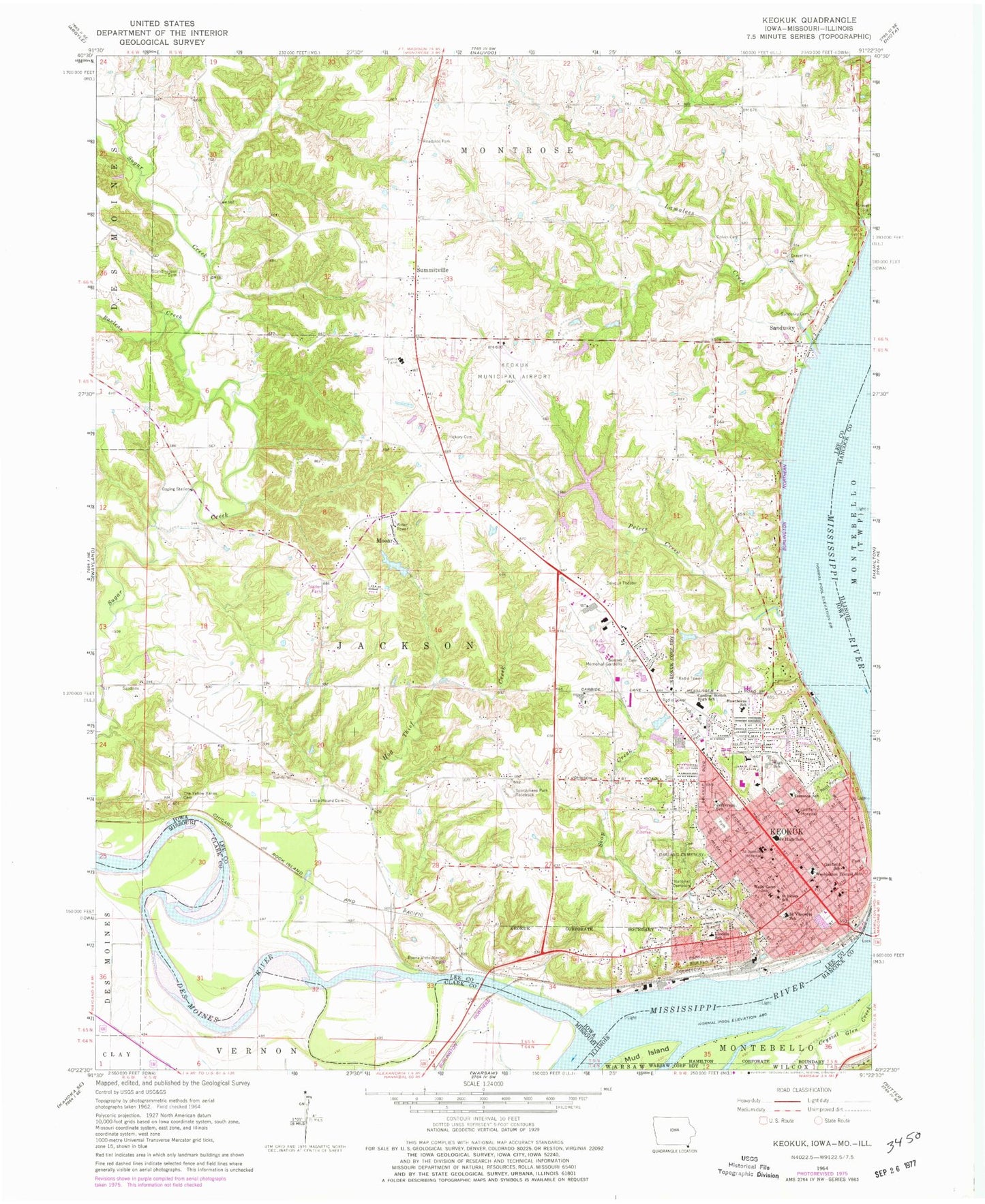
Classic USGS Keokuk Iowa 7.5'x7.5' Topo Map
Couldn't load pickup availability
Historical USGS topographic quad map of Keokuk in the states of Iowa, Illinois. Map scale may vary for some years, but is generally around 1:24,000. Print size is approximately 24" x 27"
This quadrangle is in the following counties: Clark, Hancock, Lee.
The map contains contour lines, roads, rivers, towns, and lakes. Printed on high-quality waterproof paper with UV fade-resistant inks, and shipped rolled.
Contains the following named places: All Saints Parish, American Eyecare Center, Apostolic Faith United Church, Assembly of God Church, Barlean Creek, Bel Air Baptist Church, Bethany Baptist Church, Bickel Stolport, Bluff Park, Buena Vista, Buena Vista Mound Cemetery, Calvary Baptist Church, Calvary Foursquare Church, Calvert Stadium, Cedar Glen Creek, Chatfield Park, Chief Keokuk Memorial Historical Marker, Christ Apostolic Church, Church of Christ, Church of New Beginnings, Church of the Nazarene, City of Keokuk, City of Keokuk Campground, Colvin Pioneer Cemetery, Crossview Fellowship, Deliverance Temple Pentecostal Church, Dudley Cemetery, Elks Fairview Golf Club, Emmanuel United Methodist Church, Evangelical Free Church, Faith Family Church, Faith Open Bible Fellowship, Family Worship Center, First Baptist Church, First Christian Church, First Lutheran Church, Garfield School, General Samuel Curtis Statue, George M Verity Riverboat Museum, George Washington Elementary School, Grand Theatre, Grape Creek, Hawthorne Elementary School, Hickory Grove Cemetery, Hickory Haven Campground, Hocker Estates Mobile Home Park, Hog Thief Creek, Jackson Township Fire Department, Jefferson School, Joseph Patterson Historical Marker, Joyce Park, Kah Heliport, KCBC-FM (Keokuk), Keokuk, Keokuk Catholic School, Keokuk Christian Academy, Keokuk Christian Science Society, Keokuk Clinic, Keokuk Convalescent Center, Keokuk Country Club, Keokuk Fire Department, Keokuk High School, Keokuk Middle School, Keokuk Municipal Airport, Keokuk National Cemetery, Keokuk Police Department, Keokuk Post Office, Keokuk Public Library, Keokuk Union Depot, Keokuk Wastewater Plant, Keosippi Mall, Kilbourne Park, KIMI-FM (Keokus), Kingdom Hall of Jehovah's Witnesses, Kiser Park, KOKX-FM (Keokuk), Lamalees Creek, Lee County Courthouse, Lee County Emergency Medical Services Keokuk, Lee County Farm, Lincoln School, Little Mound Cemetery, McDowell Lake Dam One, Messiah Lutheran Church, Mooar, Mooar Census Designated Place, Mooar Post Office, Mud Island, New Bethel Church of Keokuk, New Testament Christian Church, Oakland Cemetery, Observation Deck, Oiler Family Cemetery, Orthopedic Office of Keokuk, Pilgrim Rest Baptist Church, Prices Creek, Rand Park, Red Wing Access, Rees Park, Reorganized Church of Jesus Christ of Latter Day Saints, River Cities Ophthalmology Center, Riverview Park, Saint John's Church, Saint Josephs Hospital, Saint Paul United Church, Saint Peters School, Saint Vincents School, Samuel F Miller House Museum, Samuel Freeman Miller State Historical Marker, Sandusky, Sandusky Cemetery, Sandusky Census Designated Place, Sandusky Mobile Home Villa, Sandusky Post Office, Scandinavian Cemetery, Skyview Mobile Home Park, Soap Creek, Southeastern Community College - Keokuk Campus, Sportsman Park Racetrack, Sugar Valley Campground, Summitville, Summitville Post Office, Sunset Memorial Gardens, The Church of Jesus Christ of Latter Day Saints, Tolmie Park, Torrence School, Township of Jackson, Tri State Medical Group Center, Triangular Park, Trinity United Methodist Church, Tumelty Park, Turner Plot Cemetery, United Presbyterian Church, UnityPoint Health Keokuk Hospital, USS Maine Memorial Tablet Historical Marker, Victory Park, Vigen Memorial Home, Wells - Carey Elementary School, Yellow Banks Cemetery, ZIP Code: 52632