MyTopo
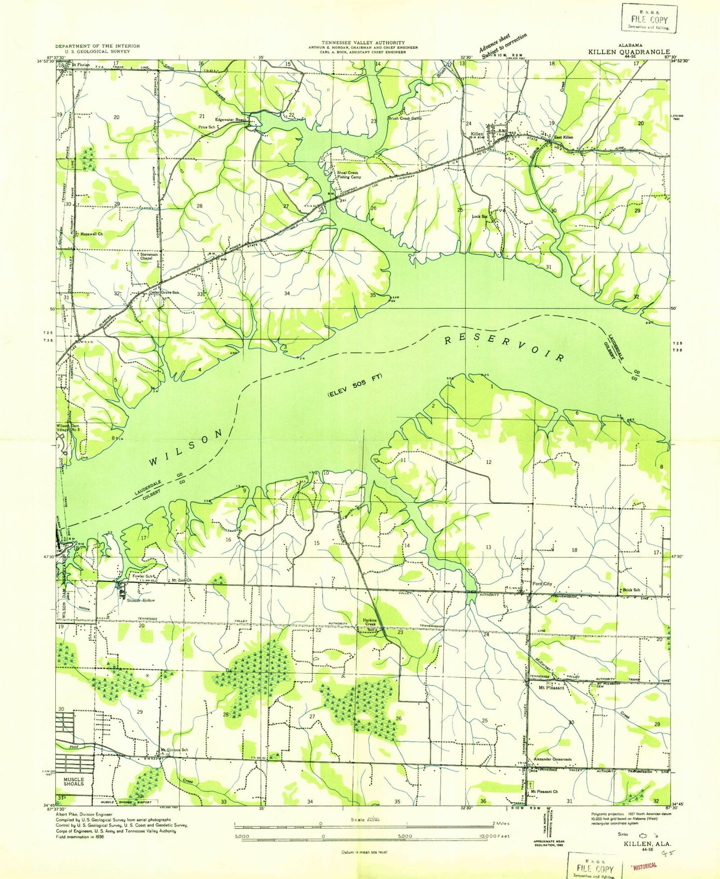
Classic USGS Killen Alabama 7.5'x7.5' Topo Map
Couldn't load pickup availability
Historical USGS topographic quad map of Killen in the state of Alabama. Map scale may vary for some years, but is generally around 1:24,000. Print size is approximately 24" x 27"
This quadrangle is in the following counties: Colbert, Lauderdale.
The map contains contour lines, roads, rivers, towns, and lakes. Printed on high-quality waterproof paper with UV fade-resistant inks, and shipped rolled.
Contains the following named places: Alabama Shores, Bainbridge, Bainbridge Eddy, Bainbridge Ferry, Bainbridge Post Office, Beech Grove Church of Christ, Bellemeade, Bible Baptist Church, Big Jump Bar, Big Muscle Shoals, Brick - Hatton Volunteer Fire Department, Brick Elementary School, Brooks Acres, Brooks School, Browns Chapel Methodist Church, Browns School, Brush Creek, Brush Creek Camp, Camp Hillcrest, Church of Christ, Davidsons Cross Roads, Detroit Park, Dry Bar, East Colbert Church, East Killen, Elm Acres, Emerald Beach Dock, Emerald Shores, Evergreen Estates, Fairview Church, Five Acre Island, Fleet Hollow, Florence Boulevard Missionary Baptist Church, Florence Fire Department Station 2, Ford City, Forty Acres Island, Fosters Mill, Four Mile School, Fowler Elementary School, Galloping Waters, Hatton Baptist Cemetery, Hawkins Cemetery, Hawkins Creek, Hawkins School, Hennigan Cemetery, Henson Spring, Hideaway Hills, Hopewell African Methodist Episcopal Church, Hopewell Cumberland Presbyterian Church, Hopewell School, Huff Cemetery, Indian Spring, Indian Springs, Jarman House Plantation, Jones Hill Cemetery, Kasmeier Pond, Kendale Gardens, Kernachan Cemetery, Killen, Killen Park, Killen Police Department, Killen Post Office, Killen Volunteer Fire Department, Kingman, Kingman Post Office, Kings Island, Lake Coves, Lakeside Acres, Lakeside Highlands, Lakeview, Lakeview Dock, Lakeview Heights, Lakeview Heights United Methodist Church, Lakeview Highlands, Landing Strip, Lauderdale Beach, Lee Heights Baptist Church, Lingerlost, Listerhill, Little Jump Bar, Little Muscle Shoals, Lock Number Eight, Lock Number Nine, Lock Number Seven, Lock Number Six, Lock Six, Lock Six Day Use Area, Lockland, Masonville, McKiernan Cemetery, McKiernan Creek, Mid - Lauderdale Volunteer Fire Department, Morningside Heights, Mount Olivia Church, Mount Olivious School, Mount Pleasant, Mount Pleasant Baptist Church, Mount Pleasant School, Mount Zion Cumberland Presbyterian Church, Muscle Shoals, Muscle Shoals Baptist Church, Muscle Shoals Canal, Muscle Shoals Fire Department Station 3, Muscle Shoals Headstart School, New Mount Zion African Methodist Episcopal Church Number 1, Nitrate City, Nitrate City Baptist Church, Nitrate City Church of Christ, Nitrate City Church of the Nazarene, Old Brick Presbyterian Church, Paradise Points, Pearsall Cemetery, Peden Cemetery, Peytona Points, Plainview Church of Christ, Polk Island, Poor Horse Bar, Price Branch, Price Cemetery, Price Spring, Raccoon Bar, Resting Island, Rivermont, Saint Florian, Saint Florian Branch, Saint Florian Police Department, Shegog Creek, Shegog Spring, Shoal Creek, Shoal Creek Aqueduct, Shoal Creek Bridge, Shoals Acres, Silver Shores Dock, Sixmile Creek, Sky Park, Skypark Golf Course, Sombrero Acres, Steenson Hollow, Steenson Marina, Steensons Mill, Stevenson Chapel, Tate - Russell Cemetery, Tate Slough, Tate Springs, Town of Killen, Town of Saint Florian, Turkey Chute Island, Turtle Point Yacht and Country Club, Underwood Crossroads, Victory Baptist Church, Village Pines, Virginia Shores, Walkers Quay, Webster Elementary School, Whitamore Cemetery, Wilson Heights, Wilson Lake, Wilson Lake Shores, Woodlawn, Woodlawn Church of Christ, ZIP Code: 35661