MyTopo
Classic USGS Kinlock Spring Alabama 7.5'x7.5' Topo Map
Couldn't load pickup availability
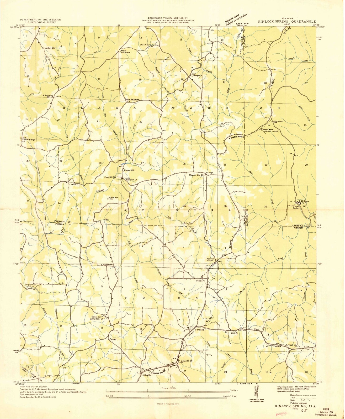
Historical USGS topographic quad map of Kinlock Spring in the state of Alabama. Map scale may vary for some years, but is generally around 1:24,000. Print size is approximately 24" x 27"
This quadrangle is in the following counties: Franklin, Lawrence, Winston.
The map contains contour lines, roads, rivers, towns, and lakes. Printed on high-quality waterproof paper with UV fade-resistant inks, and shipped rolled.
Contains the following named places: Allen Mill Creek, Bagwell Branch, Basin Creek, Bell Springs School, Bethlehem Church, Boiler Branch, Butler Falls, Butler Falls Branch, Buttram Gulf, Cagle Gulf, Camp Maxwell, Carroll Crossroads, Cat Den Branch, Center, Center School, Chenault Spring, Chenault Spring Branch, Chesnut Ridge, Chestnut Ridge, Chestnut Ridge Cemetery, Chilcoat Cemetery, Civilian Conservation Corps Camp Number F3, DeGraffenreid Cemetery, Dunn Branch, Ephesus Baptist Church, Ephesus Baptist Church Cemetery, Forkville, Frost Cemetery, Frost Chapel Church, Frost Pond, Haleyville Volunteer Fire Department Station 2, Hubbard Plantation, Hubbards Mill, J W Mayhall Lake Dam, Kinlock, Kinlock Falls, Kinlock Knob, Kinlock Lookout Tower, Kinlock Spring, Kirkpatrick Creek, Little Dice Branch, Littlesville Post Office, Littleville, Littleville Community Cemetery, Martintown, Maxwell Chapel United Methodist Church, Maxwell Chapel United Methodist Church Cemetery, Maxwell Creek, McGuire School, Meherg School, Natural Well Branch, New Bethlehem Church, New London Post Office, Old Bethlehem Church, Old Macedonia Baptist Church, Old Macedonia Cemetery, Orange, Orange Baptist Church, Orange Cemetery, Pebble, Pebble Junior High School, Pebble School, Pebble Volunteer Fire Department, Pleasant Site Church, Poplar Spring, Poplar Spring Cemetery, Posey Creek, Posey Field, Posey Mill, Posey Mill Cemetery, Posey Mill School, Quarter Creek, Quarter Creek Falls, Ridgecrest Church Camp, Saint Paul Cemetery, Saint Paul Church, Spring Lake, Stevensons Mill, Sunny Home Baptist Church Cemetery, Sunny Home Church, Swan Branch, Trapptown, Trapptown Junior High School, Union Hill Church, Upper Bear Creek Reservoir, Waldrop School, Whitehead Creek, Whitman Creek, Winston Memorial Cemetery