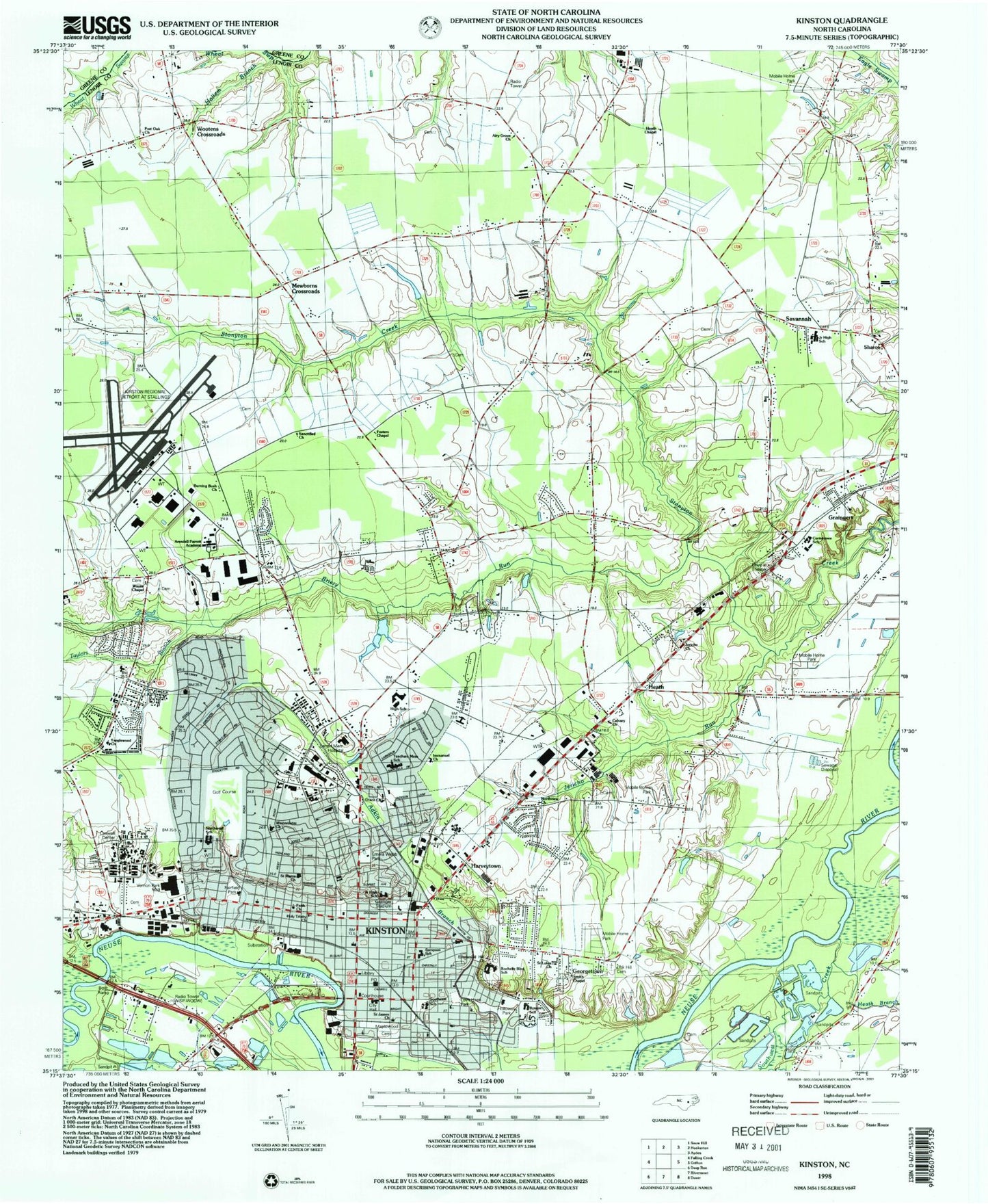
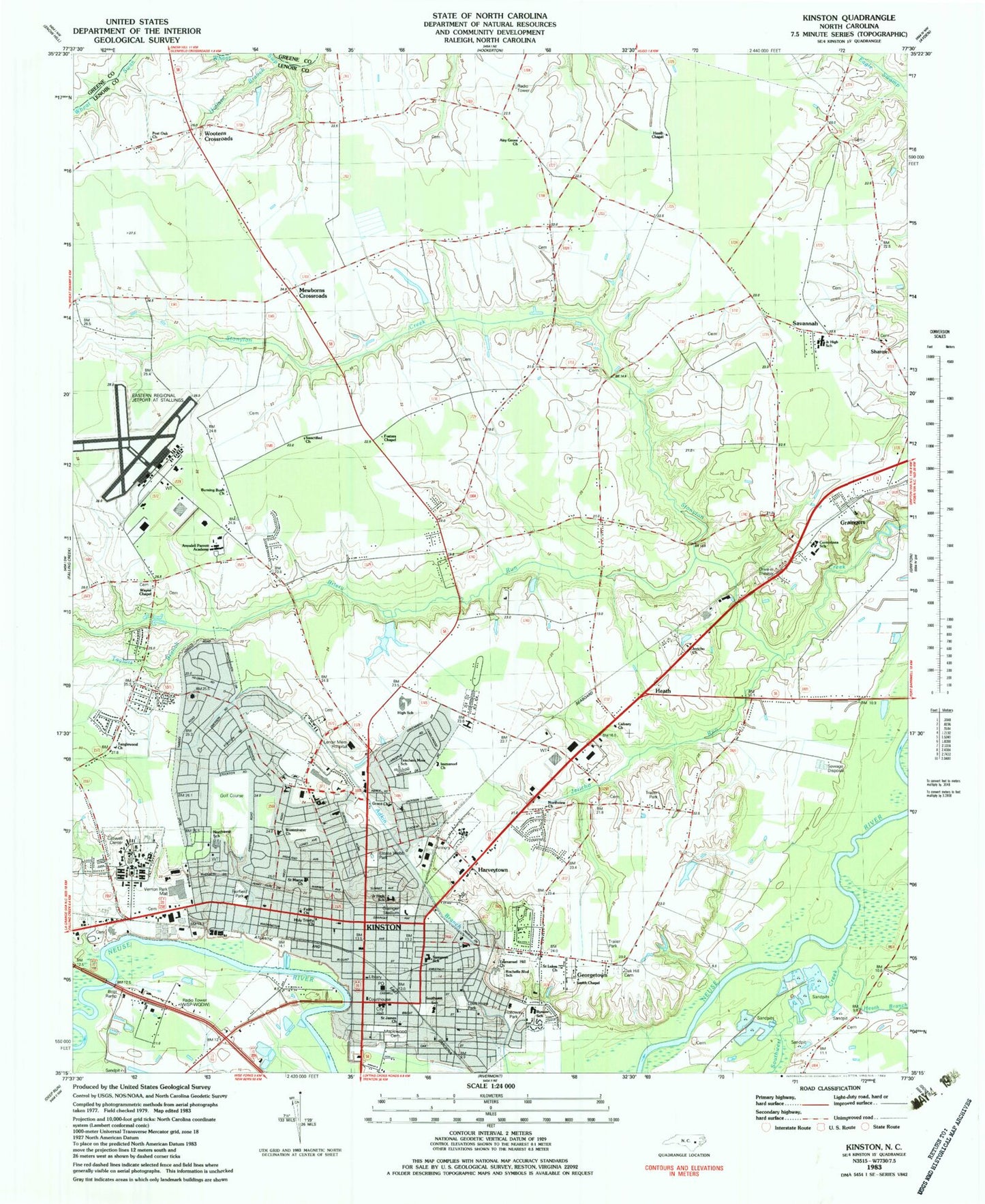
MyTopo
Classic USGS Kinston North Carolina 7.5'x7.5' Topo Map
Couldn't load pickup availability
Historical USGS topographic quad map of Kinston in the state of North Carolina. Map scale may vary for some years, but is generally around 1:24,000. Print size is approximately 24" x 27"
This quadrangle is in the following counties: Greene, Lenoir.
The map contains contour lines, roads, rivers, towns, and lakes. Printed on high-quality waterproof paper with UV fade-resistant inks, and shipped rolled.
Contains the following named places: Airy Grove Church, Airy Grove School, Arendell Parrot Academy, Bill Fay Memorial Park, Brentwood, Briery Run, Bright School, Britthaven of Kinston, Burning Bush Church, Bynum Park, Bynum School, Calvary Church, Carver Court Community Center, Caswell Developmental Center, Caswell Developmental Center Hospital, Caswell Number 1 Fire Station Museum, Caswell-Newse State Historic Site, Centennial Arms, City of Kinston, Club Pines, Clubview, Colonial Hights, Contentnea Elementary School, Country Club Estates, Eastover, Edgefield Forest, Emma Webb Park, Emmanuel Hill Church, Fairfield Park, Faith Church, First Baptist Church, Fosters Chapel, George Washington Carver, Georgetown, Grace Church, Grainger Stadium, Graingers, Graingers Census Designated Place, Greenmead, Grove Park, Hallam Branch, Happersville, Hardee Heights, Harmony Hall, Harveytown, Heath, Heath Branch, Heath Chapel, Herritage Plaza, Hines Junction, Holloway Park, Holy Trinity Church, Howard Hights, Hugo Volunteer Fire Department - Station 2, Immanuel Church, J H Sampson Elementary School, Jericho Church, Jericho Run, Jericho School, Kenwood Acres, Kinfield Village, Kingwood Forest, Kinston, Kinston City Hall, Kinston Clinic, Kinston Country Club and Golf Course, Kinston Department of Fire and Rescue - Station 1, Kinston Fire and Rescue Department Station 4, Kinston High School, Kinston Junior High School, Kinston Marine Corps Auxiliary Air Facility, Kinston Plaza Shopping Center, Kinston Police Department, Kinston Post Office, Kinston Regional Jetport at Stallings Field, Kinston Rehabilitation and Healthcare Center, Kinston Square, Lawarence Hights, Lenoir County Chamber of Commerce, Lenoir County Criminal Justice, Lenoir County Emergency Services, Lenoir County Sheriff's Office, Lenoir Memorial Hospital, Lenoir Pines, Lewis Elementary School, Liberty Hill Park, Lovit Hires Park, Maplewood Cemetery, Martin Freeman Community Center, McLewean Square, Mewborns Crossroads, Mitchell Community Center, North Carolina State Highway Patrol Troop A District 7, Northview, Northview Church, Northwest School, Oak Hill Cemetery, Oak Lawn, Oakdale School, Old Farm, Park View Shopping Center, Perry Park, Plaza Kinston Post Office, Post Oak Church, Rochelle Blvd School, Rolling Pines, Saint James Church, Saint Lukes Church, Saint Marys Church, Sanctified Church, Savannah, Savannah Junior High School, Sharon, Sharon Church, Sherwood Forest, Sleepy Fox Village Mobile Home Park, Smith Chapel, Southeast Park, Southeast School, Southwest Creek, Spring Arbor of Kinston, Tanglewood, Tanglewood Church, Tarheel Courts, Taylor Crossroads, Taylors Branch, Teachers Memorial School, Tower Heights, Township of Kinston, Township of Vance, Tyndall Park, Vernon Park Mall, Wallace School, Wayne Chapel, West haven, Westminster Church, Westwood, White School, WISP-AM (Kinston), Woods View, Wootens Crossroads, Worth School, WQDW-FM (Kinston)