MyTopo
Classic USGS Landersville Alabama 7.5'x7.5' Topo Map
Couldn't load pickup availability
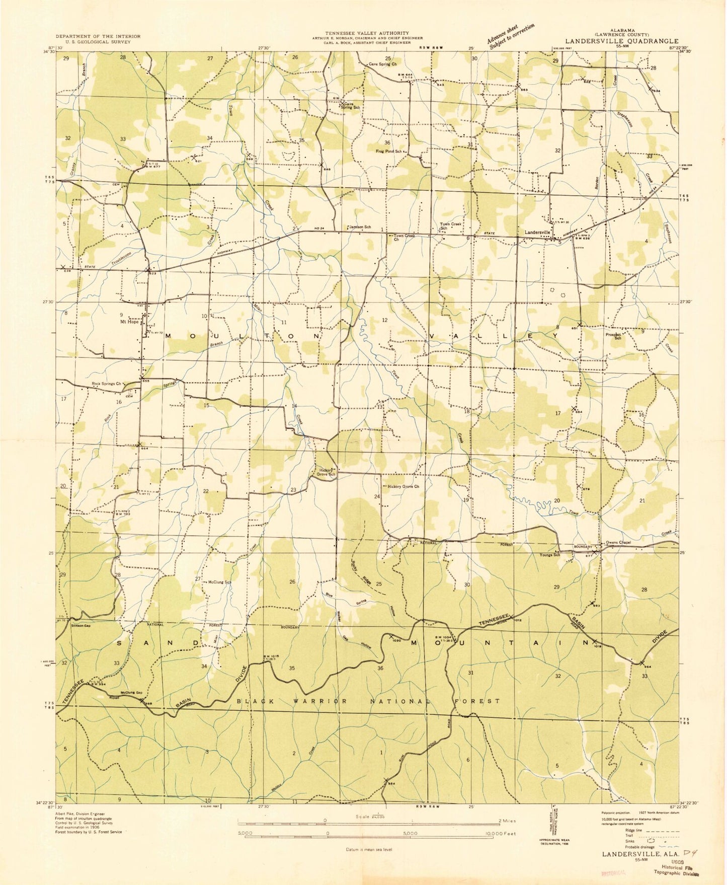
Historical USGS topographic quad map of Landersville in the state of Alabama. Typical map scale is 1:24,000, but may vary for certain years, if available. Print size: 24" x 27"
This quadrangle is in the following counties: Lawrence.
The map contains contour lines, roads, rivers, towns, and lakes. Printed on high-quality waterproof paper with UV fade-resistant inks, and shipped rolled.
Contains the following named places: Little Bear Creek Reservoir, Blue Spring Hollow, Cave Spring, Cave Springs Freewill Baptist Church, Cedar Ridge, Cold Spring Hollow, Dry Creek, Goat Bluff, Gum Pond Cemetery, Hickory Grove, Hickory Grove Church, Landersville, Mattox Creek, McClung Gap, Milam Creek, Morgan Hollow, Mount Hope, Needmore, Old Prospect Cemetery, Old Town Creek Church, Owen Chapel, Rock Spring, Rock Springs Branch, Rock Springs Church, Rock Springs Church, Rocky Branch, Rocky Ridge, Smith Cemetery, Stinson Branch, Stinson Gap, Stinson Spring, Town Creek Cemetery, Town Creek Number One Missionary Baptist Church, Troublesome Creek, Tucker Spring Hollow, Walker Gap, Walker Gap Hollow, Walker Mill Hollow, Wear Cemetery, Youngtown, Philpot Lake, Town Creek Watershed Number 22 Dam, Hardin Lake, Town Creek Watershed Number 14 Dam, Christian Church (historical), Gum Pond Church (historical), Mount Hope Church, Prospect Church (historical), State School (historical), Young Town School (historical), Landersville Elementary School (historical), Camp Spring (historical), Cave Spring School (historical), Frog Pond School (historical), Hickory Grove School (historical), Jamison School (historical), McClung School (historical), Prospect School (historical), Town Creek School (historical), Mount Hope Church of Christ, Mount Hope High School, Mount Hope Division, Landersville Cemetery, Landersville Church of Christ, Youngs School (historical), Elam's Landing, Mount Hope Volunteer Fire Department, Mount Hope Post Office, Little Bear Creek Reservoir, Blue Spring Hollow, Cave Spring, Cave Springs Freewill Baptist Church, Cedar Ridge, Cold Spring Hollow, Dry Creek, Goat Bluff, Gum Pond Cemetery, Hickory Grove, Hickory Grove Church, Landersville, Mattox Creek, McClung Gap, Milam Creek, Morgan Hollow, Mount Hope, Needmore, Old Prospect Cemetery, Old Town Creek Church, Owen Chapel, Rock Spring, Rock Springs Branch, Rock Springs Church, Rock Springs Church, Rocky Branch, Rocky Ridge, Smith Cemetery, Stinson Branch, Stinson Gap, Stinson Spring, Town Creek Cemetery, Town Creek Number One Missionary Baptist Church, Troublesome Creek, Tucker Spring Hollow, Walker Gap, Walker Gap Hollow, Walker Mill Hollow, Wear Cemetery, Youngtown, Philpot Lake, Town Creek Watershed Number 22 Dam, Hardin Lake, Town Creek Watershed Number 14 Dam, Christian Church (historical), Gum Pond Church (historical), Mount Hope Church, Prospect Church (historical), State School (historical), Young Town School (historical), Landersville Elementary School (historical), Camp Spring (historical), Cave Spring School (historical), Frog Pond School (historical), Hickory Grove School (historical), Jamison School (historical), McClung School (historical), Prospect School (historical), Town Creek School (historical), Mount Hope Church of Christ, Mount Hope High School, Mount Hope Division, Landersville Cemetery, Landersville Church of Christ, Youngs School (historical), Elam's Landing, Mount Hope Volunteer Fire Department, Mount Hope Post Office