MyTopo
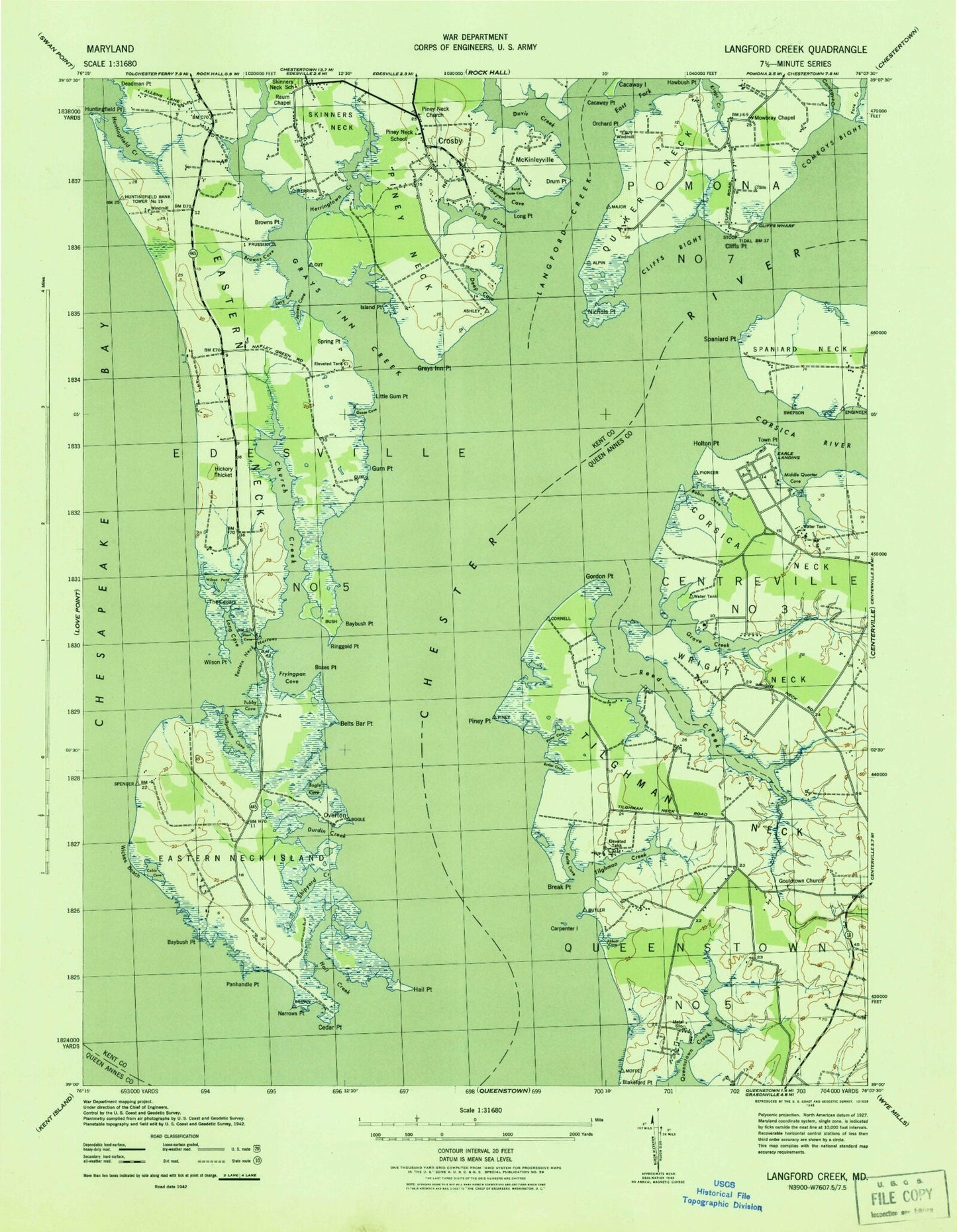
Classic USGS Langford Creek Maryland 7.5'x7.5' Topo Map
Couldn't load pickup availability
Historical USGS topographic quad map of Langford Creek in the state of Maryland. Map scale may vary for some years, but is generally around 1:24,000. Print size is approximately 24" x 27"
This quadrangle is in the following counties: Kent, Queen Anne's.
The map contains contour lines, roads, rivers, towns, and lakes. Printed on high-quality waterproof paper with UV fade-resistant inks, and shipped rolled.
Contains the following named places: Abbott Cove, Baker, Baybush Point, Belts Bar Point, Blakeford, Bogle Cove, Bogles Boat Ramp, Bogles Wharf, Boxes Point, Boxes Point Trail, Break Point, Browns Cove, Browns Point, Bulle Rock, Bulle Rock Farm, Burnt House Cove, Butler Cove, Cabin Cove, Cacaway Island, Cacaway Point, Calfpasture Cove, Carpenter Island, Cedar Point, Cherry Tree Point, Church Creek, Cliffs Bight, Cliffs City, Cliffs Point, Cliffs Wharf, Cockey Island, Comegys Bight, Comegys Creek, Conquest Beach, Corsica River, Crawford's Chance Farm, Crosby, Davis Creek, Deep Cove, Ditchers Cove, Drum Point, Duck Inn Trail, Durdin Creek, Earle Cove, Earle Landing, East Fork Langford Creek, Eastern Neck, Eastern Neck Island, Eastern Neck Narrows, Eastern Neck National Wildlife Refuge, Ellendale Campground, Emory Landing, Fore Creek, Fryingpan Cove, Goose Cove, Gordon Point, Gouldtown Cemetery, Gouldtown Church, Grays Inn Creek, Grays Inn Point, Grove Creek, Gum Point, Hail Creek, Hail Point, Harris Wharf, Herringtown Creek, Hickory Thicket, Hills Point, Holton Point, Huntingfield Creek, Huntingfield Point, Ingleside Recreation Area, Island Point, Jerrys Cove, Joiners Cove, Langford Creek, Langfords Bay, Lankford Bay Marina, Lawyers Cove, Learys Mill, Learys Wharf, Little Gum Point, Long Cove, Long Cove Marina, Long Point, Lucy Cove, Mallard Point, McKinleyville, Middle Quarter Cove, Mowbray Chapel, Narrows Point, New Yarmouth, Nichols Point, Orchard Point, Overton, Panhandle Point, Piney Cove, Piney Neck, Piney Neck Church, Piney Neck School, Piney Point, Pioneer Point Farms, Prussian Point, Quaker Neck, R J Campground, Raum Chapel, Recovery, Reed Creek, Ringgold Point, River Estates, Robin Cove, Rush Island, School Number 1, Shippen Cove, Shipyard Creek, Short Cove, Skinners Neck, Skinners Neck School, Skinners Point, Spaniard Point, Spaniards Landing, Spring Point, Stoney Point, Sycamore Point, The Cedars, Tilghman Creek, Tilghman Neck, Toms Point, Town Point, Tubby Cove, Upper Spaniards Point, West Fork Langford Creek, White Banks, Wickes Beach, Wickes Memorial Historical Marker, Wilson Point, Wilson Pond, Wright Neck, ZIP Code: 21661