MyTopo
Classic USGS Lansing North Michigan 7.5'x7.5' Topo Map
Couldn't load pickup availability
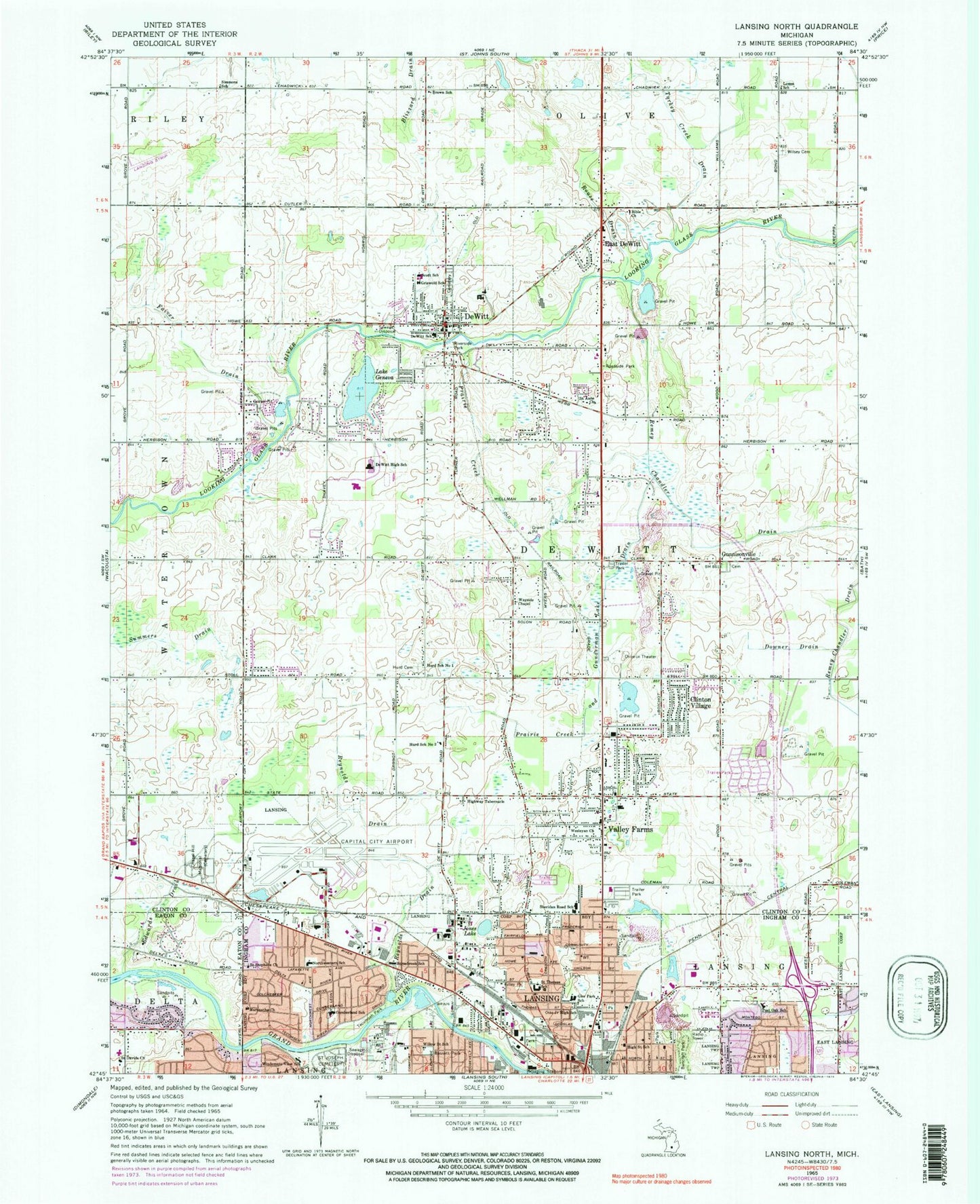
Historical USGS topographic quad map of Lansing North in the state of Michigan. Map scale may vary for some years, but is generally around 1:24,000. Print size is approximately 24" x 27"
This quadrangle is in the following counties: Clinton, Eaton, Ingham.
The map contains contour lines, roads, rivers, towns, and lakes. Printed on high-quality waterproof paper with UV fade-resistant inks, and shipped rolled.
Contains the following named places: Asbury United Methodist Church, Bancroft Park, Bassett Park, Bible Church, Brown School, Cadgewith Farms Mobile Home Park, Capital Region International Airport, Capital Region International Airport Fire Department, Capital Regional Airport Authority Police Department, Chapel Hill Memorial Gardens, Charter Township of DeWitt, Christ United Church, Church of God, City of DeWitt, Clinton Village, Cumberland Elementary School, Delta Medical Center, Delta Mills Schools Historical Marker, DeWitt, Dewitt Area Fire and Emergency Services Authority, DeWitt Cemetery, DeWitt Charter Township Fire Department Station 2, DeWitt Christian Church, DeWitt Family Golf Center, DeWitt Family Practice, DeWitt High School, DeWitt Junior High School, Dewitt Police Department, DeWitt Post Office, DeWitt Public Library, Dewitt Township Fire Department Station 1, DeWitt Township Police Department, DeWitt United Brethren in Christ Church, Dietrich Park, Dodge Park, Downer Drain, East DeWitt, Eastwood Towne Center, Edwards Drain, Elmwood Elementary School, Faith Church, Faiver Drain, Filley Park, First Baptist Church, Fuerstenau Elementary School, Gier Park, Gier Park School, Griswold School, Gunnisonville, Gunnisonville Cemetery, Gunnisonville Elementary School, Gunnisonville Historical Marker, Gunnisonville Post Office, Gunnisonville United Methodist Church, Gunnisonville United Methodist Church Historical Marker, Herbison Woods School, Heritage Baptist Church, High Street School, Highway Tabernacle, Hope Lutheran Church, Horsebrook Park, Horsebrook School, Hurd Cemetery, Hurd School Number 1, Hurd School Number 2, Immanuel Community Reformed Church, Ingham Community Medical Center, Jehovah's Witnesses, Jones Lake, Jones Lake Park, Kimberly Park, King Arthur Mobile Home Park, Kristana Mobile Home Park, Lake Geneva, Lansing Fire and Rescue Station 2, Lemm School, Lighthouse Chapel, Lively Faith Temple, Maranatha Church, Marantha Assembly of God Church, Mount Hope Church-DeWitt, Mount Zion Church, Northpoint Community Church, Northwestern Elementary School, Orla McGuire Park, Otto Middle School, Padgett Park, Paulsen Park, Philip Orin Parmelee Historical Marker, Porter Park, Post Oak Elementary School, Prairie Creek, Prairie Creek and Gunderman Lake Drain, Prairie Creek Golf Course, Reasoner Park, Redeemer United Methodist Church, Reynolds Drain, Riverside Park, Rotunda Mobile Home Park, Rouse Drain, Royal Scot Golf Course, Saint Anne Church, Saint Davids Church, Saint Joseph Cemetery, Saint Jude Catholic Church, Saint Stephens Church, Saint Therese Church, Saint Therese School, Sanctuary Gate Church, Schavey Road Elementary School, Scott School, Seventh Park, Sheridan Road School, Simmons School, Spanish Church of God, Summers Drain, Tecumseh Park, Turkey Creek Drain, Turner-Dodge House Historical Marker, United Methodist Church, Valley Estates Mobile Home Park, Valley Farms, Walker Memorial Bible Church, Wayside Chapel, Wesleyan Church, Williams Chapel Church of God, Willow Street School, Wilsey Cemetery, Wilson Park, Windemere View School, Zischke Airport, ZIP Codes: 48820, 48906