MyTopo
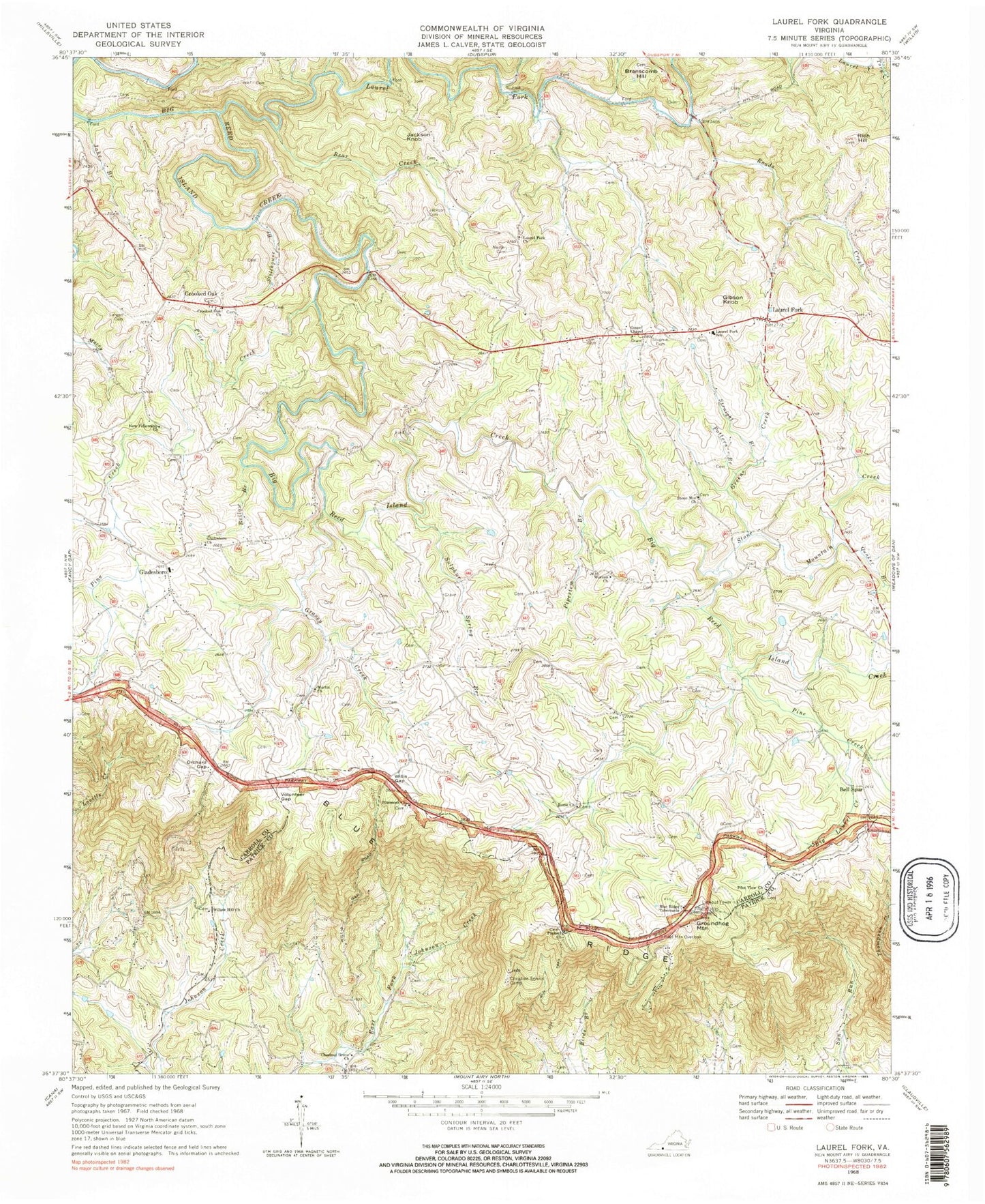
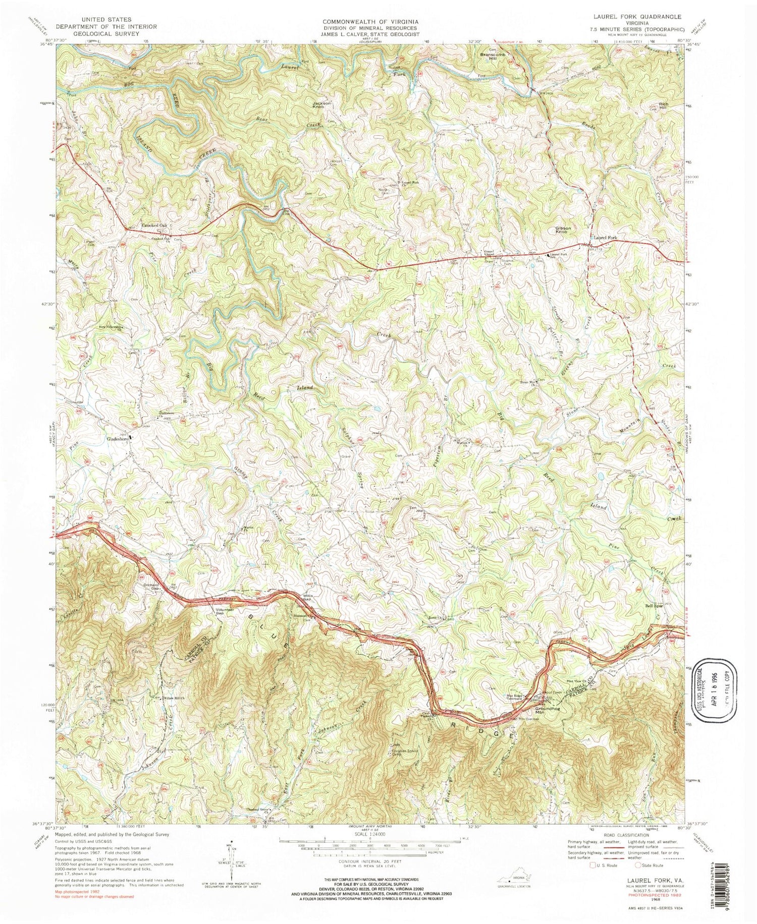
Classic USGS Laurel Fork Virginia 7.5'x7.5' Topo Map
Couldn't load pickup availability
Historical USGS topographic quad map of Laurel Fork in the state of Virginia. Map scale may vary for some years, but is generally around 1:24,000. Print size is approximately 24" x 27"
This quadrangle is in the following counties: Carroll, Patrick.
The map contains contour lines, roads, rivers, towns, and lakes. Printed on high-quality waterproof paper with UV fade-resistant inks, and shipped rolled.
Contains the following named places: Barnes Cemetery, Bear Creek, Bell Spur, Bellow Branch, Big Laurel Creek, Blue Ridge Tabernacle, Bluemont Cemetery, Bluemont Church, Bolt Cemetery, Bowman Cemetery, Bowman-Fariss-Martin Cemetery, Branscomb Hill, Branscome Cemetery, Chestnut Grove Church, Christian Service Camp, Combs Cemetery, Crooked Oak, Crooked Oak Cemetery, Crooked Oak Church, Cruise Cemetery, Daniel Dickens Cemetery, Daniel Stanley Cemetery, Eli Sowers Cemetery, Flurnoy Cloud Cemetery, Gibson Knob, Gladesboro, Gladesboro Cemetery, Gladesboro Church, Gladesboro Elementary School, Goad Cemetery, Gospel Chapel, Grassy Creek, Greens Creek, Groundhog Hill Cemetery, Groundhog Mountain, Henry F Vass Cemetery, Hurst Cemetery, Jackson Cemetery, Jackson Knob, Jake Branch, James Cloud Cemetery, James F Goad Cemetery, John Cassell Cemetery, John Finney Cemetery, John Largen Cemetery, Jonah Marshall Cemetery, Largen Cemetery, Laurel Fork, Laurel Fork Cemetery, Laurel Fork Church, Laurel Fork District, Laurel Fork Elementary School, Laurel Fork Fire Department, Laurel Fork Post Office, Laurel Fork Rescue Squad, Light's Farm, Love Cemetery, Marshall Cemetery, Marshall-Mabry Cemetery, Martin Cemetery, Martin Church, McGrady Cemetery, McGrady-Thomas Cemetery, McMillian Cemetery, Moles Cemetery, Nester, Nester Cemetery, New Fellowship Church, Olde Mill Golf Club Dam, Orchard Gap, Pendleton Cemetery, Pilot Mountain Overlook, Pilot View Cemetery, Pilot View Church, Pilot View School, Pine Creek, Pipestem Branch, Potters Branch, Puckett Cemetery, Puckett Church, Puckett Memorial Cemetery, Quaker Branch, Quesinberry Cemetery, Rich Hill, Roads Creek, Rome Cemetery, Rome Church, Run Trail, Semones Cemetery, Shadrick Worrell Cemetery, Stillhouse Branch, Stone Mountain Cemetery, Stone Mountain Church, Stone Mountain Creek, Straight Branch, Strock Chapel Cemetery, Stuphin Cemetery, Sulphur Spring Branch, Tobler Cemetery, Turner-Duncan Cemetery, Victor Webb Cemetery, Volunteer Gap, Webb Cemetery, Weddle Cemetery, Wemmering Airport, Willard Cemetery, William Jackson Cemetery, Willis Gap, Willow Hill Cemetery, Willow Hill Church, Wilson Cemetery, Worrell Church, Worrell Memorial Cemetery, ZIP Code: 24352