MyTopo
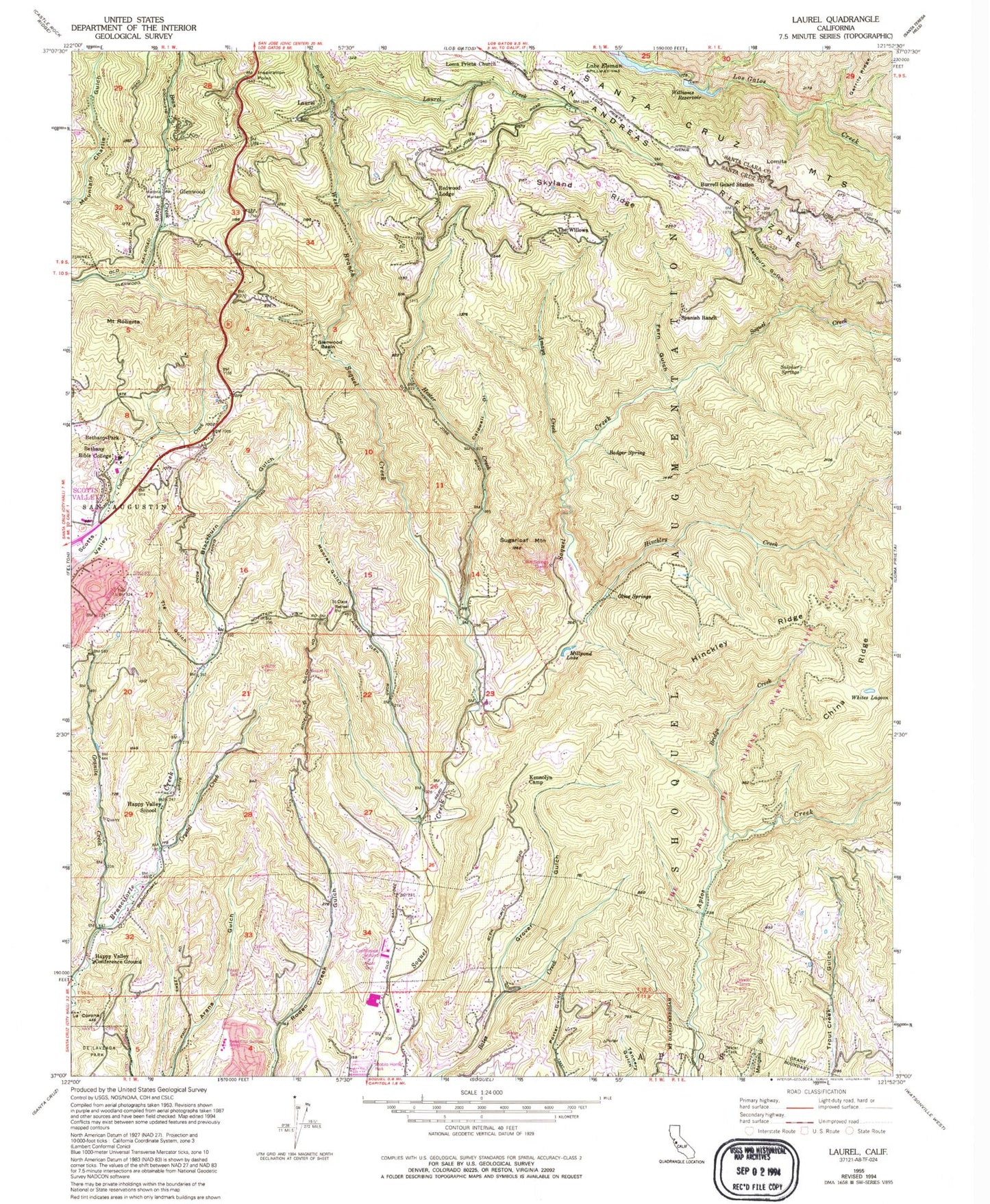
Classic USGS Laurel California 7.5'x7.5' Topo Map
Couldn't load pickup availability
Historical USGS topographic quad map of Laurel in the state of California. Typical map scale is 1:24,000, but may vary for certain years, if available. Print size: 24" x 27"
This quadrangle is in the following counties: Santa Clara, Santa Cruz.
The map contains contour lines, roads, rivers, towns, and lakes. Printed on high-quality waterproof paper with UV fade-resistant inks, and shipped rolled.
Contains the following named places: Amaya Creek, Ashbury Gulch, Badger Spring, Bethany University, Blackburn Gulch, Bridge Creek, Burns Creek, Burrell Guard Station, Burrell School, China Ridge, Fern Gulch, Garrity Ridge, Glenwood, Glenwood Basin, Glenwood School (historical), Granite Creek, Grover Gulch, Happy Valley Conference Ground, Happy Valley Elementary School, Hester Creek, Hester Creek Church, Highland School (historical), Hinckley Creek, Hinckley Ridge, Inspiration Point, Kennolyn Camp, La Corona, Laurel, Laurel Creek, Loma Prieta Church, Millpond Lake, Moores Gulch, Mountain Elementary School, Olive Spring, Olives Spring Quarry, Saint Clare Retreat, Saint Marys Girls Camp, Shoquel Augmentation, Skyland Ridge, Spanish Ranch, Sugarloaf Mountain, Sulphur Springs, Tie Gulch, Whites Lagoon, Williams Reservoir, Crystal Creek, Caldwell Gulch, Bethany Park, Redwood Lodge, Mount Roberta, The Willows, Williams 622-004 Dam, KFER-FM (Santa Cruz), Brush Lagoon (historical), Clems (historical), Fontenay Villa, Halls Bridge, Hazelbrook School (historical), Hester Creek School (historical), Mountain View Ranch (historical), Olive Springs (historical), Tunnel Number 2, Vine Hill School (historical), Magnetic Spring (historical), Chaminade School (historical), Fidel Ranch, Aptos Creek Trail, Bethany Park, Big Slide Trail, Big Stump Trail, Bottom of the Incline, Bridge Creek Historic Site, Camp Comfort (historical), Charles Derby Small Bore Range, Georges Picnic Area, Happy Valley Church of Jesus Christ of Latter Day Saints, Happy Valley School District Office, Highland (historical), Hoffman Historic Site, Loma Prieta Mill (historical), Maple Falls, Mary Easton Picnic Area, Mill Pond Trail, Porter Family Picnic Area, Porter House (historical), Porter Trail, Sand Point, Sand Point Overlook, Santas Village Shopping Center, Sporup Sanitarium, Top of the Incline, Trout Gulch Trail, Vine Hill Elementary School, West Ridge Trail, West Ridge Trail Camp, Lone Tree Prairie, Santa Cruz Gardens Elementary School, Mountain Bible Christian School, Summit Road Division, Soquel Fire Department, Branciforte Fire Protection District, West Branch Soquel Creek