MyTopo
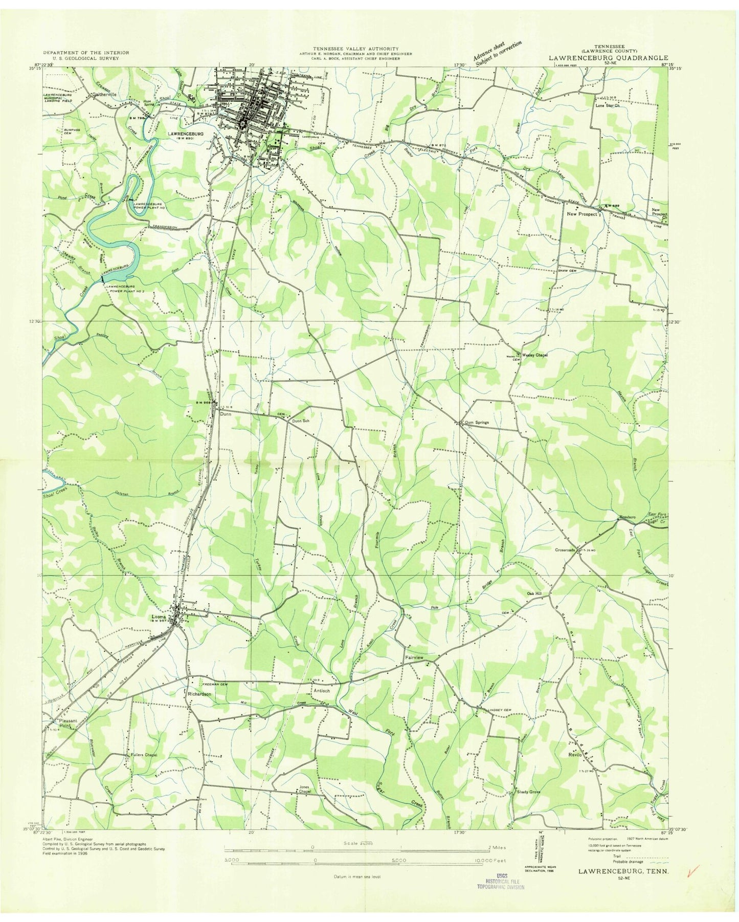
Classic USGS Lawrenceburg Tennessee 7.5'x7.5' Topo Map
Couldn't load pickup availability
Historical USGS topographic quad map of Lawrenceburg in the state of Tennessee. Map scale may vary for some years, but is generally around 1:24,000. Print size is approximately 24" x 27"
This quadrangle is in the following counties: Lawrence.
The map contains contour lines, roads, rivers, towns, and lakes. Printed on high-quality waterproof paper with UV fade-resistant inks, and shipped rolled.
Contains the following named places: Antioch, Antioch Church, Bailey Hollow Branch, Beeler Fork, Brock Hollow, Brock Spring, Brown Lake, Bumpas Cemetery, Callahan Branch, Calvary Baptist Church, Cherry Hill Spring, City of Lawrenceburg, Coleman Memorial United Methodist Church, Commissioner District 16, Commissioner District 18, Commissioner District 4, Commissioner District 7, Commissioner District 8, Coon Creek, Crossroads, Crossroads Cemetery, Crossroads Fire Department, Crossroads Freewill Baptist Church, Crowson Creek, Dotson Cemetery, Downtown Church of Christ, Dry Land Creek, Dunn, Dunn Cemetery, Dunn Church, Dunn School, E O Coffman Middle School, East End Methodist Church, Fairview, First Assembly of God Church, First Baptist Church, First Presbyterian Church, First Street Church of Christ, First United Methodist Church, Fourmile Branch, Freemon Cemetery, Fuller Chapel Cemetery, Fullers Chapel, Fullers Chapel School, Gaitherville, Garner Mill, Giles Branch, Glen Spring, Grace Church of the Nazarene, Green Cemetery, Gum Springs, Gum Springs Cemetery, Gum Springs Church, Gum Springs School, Halls Stand, Hardy Branch, Haynie Branch, Hickman Cemetery, Hickory Heights, Highland Park Baptist Church, Hood Lake, Hood Springs, Hope Spring, Horseshoe Bend, Immanuel Baptist Church, Ingram-Sowell Elementary School, Jones Chapel, Kingdom Hall of Jehovahs Witnesses, Lawrence County Ambulance Service, Lawrence County Courthouse, Lawrence County Hospital, Lawrence County Public Library, Lawrence County Sheriff's Department, Lawrenceburg, Lawrenceburg Church of the Nazarene, Lawrenceburg City Cemetery, Lawrenceburg City Hall, Lawrenceburg Cumberland Presbyterian Church, Lawrenceburg Division, Lawrenceburg Fire Department Station 1, Lawrenceburg Golf and Country Club, Lawrenceburg Number 1 Hydroelectric Station, Lawrenceburg Police Department, Lawrenceburg Post Office, Lawrenceburg Power Plant, Lawrenceburg School, Lawrenceburg United Pentecostal Church, Lawrenceburg-Lawrence County Airport, Leoma, Leoma Baptist Church, Leoma Cemetery, Leoma Census Designated Place, Leoma Church of Christ, Leoma Division, Leoma Elementary School, Leoma Fire and Rescue, Leoma Methodist Church, Leoma Post Office, Lindsey Grove Cemetery, Lindsey Grove Church, Little Shoal Creek, Lone Star Church, Love Branch, May Cemetery, McLean Cemetery, Mill Creek, Mimosa Cemetery, Moore Spring, Mount Olive Cemetery, New Prospect, New Prospect Church, New Prospect Fire Department, New Shoal Creek Dam, New Shoal Creek Reservoir, Oak Hill, Oak Hill Cemetery, Oak Hill Church, Old Shoal Creek Dam, Original Church of God, Pleasant Point, Pleasant Point Methodist Episcopal Church, Pleasant Point Nazarene Church, Pole Bridge Branch, Pond Creek, Prosser Creek, Pulaski Street Church of Christ, Raven Bluff, Redding Branch, Revilo, Revilo School, Richardson, Rosemont School, Rossboro, Royal Heights Baptist Church, Sacred Heart Catholic Church, Sacred Heart Parochial School, Saint Johns United Methodist Church, Shady Grove, Shaw Cemetery, Shawley Branch, Shay Branch, Sherrell Poultry Farms, Southern Tennessee Regional Health System Lawrenceburg, Springer Road Church of Christ, Steadman Ridge, Third Street Church of God, Trinity Baptist Church, Tripp Cemetery, Tripp Town Branch, Turkey Creek, WCMG-AM (Lawrenceburg), Wesley Chapel, Wesley Chapel Cemetery, West Gaines Street Church of Christ, West Highland Elementary School, Whiteoak Hollow, Wildcat Ridge, ZIP Code: 38468