MyTopo
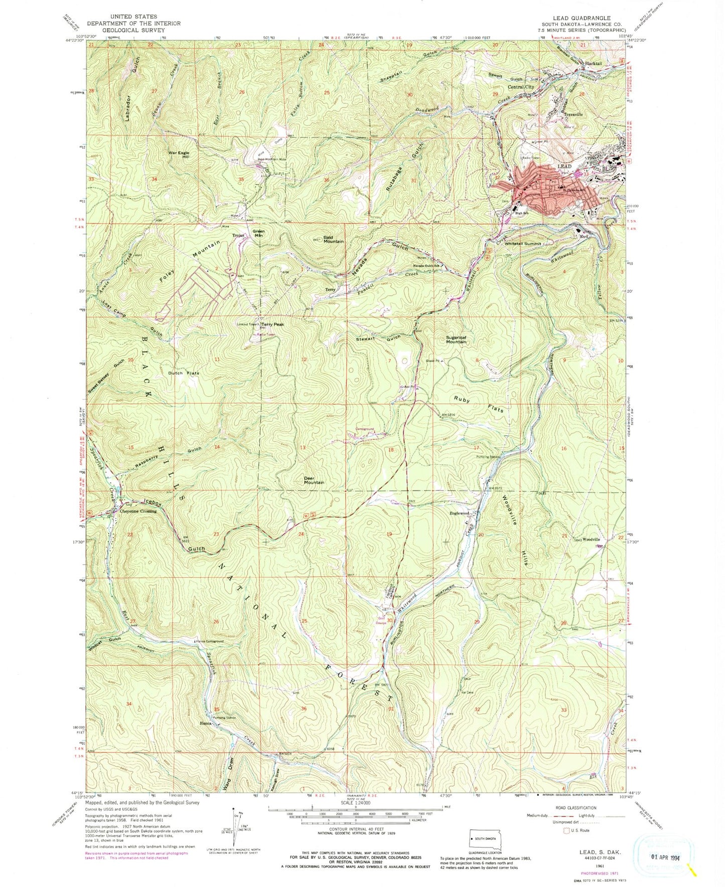
Classic USGS Lead South Dakota 7.5'x7.5' Topo Map
Couldn't load pickup availability
Historical USGS topographic quad map of Lead in the state of South Dakota. Typical map scale is 1:24,000, but may vary for certain years, if available. Print size: 24" x 27"
This quadrangle is in the following counties: Lawrence.
The map contains contour lines, roads, rivers, towns, and lakes. Printed on high-quality waterproof paper with UV fade-resistant inks, and shipped rolled.
Contains the following named places: Bald Mountain, Bald Mountain Mine, Blacktail Gulch, Bobtail Gulch, Central City, Deer Mountain, Dutch Flats, East Branch Cleopatra Creek, East Spearfish Creek, Englewood, Mountain Lawn Cemetery, Fantail Creek, Foley Mountain, Green Mountain, Hanna, Hanna Campground, Keough Draw, Lost Camp Gulch, Nevada Gulch School, Raspberry Gulch, Ruby Flats, Rutabaga Gulch, Saint Patricks School, Sawpit Gulch, Stewart Gulch, Sugarloaf Mountain, Terraville, Terry, War Eagle Hill, Ward Draw, Whitetail Creek, Whitetail Summit, Wildcat Gulch, Woodville Hills, Yellow Creek, KSQY-FM (Deadwood), Kirk, Reno Creek, Nevada Gulch, Woodville Lake, Lead Country Club, Gentle Annie Mine (historical), Deadwood Terra Mine, Minerva Mine, Jupiter Mine (historical), Esmeralda Mine (historical), Pinney Mine (historical), Harrison Mine, Etta Mine (historical), Union Mine (historical), Ruby Belle Mine (historical), Golden Reward Mine (historical), Glover Mine (historical), Apex Mine (historical), Portland Mine, Reliance Mine, Juno Mine (historical), Crown Hill Mine (historical), Upper Welcome Mine (historical), Harmony Mine, Daisy Mine (historical), Great Mogul Mine, Tornado Mine, Dividened Mine (historical), Little Tornado Mine (historical), Ben Hur Mine (historical), Baltimore Mine (historical), Snowstorm Mine (historical), Alameda Mine (historical), Sundance Mine, Fannie Mine (historical), Alpha-Platus Mine (historical), Clinton Mine (historical), Big Bonanza Mine (historical), Retriever Mine (historical), Gladiator Mine (historical), Pennsylvania Mine, Old Ironsides Mine (historical), Terry Station, Summit (historical), Portland Junction (historical), Horseshoe Grove (historical), Fantail Junction (historical), Flatiron I (historical), Carthage (historical), Cartesville (historical), Yates (historical), Welcome (historical), Astoria (historical), Baltimore (historical), Bald Mountain (historical), Aztec (historical), Sawmill Gulch, Gayville, American Eagle Mine, Dakota Mine, Two Johns Mine, Buxton Mine, Boscoble and Double Standard Mine, Dark Horse and General Grant Mine, Isadorah and Billie Mine, Ross Hannibal Mine, Little Blue Mine, Wusp Number 2 Mine, Hawkeye-Pluma Mine, Hidden Treasure Mine, Bismark Mine, Durango Mine, Monitor Mine, Golden Reward Mine, Folger Mine, Gunnison and Vulcan Mine, Blacktail, Cheyenne Crossing, Lead, Terry Peak, Trojan, Woodville, Annie Creek (historical), Icebox Gulch, Lawrence County, Greenmont Post Office (historical), City of Central City, City of Lead, West Lead Cemetery, Lead Fire Department, Lead Post Office, Phoebe Apperson Hearst Library, Lead City Hall, Black Hills Mining Museum, Lead-Deadwood High School, Lead-Deadwood Middle School, Lead City Police Department, South Lead Cemetery, Terry Cemetery, Holy Cross Cemetery