
MyTopo
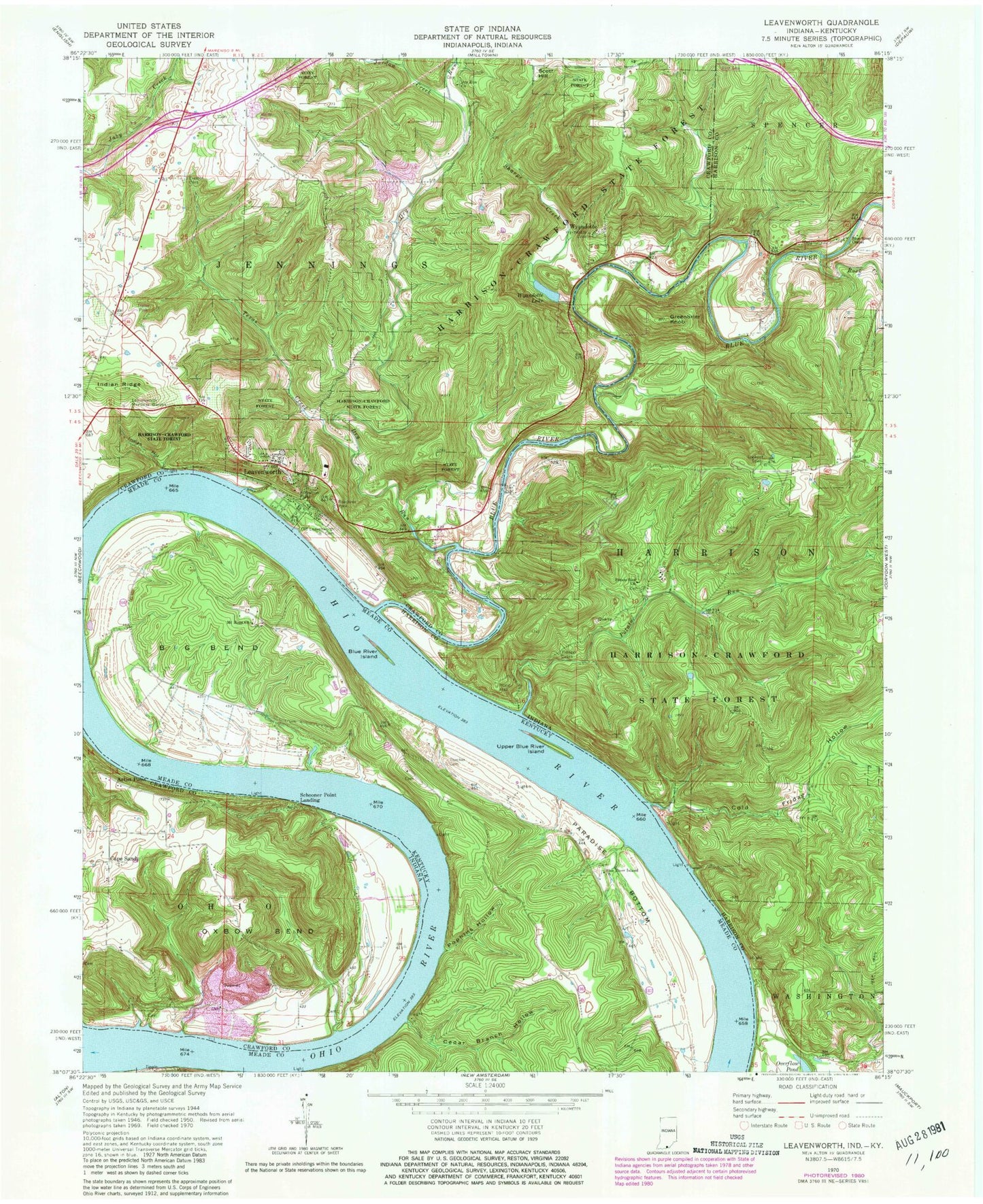
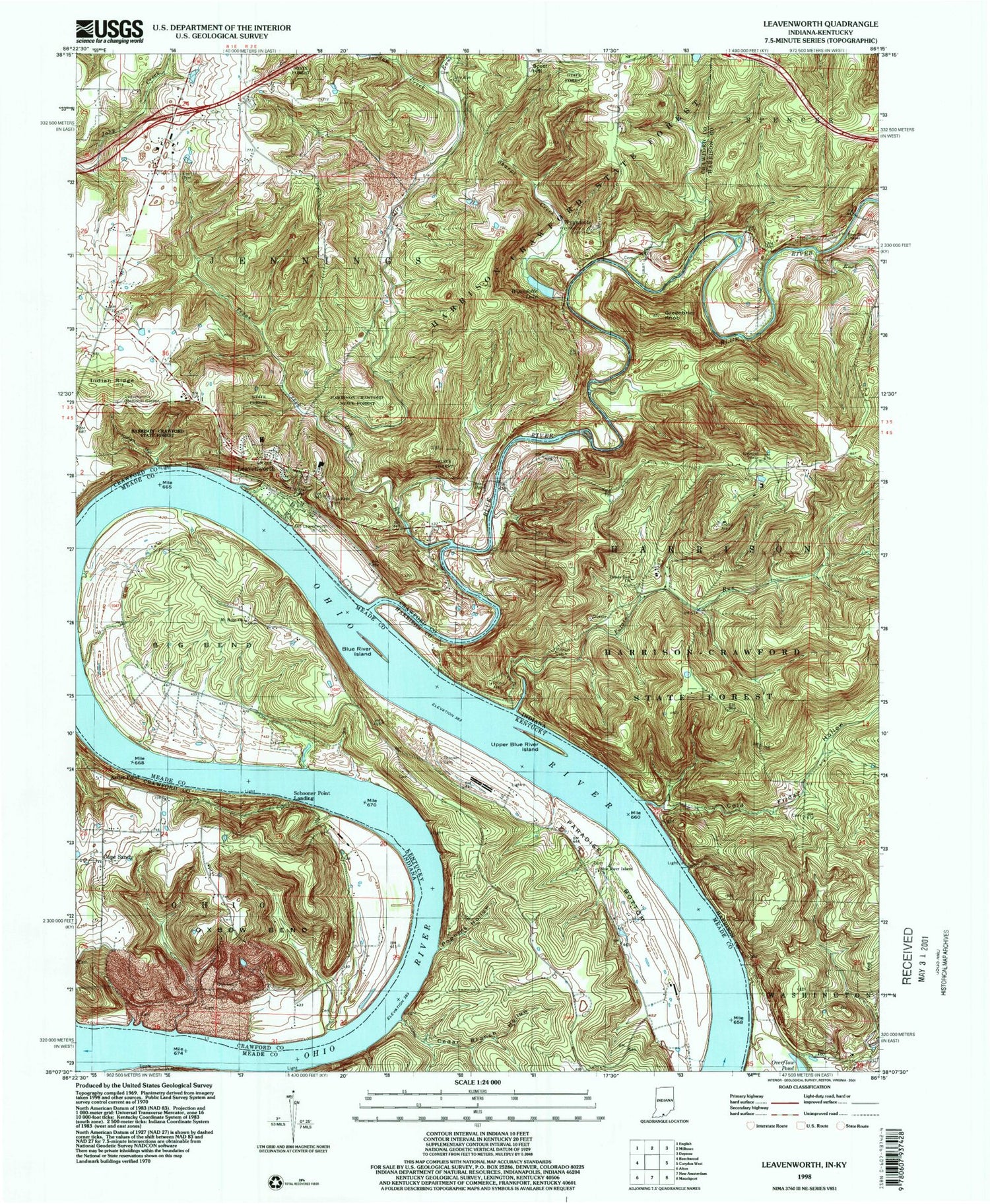
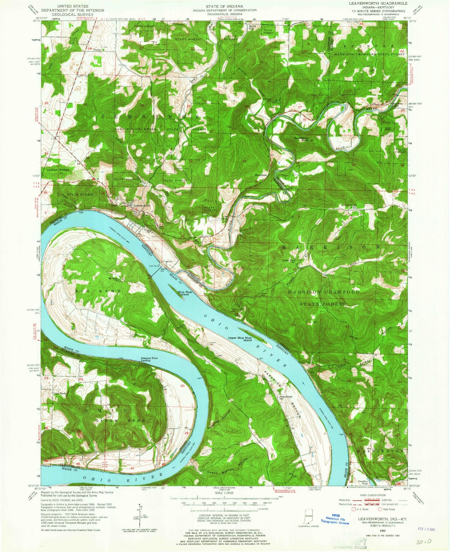
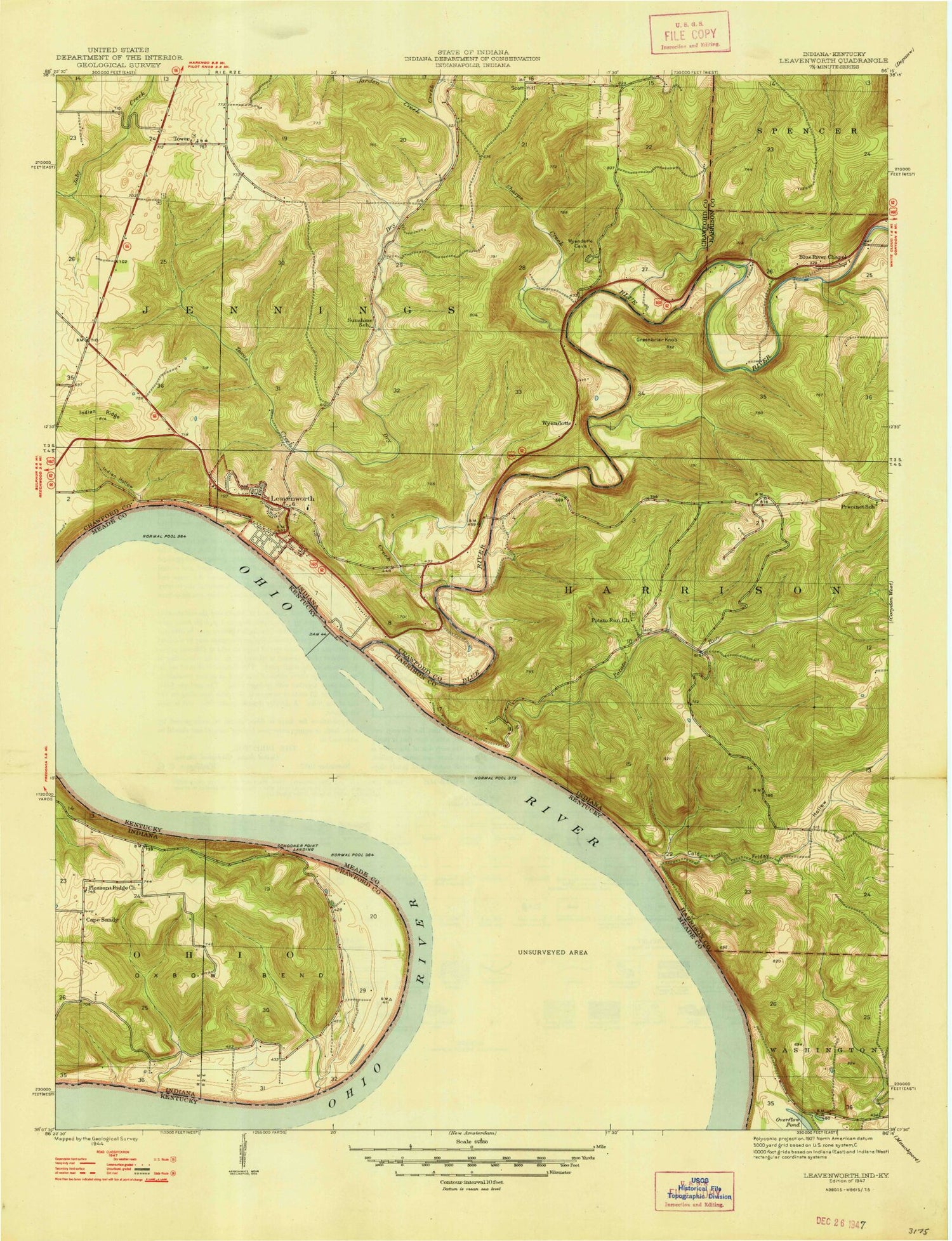
Classic USGS Leavenworth Indiana 7.5'x7.5' Topo Map
Couldn't load pickup availability
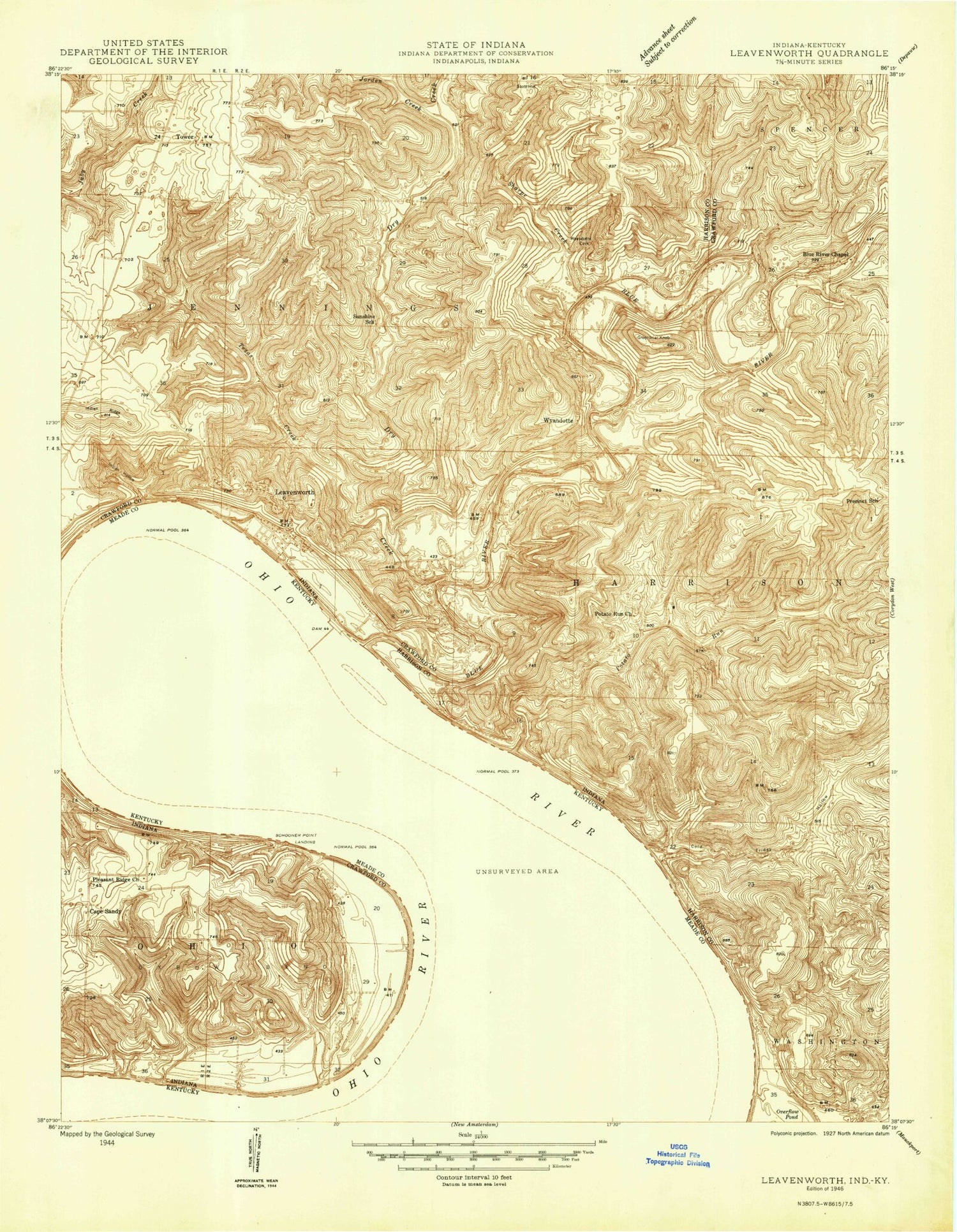
Historical USGS topographic quad map of Leavenworth in the states of Indiana, Kentucky. Typical map scale is 1:24,000, but may vary for certain years, if available. Print size: 24" x 27"
This quadrangle is in the following counties: Crawford, Harrison, Meade.
The map contains contour lines, roads, rivers, towns, and lakes. Printed on high-quality waterproof paper with UV fade-resistant inks, and shipped rolled.
Contains the following named places: Artist Point, Blue River Chapel, Brewer Cemetery, Cape Sandy, Cold Friday Hollow, Dry Run, Dry Run Church, Everdon and Old Tower Cemetery, Greenbrier Knob, Highland Creek, Indian Hollow, Indian Ridge, Jordan Creek, Leavenworth, Leavenworth Memorial Gardens, Old Leavenworth Cemetery, Oxbow Bend, Potato Run, Potato Run Church, Rock Creek, Scott Hill, Sharpe Creek, Texas Creek, Wyandotte, Wyandotte Lake, Leavenworth School, Wyandotte Woods, Wyandotte Cave, Wyandotte Lake Dam, Schooler Point Landing, Blue River, Harrison-Crawford State Forest, Township of Jennings, Pioneer Cabin, Town of Leavenworth, Leavenworth Volunteer Fire Department, Cape Sandy Quarry Number 1, Cape Sandy Quarry Number 2, Paris Landing, Leavenworth Post Office, Tower Cemetery, Scott Cemetery, Rothrock Cemetery, Borden Cemetery, Cedar Hill Cemetery, Big Bend, Blue River Island, Cedar Branch Hollow, Mount Hope Church, Paradise Bottom, Pophins Hollow, Thacker Cemetery, Upper Blue River Island, Blue River Island, Peckenpaugh (historical), Round Bottom, Artist Point, Blue River Chapel, Brewer Cemetery, Cape Sandy, Cold Friday Hollow, Dry Run, Dry Run Church, Everdon and Old Tower Cemetery, Greenbrier Knob, Highland Creek, Indian Hollow, Indian Ridge, Jordan Creek, Leavenworth, Leavenworth Memorial Gardens, Old Leavenworth Cemetery, Oxbow Bend, Potato Run, Potato Run Church, Rock Creek, Scott Hill, Sharpe Creek, Texas Creek, Wyandotte, Wyandotte Lake, Leavenworth School, Wyandotte Woods, Wyandotte Cave, Wyandotte Lake Dam, Schooler Point Landing, Blue River, Harrison-Crawford State Forest, Township of Jennings, Pioneer Cabin, Town of Leavenworth, Leavenworth Volunteer Fire Department, Cape Sandy Quarry Number 1, Cape Sandy Quarry Number 2, Paris Landing, Leavenworth Post Office, Tower Cemetery, Scott Cemetery, Rothrock Cemetery, Borden Cemetery, Cedar Hill Cemetery, Big Bend, Blue River Island, Cedar Branch Hollow, Mount Hope Church, Paradise Bottom, Pophins Hollow, Thacker Cemetery, Upper Blue River Island, Blue River Island, Peckenpaugh (historical), Round Bottom, Artist Point, Blue River Chapel, Brewer Cemetery, Cape Sandy, Cold Friday Hollow, Dry Run, Dry Run Church, Everdon and Old Tower Cemetery, Greenbrier Knob, Highland Creek, Indian Hollow, Indian Ridge, Jordan Creek, Leavenworth, Leavenworth Memorial Gardens, Old Leavenworth Cemetery, Oxbow Bend, Potato Run, Potato Run Church, Rock Creek, Scott Hill, Sharpe Creek, Texas Creek, Wyandotte, Wyandotte Lake, Leavenworth School, Wyandotte Woods, Wyandotte Cave, Wyandotte Lake Dam, Schooler Point Landing, Blue River, Harrison-Crawford State Forest, Township of Jennings, Pioneer Cabin, Town of Leavenworth, Leavenworth Volunteer Fire Department, Cape Sandy Quarry Number 1, Cape Sandy Quarry Number 2, Paris Landing, Leavenworth Post Office, Tower Cemetery, Scott Cemetery, Rothrock Cemetery, Borden Cemetery, Cedar Hill Cemetery, Big Bend, Blue River Island, Cedar Branch Hollow, Mount Hope Church, Paradise Bottom, Pophins Hollow, Thacker Cemetery, Upper Blue River Island, Blue River Island, Peckenpaugh (historical), Round Bottom, Artist Point, Blue River Chapel, Brewer Cemetery, Cape Sandy, Cold Friday Hollow, Dry Run, Dry Run Church, Everdon and Old Tower Cemetery, Greenbrier Knob, Highland Creek, Indian Hollow, Indian Ridge, Jordan Creek, Leavenworth, Leavenworth Memorial Gardens, Old Leavenworth Cemetery, Oxbow Bend, Potato Run, Potato Run Church, Rock Creek, Scott Hill, Sharpe Creek, Texas Creek, Wyandotte, Wyandotte Lake, Leavenworth School, Wyandotte Woods, Wyandotte Cave, Wyandotte Lake Dam, Schooler Point Landing, Blue River, Harrison-Crawford State Forest, Township of Jennings, Pioneer Cabin, Town of Leavenworth, Leavenworth Volunteer Fire Department, Cape Sandy Quarry Number 1, Cape Sandy Quarry Number 2, Paris Landing, Leavenworth Post Office, Tower Cemetery, Scott Cemetery, Rothrock Cemetery, Borden Cemetery, Cedar Hill Cemetery, Big Bend, Blue River Island, Cedar Branch Hollow, Mount Hope Church, Paradise Bottom, Pophins Hollow, Thacker Cemetery, Upper Blue River Island, Blue River Island, Peckenpaugh (historical), Round Bottom