MyTopo
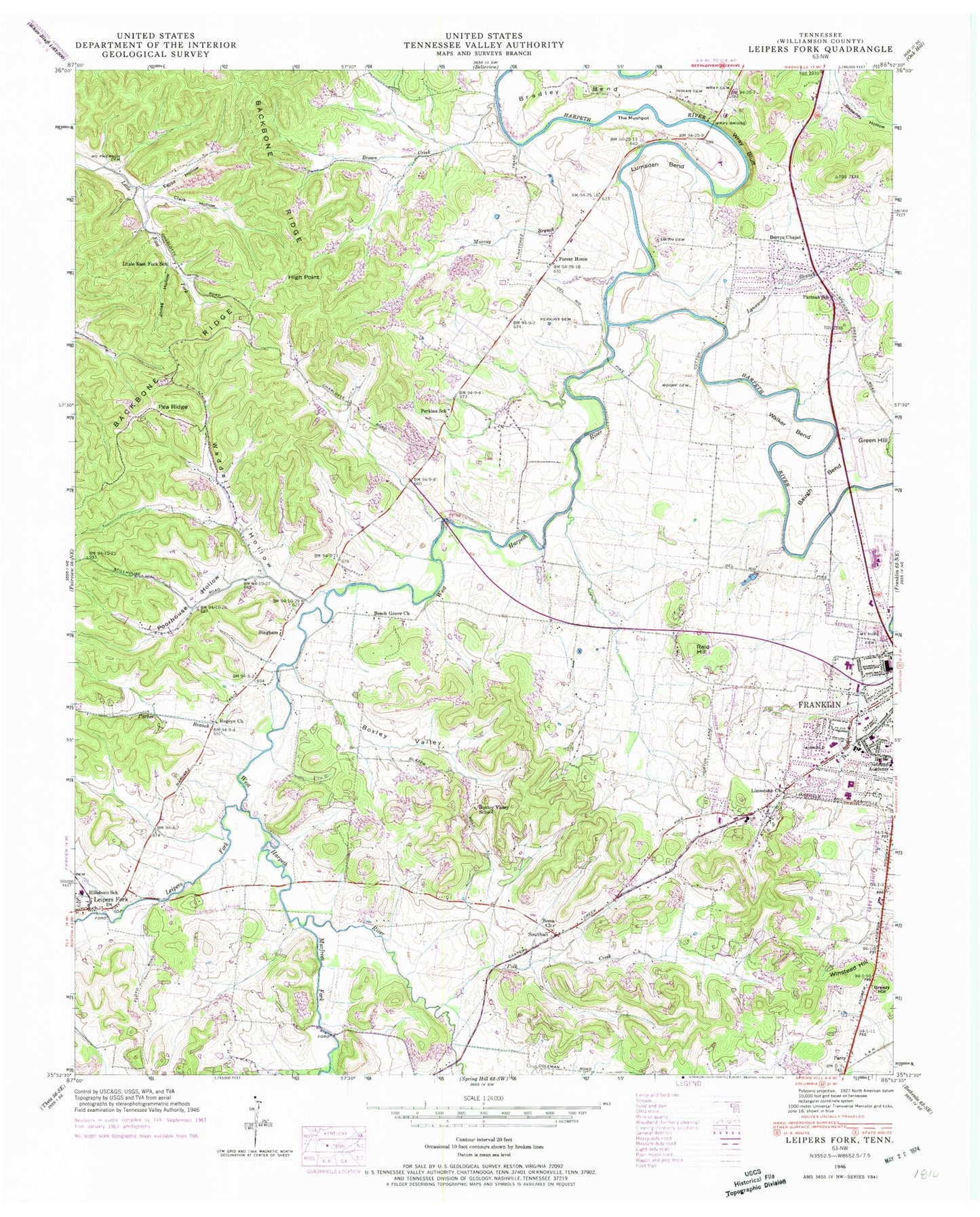
Classic USGS Leipers Fork Tennessee 7.5'x7.5' Topo Map
Couldn't load pickup availability
Historical USGS topographic quad map of Leipers Fork in the state of Tennessee. Map scale may vary for some years, but is generally around 1:24,000. Print size is approximately 24" x 27"
This quadrangle is in the following counties: Williamson.
The map contains contour lines, roads, rivers, towns, and lakes. Printed on high-quality waterproof paper with UV fade-resistant inks, and shipped rolled.
Contains the following named places: Allen Cemetery, Anderson Creek, Andrews Cemetery, Backbone Ridge, Battle Ground Academy, Battlewood Estates, Battlewood Shopping Center, Baugh Bend, Beech Grove Church, Berea Church, Berrys Chapel, Berrys Chapel Heights, Bingham, Bingham Cemetery, Birdsong Hollow, Bond Cemetery, Boxley Cemetery, Boxley Valley, Boxley Valley School, Boyd Cemetery, Boyd Mill Branch, Boyd Mill Estates, Bradley Bend, Breezy Hill, Brown Creek, Burnett Holllow, Carlisle Branch, Carroll Cemetery, Carter Cemetery, Century Park Plaza, Clark Hollow, Commissioner District 10, Commissioner District 11, Commissioner District 9, Cotton Cemetery, Cottonwood Estates, Cowles Branch, Del Rio Creek, Dobbins Branch, Egypt Hollow, Farmington, Forest Home, Forest Home Farms, Fox Stone Farms, Franklin Elementary School, Franklin Fire Department Station 1, Franklin Fire Department Station 4, Franklin High School, Franklin Junior High School, Franklin Middle School, Freedom Intermediate School, Gee Cemetery, Gentry Lake, Gentry Lake Dam, Glass Branch, Glass Cemetery, Glass Spring, Grassland, Gray Cemetery, Gray Mine, Green Hill Branch, Guffee Branch, Haffner Cemetery, Hamilton-Brown Branch, Harpeth Hills, Harris School, Harrison House Mansion, Hatcher Spring, Hatcher Spring Creek, Haynes Cemetery, High Point, Hillsboro Acres, Hillsboro Church, Hillsboro Elementary School, Hogeye Church, Hughes Cemetery, Hunter Cemetery, Hunters Bend Elementary School, Hunting Creek Farms, Idlewood, Independence Square Shopping Center, Jewell Branch, Jim Warren Park, Johnson Cemetery, Johnson School, Jones Hollow, Kinnard Spring, Laine Cemetery, Leipers Fork, Limestone Church, Little East Fork School, Locust Hill Plantation, Lumsden Bend, Lynnwood Branch, Magnolia Place, Maury Cemetery, McGavock Cemetery, McPherson Cemetery, Meadow Green Acres, Meeting of the Waters Plantation, Monticello, Monticello Creek, Montpier Farms, Moore Cemetery, Moss Cemetery, Mount Hope Cemetery, Murfrees Fork, Murray Branch, Nelson Elam Dam, Nelson Elam Lake, Oak Hill School, Old Town, Orleans Estates, Parker Branch, Parman School, Parry, Pea Ridge, Perkins Cemetery, Perkins School, Pewitt Branch, Pewitt Hollow, Polk Creek, Poorhouse Branch, Poorhouse Hollow, Providence Primitive Baptist Church, Quarry Branch, Rebel Meadows, Reese Creek, Reid Hill, Reid Hill Branch, River Grange Plantation, Rolling Meadows, Rose Hill Plantation, Sappington Branch, Scruggs Cemetery, Settlers Point, Short Cemetery, Shorter Chapel African Methodist Episcopal Church, Short-Poynor Cemetery, Shorts Mill, Slave Cemetery, Southall, Stillhouse Spring, Stone Cemetery, Stramble Creek, Sweeney Hollow, The Mushpot, Thompson-Shelton Branch, Thompson-Shelton Cemetery, Toll House Branch, Traceview, Truett Mine, Tucker Branch, Tucker-Garrett Cemetery, Vaughn-King Cemetery, Waddell Hollow, Walker Bend, Walker Memorial Baptist Church, Wall Cemetery, Walnut Acres, Walnut Grove Elementary School, Walnut Hill Plantation, West Harpeth River, West Main Branch, Westfield Estates, White Cemetery, Whitehorse Branch, Widow Neely Branch, Williamson County, Williamson County Highway Department Quarry, Williamson County Sheriff's Department, Williamson Medical Center, Willoughby Branch, Winstead Hill, WIZO-AM (Franklin), WJKZ-FM (Franklin), Woodland Branch, Wray Bluff, Wray Bridge, Wray Cemetery, Yates Vocational School, ZIP Codes: 37064, 37069