MyTopo
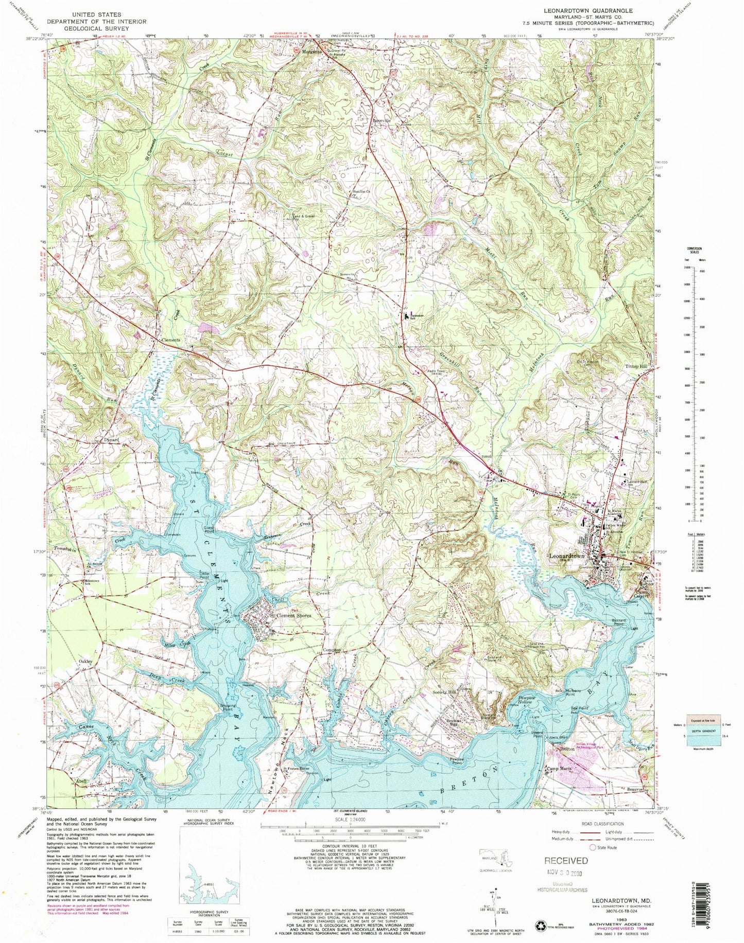
Classic USGS Leonardtown Maryland 7.5'x7.5' Topo Map
Couldn't load pickup availability
Historical USGS topographic quad map of Leonardtown in the state of Maryland. Typical map scale is 1:24,000, but may vary for certain years, if available. Print size: 24" x 27"
This quadrangle is in the following counties: St. Mary's.
The map contains contour lines, roads, rivers, towns, and lakes. Printed on high-quality waterproof paper with UV fade-resistant inks, and shipped rolled.
Contains the following named places: Ledford Farm Pond Dam, Ledford Farm Pond, Rich Neck Creek, Saint Clements Creek, Abell, Abells Wharf, All Saints Church, Benjamin Banneker Elementary School, Beauvue, Breton Bay, Bretons Bay, Britton, Burnt Mill Creek, Buzzard Point, Camp Calvert, Camp Maria, Canoe Neck Creek, Cecil Creek, Cedar Point, Cherry Cove Creek, Clements, Combs Creek, Compton, Deep Creek, Dynard, Dynard Run, Father Andrew White School, Fox Point, Greenhill Run, Guest Point, Leonard Hall Junior Naval Academy, Leonardtown, Locust Run, Lovers Point, Loveville, McIntosh Run, Milestone School, Miley Creek, Miski Run, Moll Dyers Run, Mulberry Point, Nelson Run, Saint Aloysius Parish Cemetery, Oakley, Old Saint Aloysius Cemetery, Pawpaw Hollow, Pawpaw Point, Ryken High School, Saint Aloysius Church, Saint Clement Shores, Saint Francis Xavier Church, Saint Joseph School, Saint Josephs School, Saint Marys Academy, First Saints Community Church Cemetery, Shipping Point, Society Hill, Stauffer Church, Tenneson Creek, Tom Swamp Run, Tomakokin Creek, Town Run, WKIK-AM (Leonardtown), Morris Point, Abell Post Office, All Saints Episcopal Church Cemetery, Barton Hall, Bayside Wharf, Bluff Woods, Burlington, Canoe Neck, Cedar Point Creek, Cobrums Wharf, Collingwood, Fog Hall, Morganza Post Office, Mount Pleasant, Neals Lott, River View, Saint Winifreds (historical), Bayside School (historical), Beauvue Post Office (historical), Breton Bay Country Club, Breton Woods, Burnt Mill, Buzzard Point, Charles Memorial Gardens, Chopticon High School, Clements Post Office, Clements School (historical), Compton Post Office, Fords Enclosure (historical), Foxwell Point, Friendship School (historical), Greenbrier, Holly Oaks, Howard Wharf (historical), Indian Village Archeological Park, Leonardtown Baptist Church, Leonardtown Elementary School, Leonardtown Park, Leonardtown Post Office, Leonardtown Public School (historical), Leonardtown Square Shopping Center, Leonardtown Town Hall, Leonardtown Wharf, Loveville Post Office, Loveville Special Education Center, Maryland Springs School (historical), Newtown (historical), Newton Manor House, Pawpaw Hollow, Saint Clement Shores Park, Saint Francis Xavier Parish Cemetery, Saint Marys County Courthouse, Saint Marys County Government Center, Saint Mary's County Detention Center, MedStar Saint Mary's Hospital, Saint Nicholas Creek, Saint Pauls United Methodist Church, Saint Peters Episcopal Church, Saint Williams Creek, Shamrock Glen Estates, Shanti Medical Center, Stones Wharf, Sunnyside School (historical), Valentine Hall, Saint Marys Nursing Home, District 3 Leonardtown, Leonardtown Volunteer Fire Department Company 1, Maryland State Police - Barrack T Leonardtown, Saint Mary's County Sheriff's Office, Leonardtown Volunteer Rescue Squad Company 19, Mechanicsville Mennonite School, Loveville Mennonite School, Clover Hill Mennonite School, Friendship Mennonite School, Saint Mary's County Evening High School, Saint Mary's County Home and Hospital, College of Southern Maryland Leonardtown Campus, Saint Mary's County Sheriff's Office, Town of Leonardtown, Clements Airport, Recompense Farm Airport, Combs Creek Marina, Leonardtown Wastewater Treatment Plant, Saint Mary's County Library - Leonardtown Branch