MyTopo
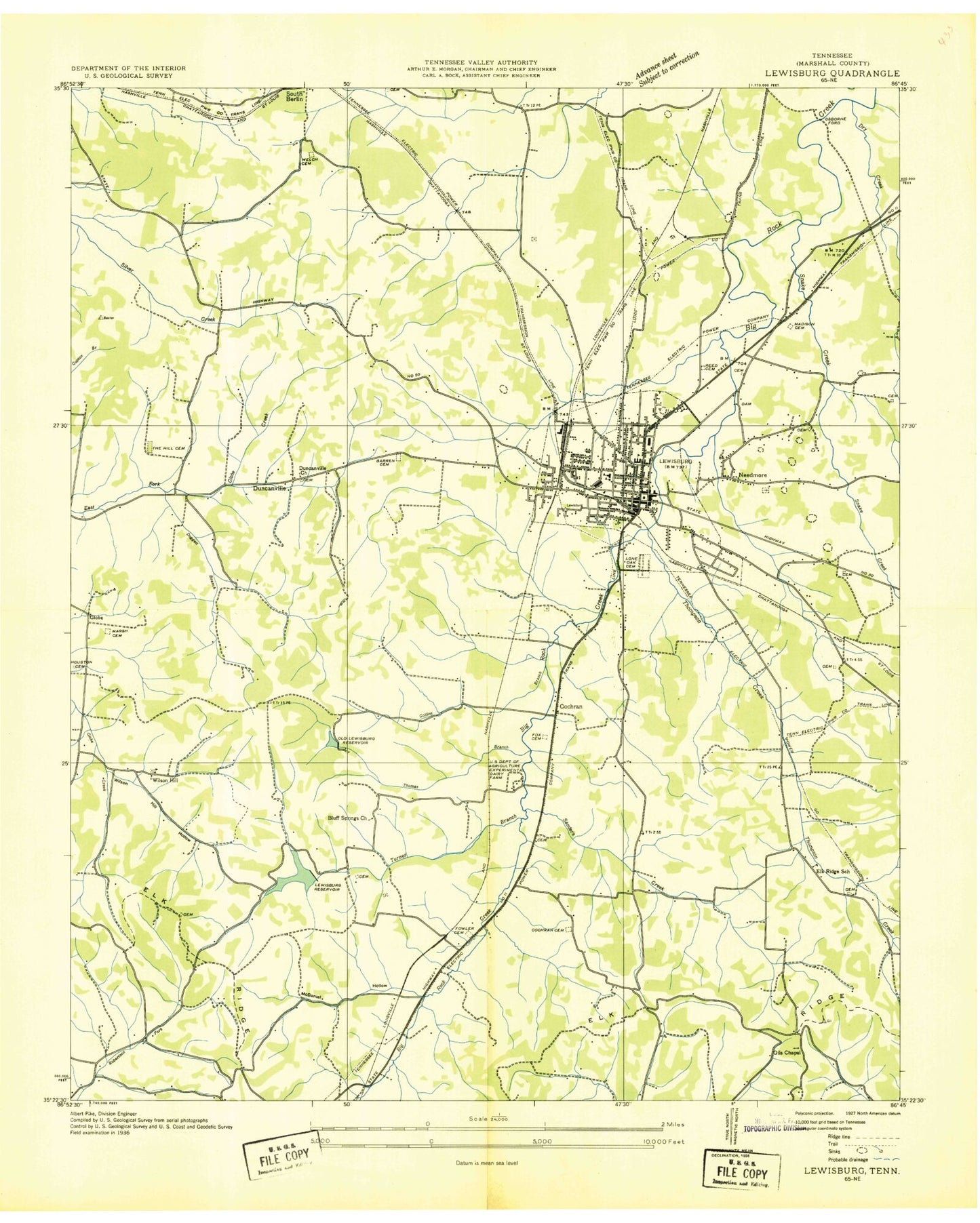
Classic USGS Lewisburg Tennessee 7.5'x7.5' Topo Map
Couldn't load pickup availability
Historical USGS topographic quad map of Lewisburg in the state of Tennessee. Map scale may vary for some years, but is generally around 1:24,000. Print size is approximately 24" x 27"
This quadrangle is in the following counties: Marshall.
The map contains contour lines, roads, rivers, towns, and lakes. Printed on high-quality waterproof paper with UV fade-resistant inks, and shipped rolled.
Contains the following named places: Anderson Cemetery, Anderson Spring, Andrews Spring, Barron Hill, Barron Spring, Baxter Cemetery, Baxter Ridge, Beatty Cemetery, Beck Hollow, Benton, Bluff Springs Church, Bowden Cemetery, Boyet Cemetery, Boyett Cemetery, Cedar Ridge Landfill, Church Street Church of Christ, City of Lewisburg, Cochran, Cochran Cemetery, Coleman Heights, Collins Cemetery, Collins Creek, Collins Hollow, Commissioner District 8, Commissioner District 9, Connelly Junior High School, Cook Memorial Cemetery, Copps Branch, Crawley Ridge, Daugharty Cemetery, Daugharty Gap, Davis Knob, Doggett Branch, Dry Branch, Duncanville, East Commerce Baptist Church, Edwards Cemetery, Elk Ridge, Elk Ridge School, Elliott Cemetery, Endsley Cemetery, Ewing Cemetery, Fairview, First Baptist Church of Fifth Avenue, First Church of the Nazarene, First Presbyterian Church, First United Methodist Church, Forest Hills, Fowler Cemetery, Fox Cemetery, Garrett Cemetery, Gill Chapel, Gills Chapel Cemetery, Gipson Cemetery, Globe, Hardin Cemetery, Hardison Elementary School, Harris Cemetery, Hendrix Cemetery, Hickory Heights, Hickory Heights Church of Christ, Hil-A-Wa Lake, Hill Cemetery, Hillcrest, Hopkins Spring, Hopwood Cemetery, Houston Cemetery, Houston Hollow, Howe Station, Immanuel Church, Isley Cemetery, Jackson Hollow, Jones Field, Jones Training School, Landon Cemetery, Leonard Hospital, Lewisburg, Lewisburg Airport, Lewisburg City Hall, Lewisburg Cumberland Presbyterian Church, Lewisburg Division, Lewisburg Fire Department, Lewisburg Fire Department West Side Station, Lewisburg First Baptist Church, Lewisburg Industrial Park, Lewisburg Police Department, Lewisburg Post Office, Lewisburg Reservoir, Lewisburg Reservoir Dam, Lincoln Park, London Cemetery, Lone Oak Cemetery, Loyd Branch, Marsh Cemetery, Marshall County, Marshall County Courthouse, Marshall County Emergency Medical Service, Marshall County High School, Marshall County Plaza Shopping Center, Marshall County Recreation Center and Golf Club, Marshall County Sheriff's Department, Marshall County Vocational Center, Marshall Heights, Marshall Medical Center, Mc Ateer Cemetery, McCollum Gap, McCord School, McCorkle Cemetery, McDaniel Cemetery, McDaniel Hollow, McLeary Cemetery, Memorial Library, Moore - Davis Cemetery, Mount Carmel Cemetery, Murdock Spring, Myres - Devin - Madison Cemetery, Needmore, New Lake Branch, Old Distillery Spring, Old Marshall Academy Spring, Osborne Ford, Paradise Lake, Parkview Baptist Church, Persimmon Ridge, Pleasant Hill Cemetery, Pleasant Hill Church, Powell Cemetery, Purdon Cemetery, Rambo Cemetery, Rambo Hollow, Reed Cemetery, Rolling Hills, Rone - Cheatham Cemetery, Ross Spring, Saint James Baptist Church, Saint John Church, Sanders Creek, Sanford Fire Brigade Station 1 Headquarters Lewisburg Manufacturing Center, Second Avenue Church of Christ, Sharp Cemetery, Shiloh Cemetery, Snake Creek, Talley Cemetery, Thomas Branch, Thompson Cemetery, Tillmon Cemetery, United State Experimental Dairy Farm, Vickrey Spring, Wallace Acres, WAXO-AM (Lewisburg), Welch Cemetery, White Acres, Whitehead, Wills-Hopwood Cemetery, Wilson Hill, Wilson Hill Hollow, WJJM-AM (Lewisburg), WJJM-FM (Lewisburg), Worley Cemetery, ZIP Code: 37091