
MyTopo
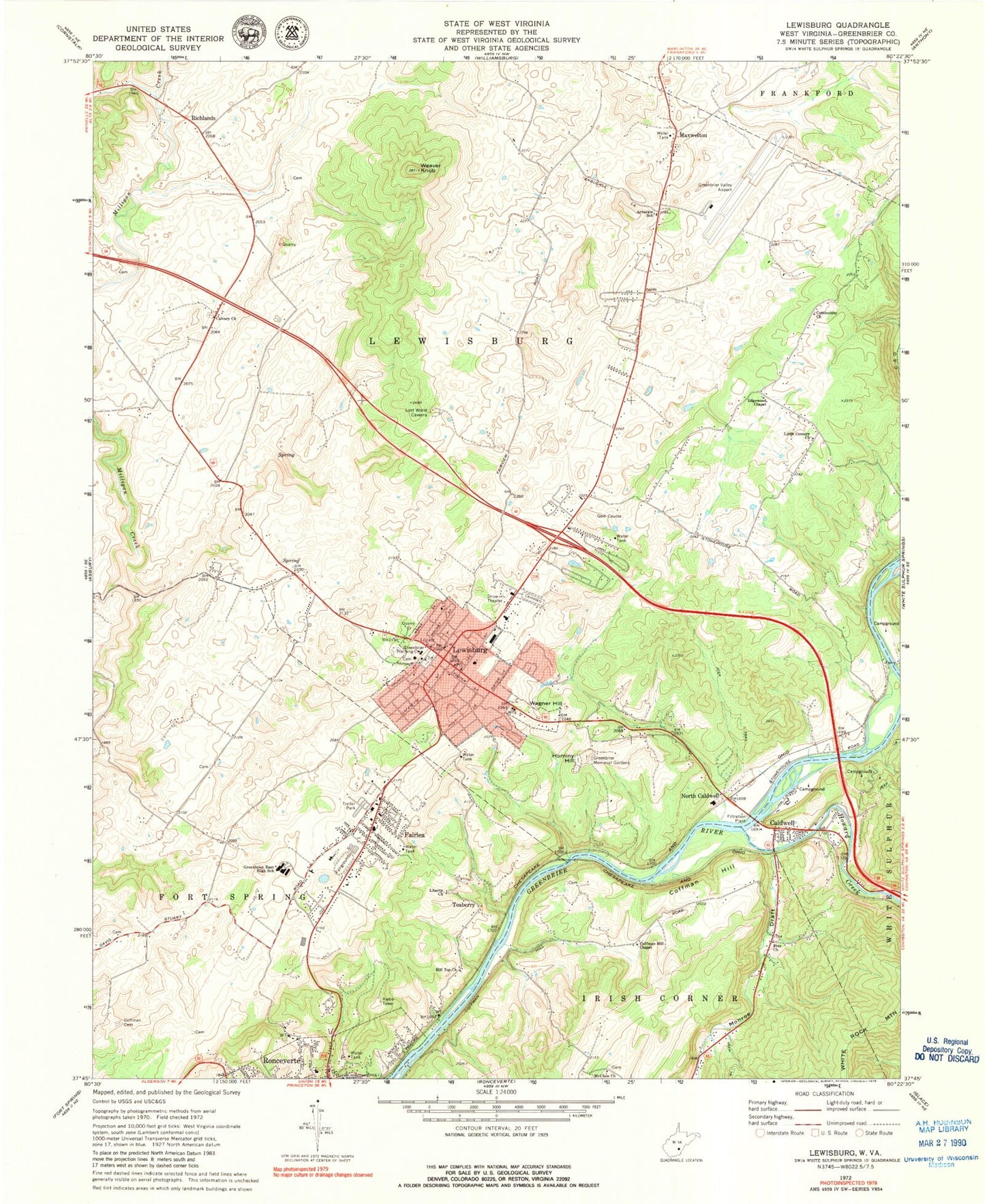
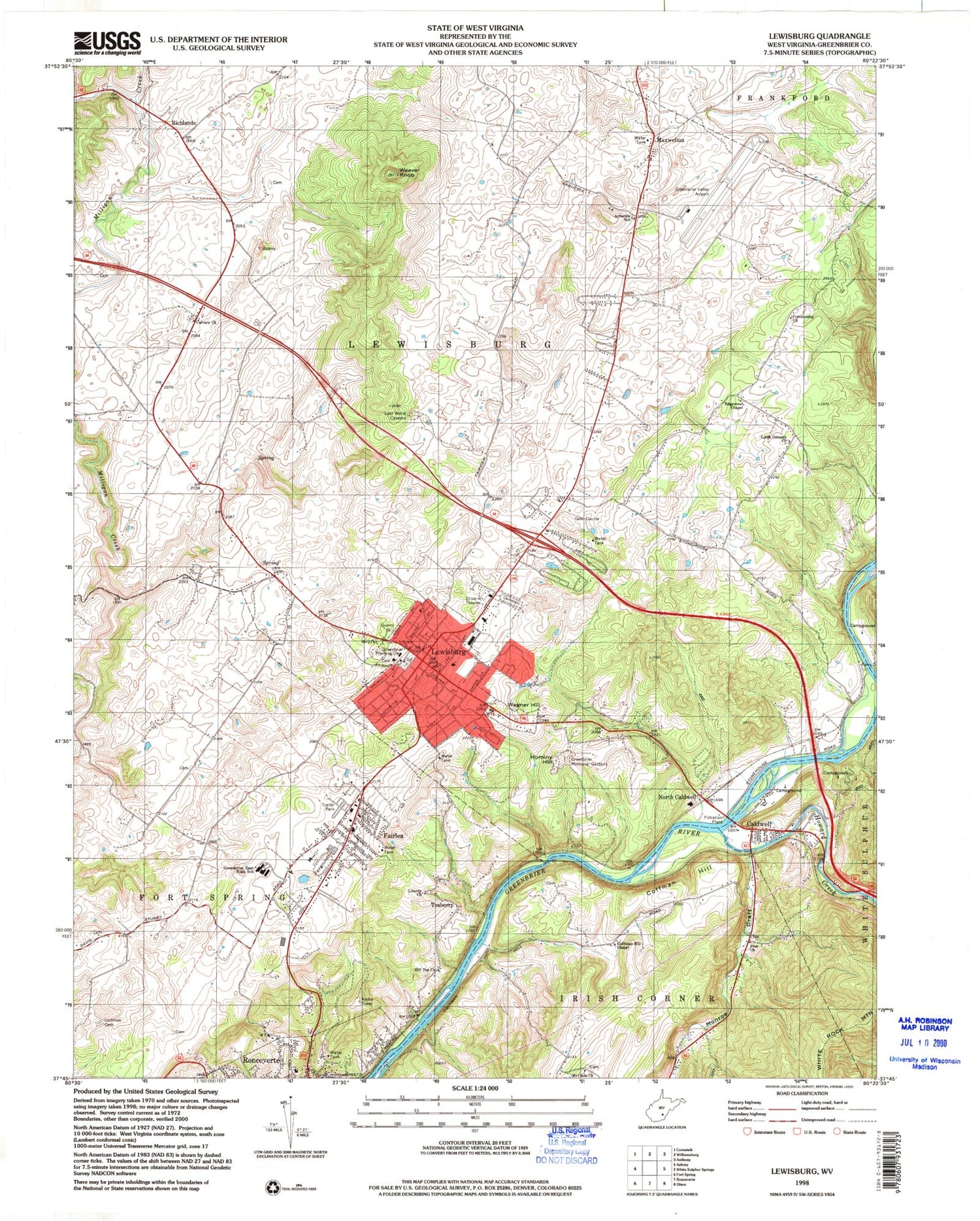
Classic USGS Lewisburg West Virginia 7.5'x7.5' Topo Map
Couldn't load pickup availability
Historical USGS topographic quad map of Lewisburg in the state of West Virginia. Typical map scale is 1:24,000, but may vary for certain years, if available. Print size: 24" x 27"
This quadrangle is in the following counties: Greenbrier.
The map contains contour lines, roads, rivers, towns, and lakes. Printed on high-quality waterproof paper with UV fade-resistant inks, and shipped rolled.
Contains the following named places: Arbuckle School (historical), Calvary United Methodist Church, Coffman Cemetery, Coffman Hill, Coffman Hill Chapel, Community Church, Edgewood Chapel, Free Church, Greenbrier East High School, Greenbrier Memorial Gardens, Hilltop Baptist Church, Lewisburg, Liberty Baptist Church, Little Country Church, McClain Church, Milligan Creek, Monroe Draft, Weaver Knob, North Caldwell, Richlands, Cat Rock Hollow, Howard Creek, Caldwell, Fairlea, Hominy Hill, Maxwelton, Teaberry, Wagner Hill, Balm of Gilead School (historical), Central School (historical), Coalbank School (historical), Edgewood School (historical), Fairview School (historical), George School (historical), Greenbrier Valley School (historical), Holliday School (historical), Holliday-Lewis School (historical), Livesay School (historical), Mathews Ford, Monroe Draft School (historical), Morlunda, Rolling Hills, Rosewood Cemetery, Saint James Episcopal Church, Shuck Memorial Baptist Church, Solomon Springs School (historical), South Church Street Historic District, Underwood Estates, Walnut Hills, West Virginia School of Osteopathic Medicine, Whitcomb (historical), White School (historical), Bowling Elementary School (historical), Bowling High School (historical), Buckingham Acres, Calvary Baptist Church, Cedar Knoll Trailer Park, Church of Christ, Crowfields, Dogwood Heights, Elmhurst, Fair Oaks Trailer Park, Fort Union (historical), Fuller Trailer Park, Greenbrier College for Women (historical), Greenbrier County Courthouse, Greenbrier County Library, Greenbrier Military Academy (historical), Greenbrier Valley Mall Shopping Center, John Weslty United Methodist Church, Lewis Spring, Lewisburg Elementary School, Lewisburg High School (historical), Lewisburg Historic District, Lewisburg United Methodist Church, Maple Street Historic District, Mount Tabor Baptist Church, Mountain View Estates, Old Stone Presbyterian Church, New Covenant Sanctuary Church of God, Red Oaks Shopping Center, Ronceverte Elementary School, Greenbrier Valley Fairground, Johnson Spring, Morlunda Farms Spring, Morlunda Farms Spring, Greenbrier Training Center, Savannah Mills (historical), Old Stone Cemetery, Lewisburg Maternity Hospital (historical), Greenbrier Valley Medical Center, Greenbrier Valley Airport, Pratt Mining Heliport, Lewisburg Post Office, Caldwell Post Office, Maxwelton Post Office, WRON-AM (Ronceverte), Central District, Eastern Greenbrier Middle School, Greenbrier Episcopal School, Fairlea Census Designated Place, City of Lewisburg, City of Ronceverte, Fairlea Volunteer Fire Department, Lewisburg Volunteer Fire Department Headquarters, Lewisburg Volunteer Fire Department Station 1, Lewisburg Volunteer Fire Department Station 2, Greenbrier County Emergency Ambulance, Lewisburg Baptist Acadamy, Lewisburg Elks Country Club Golf Course, Humana Hospital-Greenbrier Valley, Caldwell Bridge, PFC Ralph E Pomeroy Memorial Bridge, Gary Wayne Martini Memorial Bridge, Lewis Theatre, Marquee Cinemas - Seneca Showcase, Trillium Performing Arts Collective, Confederate Cemetery, Lewisburg Police Department, Greenbrier County Sheriffs Office, West Virginia State Police Troop 6 - Lewisburg Detachment