MyTopo
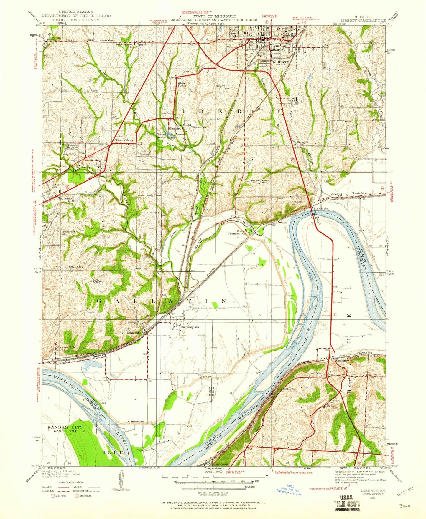
Classic USGS Liberty Missouri 7.5'x7.5' Topo Map
Couldn't load pickup availability
Historical USGS topographic quad map of Liberty in the state of Missouri. Map scale may vary for some years, but is generally around 1:24,000. Print size is approximately 24" x 27"
This quadrangle is in the following counties: Clay, Jackson.
The map contains contour lines, roads, rivers, towns, and lakes. Printed on high-quality waterproof paper with UV fade-resistant inks, and shipped rolled.
Contains the following named places: Alexander Doniphan Elementary School, Arsenal Hill, Barnes Memorial Fountain, Big Blue Bend, Birmingham, Birmingham Levee Unit, Blue River, Brick Monroe School, Brown Hall, Browns Lake, Calvary Church, Cates Branch, Catholic Diocese of Kansas City - Saint Joseph Lake Dam, Cement City, City of Glenaire, City of Liberty, City of Pleasant Valley, City of Sugar Creek, Clay County Sheriff's Office, Claycomo, Claycomo Fire and Rescue, Claycomo Plaza, Clayview Country Club, Courtney, Coventry House, Crossroads West, Crowley Cemetery, Curry Library, Dale Patton School House, Davidson Cemetery, Dd Fellows Home Lake, Del Buffalo Seminary, East Kansas City, Eaton Hall, Ely Hall, Ewing School, Fairview Cemetery, Faith Academy, Federal Transient Camp, Franklin Elementary School, Gano Chapel, Glenaire, Gracemor Christian Church, Gracemor Elementary School, Grand River Chapel, Great Midwest Corporation Dam, Great Midwest Corporation Lake, Great Midwest Lake Dam, Greene Hall, Greene Stadium, Greenwood School, Harry S Truman Bridge, Harvest Church, Helping Hand Farm, Independence-Liberty Bridge, Jewell Hall, Juvenile Justice Center, KCXL-AM (Liberty), KWJC-FM (Liberty), Liberty, Liberty Academy, Liberty Bend, Liberty Bend Bridge, Liberty Commons, Liberty Fire Department Station 1, Liberty Fire Department Station 2, Liberty Island, Liberty Junior High School, Liberty Landing, Liberty Landing Shopping Center, Liberty Middle School, Liberty Oaks Elementary School, Liberty Police Department, Liberty Post Office, Liberty Senior High School, Lillian Schumacher Elementary School, Little Shoal Creek, Mabee Center, Mann Cemetery, Manor Hill Elementary School, Marston Hall, Midwest Worlds of Fun, Mill Creek, Minaville Cemetery, Minaville Post Office, Minneville, Minneville Cemetery, Moment of Truth Bible Church, Moore Lake Dam, Morgan Lake Dam, New Hope Cemetery, Number 168 Reservoir, Number 173 Dam, Number 173 Reservoir, Number 174 Reservoir, Number 175 Reservoir, Number 176 Reservoir, Odd Fellows Home Lake Dam, Old Channel Missouri River, Pence Cemetery, Pentecostal Church, Pillsbury Music Center, Pleasant Valley, Pleasant Valley Early Childhood Center, Pleasant Valley Fire Department, Pleasant Valley Police Department, Pleasant Valley School, Pryor Leadership Development Center, Randolph, Randolph Baptist Church, Ravena Gardens, Ridgeview Elementary School, River Bend, Roger Cemetery, Saint Andrews Church, Saint James School, Saint Raphaels Church, Saint Stephen Church, Shoal Creek, Sissons Bend, South Liberty, South Valley Junior High School, South Valley Middle School, Sugar Creek, Sugar Creek Junction, Tower View Baptist Church, Town Branch, Union Church, Urban Lake, Village of Birmingham, Village of Claycomo, Village of Randolph, Village of River Bend, Virginia Holding Corporation North Lake Dam, Virginia Holding Corporation South Lake Dam, Wayne City Bend, Wayne City Landing, White Hall Fields, White Science Center, William Jewell College, William L Howard Lake, Withers School, Yates-Gill College Union, ZIP Codes: 64158, 64161