MyTopo
Classic USGS Liberty South Carolina 7.5'x7.5' Topo Map
Couldn't load pickup availability
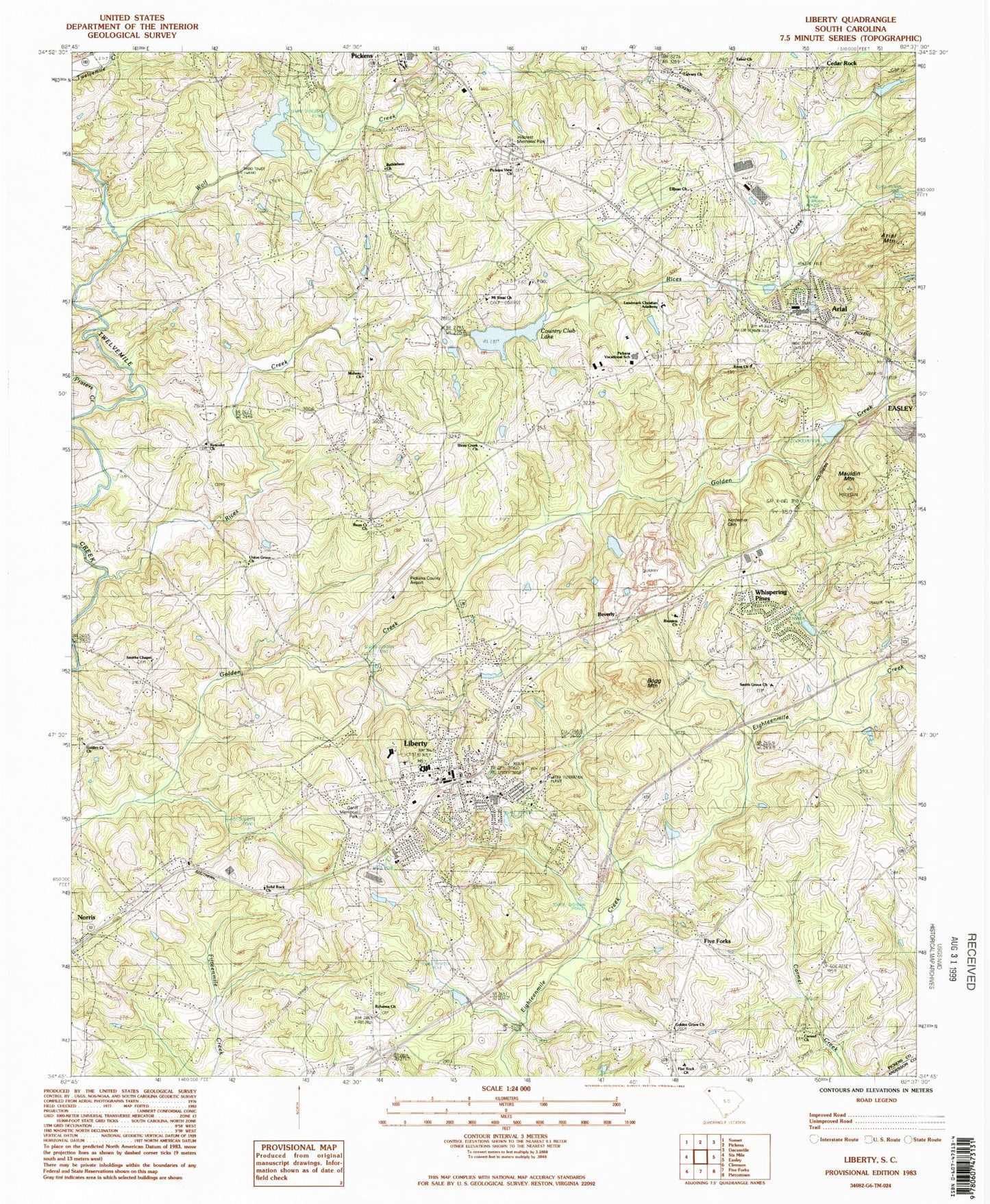
Historical USGS topographic quad map of Liberty in the state of South Carolina. Map scale may vary for some years, but is generally around 1:24,000. Print size is approximately 24" x 27"
This quadrangle is in the following counties: Anderson, Pickens.
The map contains contour lines, roads, rivers, towns, and lakes. Printed on high-quality waterproof paper with UV fade-resistant inks, and shipped rolled.
Contains the following named places: Abbott Cemetery, AnMed Health Cannon Hospital, Apostolic Church of the Lord Jesus, Ariail Hendricks Cemetery, Arial, Arial Baptist Church, Arial Census Designated Place, Arial Church of God, Arial Mountain, Arial United Methodist Church, Bethel Community Church, Bethlehem Roanoke Water District Water Tower, Bethlehem School, Bethlehem United Methodist Church Graveyard, Beverly, Bible Baptist Church, Bogg Mountain, Calumet Baptist Church, Calvary Church, Carmel Church, Carmel Presbyterian Church Graveyard, Cedar Rock, Cedar Rock Church of God, Cedar Rock School, City of Liberty, Clayton Cemetery, Country Club Lake, Cramer Wastewater Treatment Plant, Day Star Baptist Fellowship, East Pickens Baptist Church, Elljean Baptist Church, Enon Baptist Church, Enon Baptist Church Graveyard, First Baptist Church, Five Forks, Flat Rock Baptist Church Graveyard, Flat Rock Church, Flat Rock School, Free Wesleyan Church, Golden Creek Baptist Church, Golden Creek Baptist Church Graveyard, Golden Grove Church, Golden Grove Wesleyan Church Graveyard, Grace Church, Hamby Pond, Hamby Pond Dam D-1944, Hillcrest Memorial Park, Hillwood, Holden Pond, Holden Pond Dam D-1958, Holly Springs School, Holy Cross Catholic Church, Holy Spring School, Hopkins Bridge, Kennemer Cemetery, Landmark Christian Academy, Liberty, Liberty Athletic Complex, Liberty Cemetery, Liberty Church of God, Liberty Colored High School, Liberty Division, Liberty Elementary School, Liberty Family Care Center, Liberty Fire Department, Liberty Fire Department - Station Two, Liberty High School, Liberty High School Football Stadium, Liberty Memorial Gardens, Liberty Middle School, Liberty Police Department, Liberty Post Office, Liberty Presbyterian Church, Liberty Quarry, Liberty Town Hall, Maranatha Baptist Church, Mauldin Mountain, Midway Church, Moons Store, Mount Sinai Baptist Church, New Hope Baptist Church, New Life Independent Baptist Church, Pickens Church of God - Family Life Center, Pickens County Airport, Pickens County Country Club, Pickens County Library - Sarlin Branch Library, Pickens County Sheriff's Office, Pickens Elementary School, Pickens View Church, Pickens View Wesleyan Church Graveyard, Pickens Vocational School, Piney Grove Church, Praters Creek, Restoration Church of Christ of Latterday Saints, Reunion Church, Reunion School, Rices Creek, Rices Creek Baptist Church Graveyard, Rices Creek Church, Roanoke Baptist Church, Roanoke Baptist Church Graveyard, Roanoke School, Robinson Chapel United Methodist Church, Rosewood Heights, Ruhama Church, Ruhamah Baptist Church Graveyard, Seventh Day Adventist Church of Pickens, Shady Grove, Smith Grove Baptist Church, Smith Grove Baptist Church Graveyard, Smiths Chapel, Solid Rock Church, South Carolina Highway Patrol - Troop Three - Pickens County, South Carolina Noname 39010 D-1957 Dam, South Carolina Noname 39027 D-1940 Dam, Southside Water District Water Water Tower, Tabor Church, Tabor United Methodist Church Graveyard, Traber, Tri-City Baptist Church, Twelvemile River Watershed 12 Reservoir, Union Grove Church, Union United Methodist Church, United Wesleyan Church, WELP-AM (Easley), West View Cemetery, Whispering Pines, Wolf Creek, Wolf Creek School, WTBI-AM (Pickens), ZIP Code: 29657