MyTopo
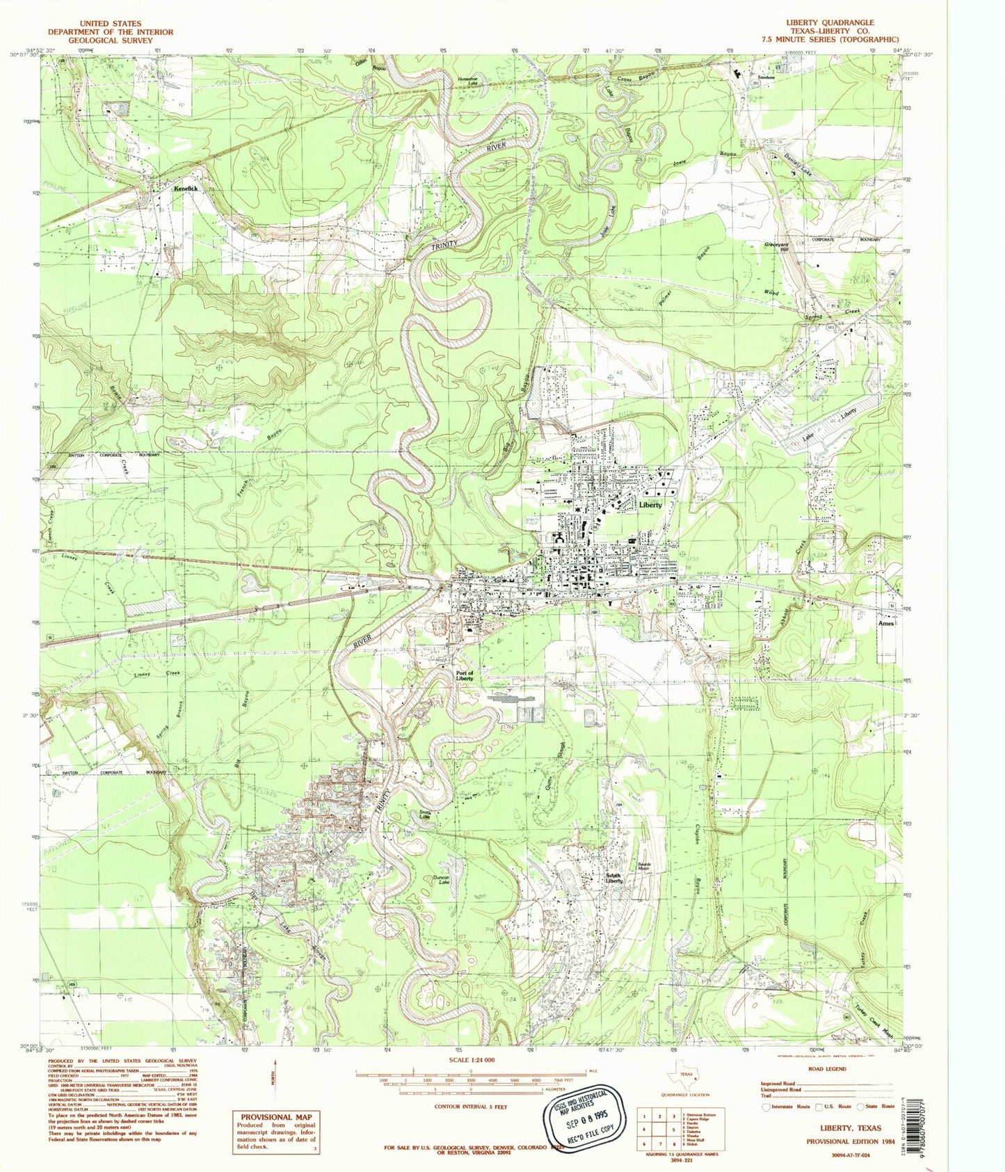
Classic USGS Liberty Texas 7.5'x7.5' Topo Map
Couldn't load pickup availability
Historical USGS topographic quad map of Liberty in the state of Texas. Map scale may vary for some years, but is generally around 1:24,000. Print size is approximately 24" x 27"
This quadrangle is in the following counties: Liberty.
The map contains contour lines, roads, rivers, towns, and lakes. Printed on high-quality waterproof paper with UV fade-resistant inks, and shipped rolled.
Contains the following named places: Abbott Creek, Atascosito, Beards Marsh, Big Bayou, Bowie Creek, Branch Cemetery, Champ d'Asile, City of Liberty, City of Liberty Fire Department, Clayton Bayou, Cleveland-Partlow House, Cross Bayou, Cypress Lake, Daniel Ranch, Daniels Lake, Daniels Lake Dam, Day Lake, Duncan Lake, Fairlawn Cemetery, Fairlawn Memorial Park, First United Methodist Church of Liberty, French Bayou, French Creek, Gillen Bayou, Graveyard Hill, Gulf Coast High School, Gulf Coast High School - Cleveland, Gulf Coast High School - Dayton, Gulf Coast High School - Liberty, Gum Slough, Hardin - Chambers Center, Hardin - Chambers Education Center, Hardin - Chambers Learning Center, Hayes Park, Horse Shoe Bend Bayou, Horseshoe Lake, Immaculate Conception Church, Josie Bayou, Josie Lake, Josie Lake Levee, Kenefick, Kenefick City Hall, Kenefick Police Department, Kenefick Volunteer Fire and Rescue, Kersting Hospital, KPXE-AM (Liberty), Lake Bayou, Lake Liberty, Liberty, Liberty City Hall, Liberty County Constable's Office Precinct 1, Liberty County Courthouse, Liberty County Jail, Liberty County Sheriff's Department - Detective, Liberty County Sheriff's Department - Identification, Liberty County Sheriff's Office, Liberty Dayton Regional Medical Center, Liberty Elementary School, Liberty Fire Department, Liberty High School, Liberty Middle School, Liberty Police Department, Liberty Post Office, Liberty Stadium, Liberty-Dayton Division, Linney Creek, Mill Creek, My Heliport, Negros Liberty Settlement, Neyland Cemetery, North Height Tabernacle, Old Hardin Cemetery, Palmer Bayou, Pleasant Hill Church, Pruett Bayou, Saint Johns Church, Saint Pauls Church, Saint Stephens Episcopal Church, San Jacinto Elementary School, Sandune, Snag Lake, South Liberty, South Liberty Oil Field, Spring Branch, State Highway 3 Bridge, Town of Kenefick, Trinity Valley Baptist Church, Turkey Creek, Turkey Creek Church, Twin Lake, West Liberty High School, Wood Spring Creek