MyTopo
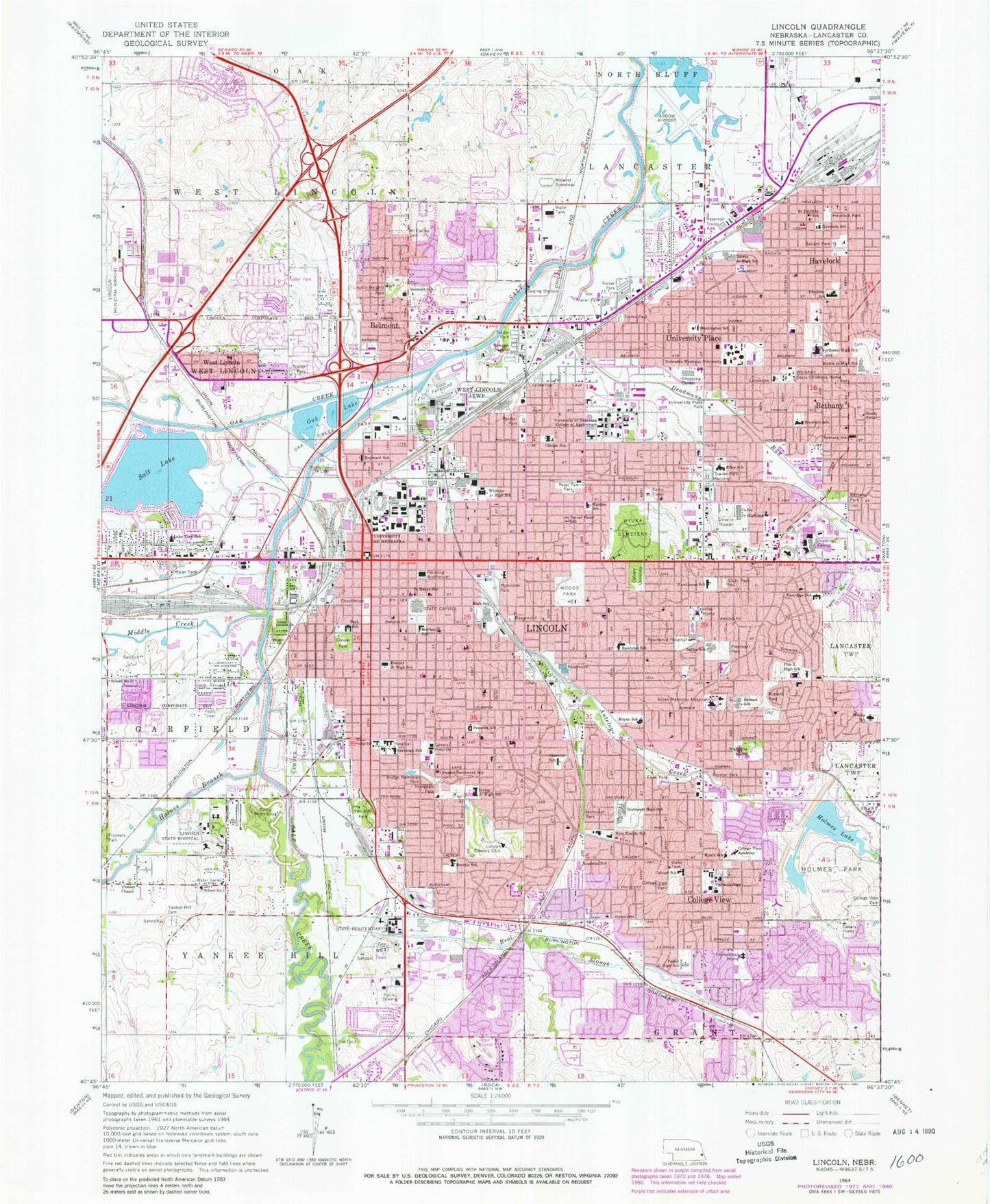
Classic USGS Lincoln Nebraska 7.5'x7.5' Topo Map
Couldn't load pickup availability
Historical USGS topographic quad map of Lincoln in the state of Nebraska. Typical map scale is 1:24,000, but may vary for certain years, if available. Print size: 24" x 27"
This quadrangle is in the following counties: Lancaster.
The map contains contour lines, roads, rivers, towns, and lakes. Printed on high-quality waterproof paper with UV fade-resistant inks, and shipped rolled.
Contains the following named places: Antelope Creek, Holmes Lake, Antelope Park, Ballard Park, Beattie Elementary School, Belmont Elementary School, Bethany, Bethany Park, Bethany School, Blessed Sacrament School, Brownell Elementary School, Bryan Medical Center - East Campus, Bryan Community High School, Calvary Cemetery, Calvert Elementary School, Camp Minis Kuya, Cedars Home, Clinton Elementary School, College View, College View Academy, College View Cemetery, College View Park, Cooper Park, Culler Middle School, Dawes Middle School, Deadmans Run, Eastridge Elementary School, Eden Park, Everett Elementary School, Bryan Medical Center - West Campus, Hartley Elementary School, Havelock, Havelock Park, Havelock School, Bryan Community School High School, Hayward School, Holmes Park, Holmes School, Holy Family School, Homestead Home, Huntington Elementary School, Helen Hyatt Elementary School, Irving Middle School, Irvingdale Park, Lakeview Elementary School, Lefler Middle School, Lincoln Heights Park, Lincoln Regional Center, Madonna Rehabilitation Hospital, McPhee Elementary School, Memorial Park, Mickle Middle School, Middle Creek, Morley Elementary School, Mount Carmel Cemetery, Nebraska Wesleyan University, Normal Park, Lincoln Northeast High School, Oak Creek, Oak Lake, Park Middle School, Pentzer Park, Pershing Elementary School, Peter Pan Park, Piedmont Park, Pioneer Chapel, Pius X High School, Pound Middle School, Prescott Elementary School, Providence Hospital (historical), Randolph Elementary School, Riley Elementary School, Roberts Park, Rousseau Elementary School, Rudge Memorial Park, Sacred Heart School, Saint Marys School, Saint Patricks School, Salt Lake, Saratoga Elementary School, Sawyer Snell Park, Sheridan School, Lincoln Southeast High School, Stuhr Park, Tabitha Home, Taylor Park, Union College, University of Nebraska - Varner Hall, University of Nebraska - Lincoln, University Place, University Place Park, Van Dorn Park, West Lincoln, Whitehall State Childrens Home, Whittier Junior High School, Woods Park, Wyuka Cemetery, Yankee Hill Cemetery, Lancaster County, Haines Branch, Lincoln Country Club, Pershing Auditorium, School Number 3, School Number 51, Nebraska State Capitol, Lincoln, Beal Slough, KLIN-AM (Lincoln), KFOR-AM (Lincoln), KXGH-FM (Lincoln), KFRX-FM (Lincoln), KZUM-FM (Lincoln), KMXA-FM (Lincoln), KRNU-FM (Lincoln), Bryan Memorial Hospital Heliport, Saint Elizabeth Community Health Center Heliport, Lincoln General Hospital Heliport, Holmes Lake-Site 17 Dam, Lincoln, Lincoln Post Office, Hobson, Havelock, Havelock Post Office, Lancaster, Lancaster Post Office (historical), Carling, College View Post Office (historical), Bethany Post Office (historical), Worthington Military Academy (historical), Belmont, University Place Post Office (historical), West Lincoln, West Lincoln Post Office (historical), Saline City (historical), Normal Post Office (historical), MoPac Trail, John Dietrich Bikeway Trail, Antelope Creek Trail, Antelope Park Trail, Billy Wolff Bikeway Trail, Briarhurst-Tierra Trail, Bison Trail, Wilderness Park Trails, Highlands Trail, Max E Roper Park Trail, Highway Two Trail, Old Cheney Road Trail, Rock Island Trail, Salt Creek Trail, Superior Street Trail, Wyuka Trail, Highlands Park, Roper Park, Belmont Park, Oak Creek Park, Hayward Park, Iron Horse Park, Schwartzkopf Park, Fleming Fields, Woodside Park, Idylwild Park, UPCO Park, West Lincoln Park, Willard and Schroeder Park, 40th and Highway 2 Park, Nebraska State Penitentiary, Fire Station Number Eleven, Lincoln Fire and Rescue Station 14, Lincoln Fire and Rescue Station 1 Headquarters, Lincoln Fire and Rescue Station 2, Lincoln Fire and Rescue Station 3, Lincoln Fire and Rescue Station 4, Lincoln Fire and Rescue Station 5, Lincoln Fire and Rescue Station 6, Lincoln Fire and Rescue Station 7, Lincoln Fire and Rescue Station 8, Lincoln Fire and Rescue Station 9, Lincoln Fire and Rescue Station 10, Lincoln Fire and Rescue Station 13, Doris Baer Complex, YMCA Wright Park, Lincoln Police Department, Bennett Martin Public Library, South Branch Library, Anderson Branch Library, Belmont Branch Library, Bethany Branch Library, Gere Branch Library, Abbott Sports Complex, Woodlawn Estates, Gaslight Village, Countryside Estates, Cardiology Clinic, Anis Eye Institute, Ear Nose and Throat Specialties Building, Nebraska Heart Institute, Orchard Park, Homestead Healthcare Center, Consultative Nephrology Peritoneal Dialysis Center, Cotner Chiropractic Center, Elliott Chiropractic Center, Osteoporosis Center of Nebraska, Arthritis Center of Nebraska, Elders Plus Building, Lincoln Pediatric Associates Center, Line-Care Center, Lincoln Chiropractic Center, Great Plains Ear Nose Throat Head and Neck Surgery Institute, Green Chiropractic Center, Womens Clinic of Lincoln, Housecalls Phlebotomy Center, Ambassador Lincoln Center, Mosier-Timperley Chiropractic Clinic, Holmes Lake Manor, Legacy Center, Haven Manor Assisted Living, Community Mental Health Center, Lancaster Manor, Just Like Home, Lincoln Orthopedic and Sports Medicine Clinic, Independence House, Camp-A-Way, Sky View Mobile Home Ranch, State Fair Park Campgrounds, North Bottoms Historical Marker, University of Nebraska Historical Marker, Nebraska Statehood Memorial Historical Marker, Lincolns Founding Block Historical Marker, Lincoln Regional Center Historical Marker, Giant Glacial Boulder Historical Marker, Lewis-Syford House Historical Marker, Ferguson Mansion, Ferguson House Historical Marker, Fairview Historical Marker, Pershing Rifles Historical Marker, County-City Building


