MyTopo
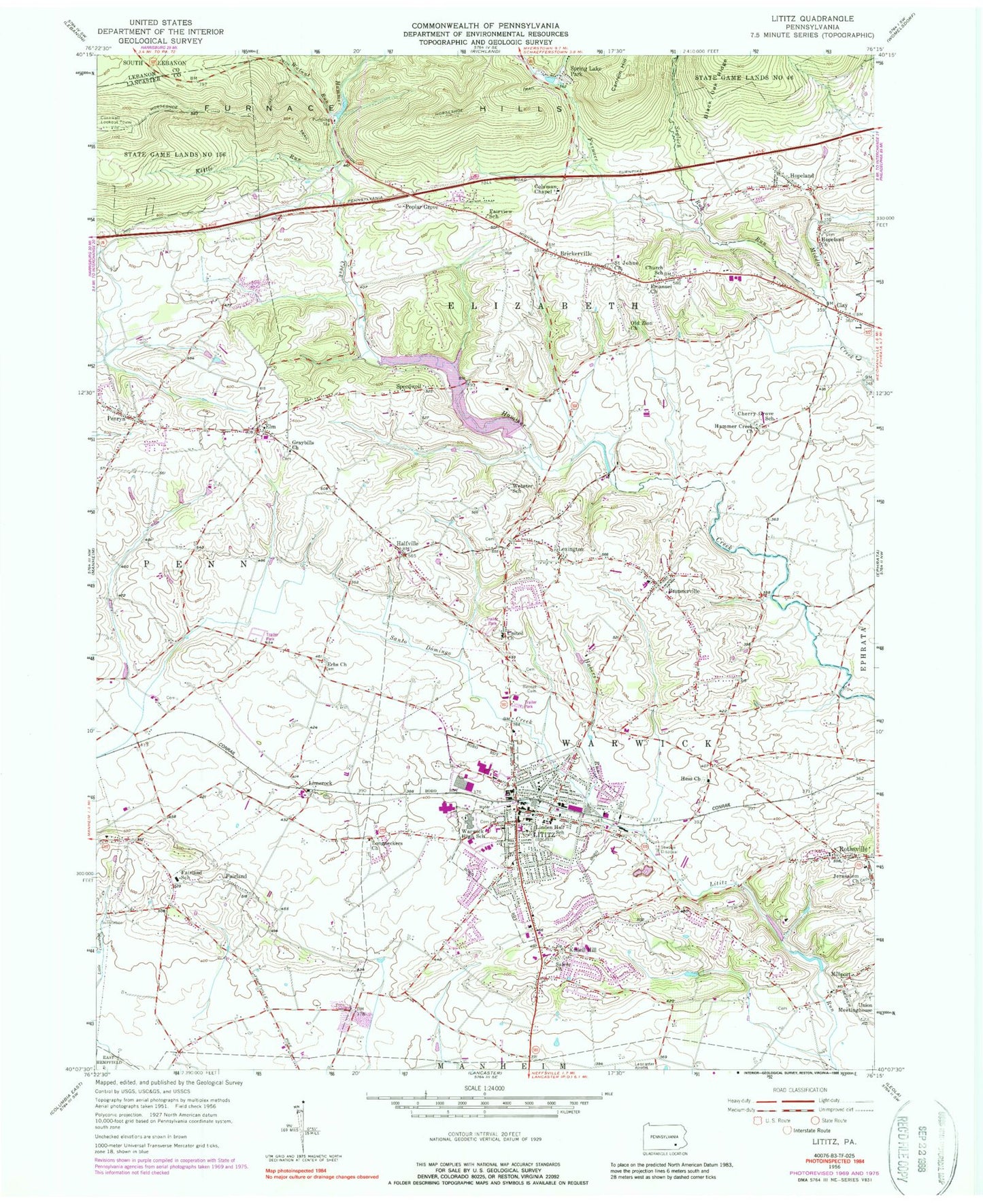
Classic USGS Lititz Pennsylvania 7.5'x7.5' Topo Map
Couldn't load pickup availability
Historical USGS topographic quad map of Lititz in the state of Pennsylvania. Map scale may vary for some years, but is generally around 1:24,000. Print size is approximately 24" x 27"
This quadrangle is in the following counties: Lancaster, Lebanon.
The map contains contour lines, roads, rivers, towns, and lakes. Printed on high-quality waterproof paper with UV fade-resistant inks, and shipped rolled.
Contains the following named places: Airy Hill Farm, Becker Graveyard, Bomberger Cemetery, Borough of Lititz, Brickerville, Brickerville Census Designated Place, Brickerville Fire Company Station 21, Brickerville Post Office, Brickerville United Lutheran Church and Cemetery, Brubaker - Bar Cemetery, Brubaker Cemetery, Brunersville Post Office, Brunnerville, Brunnerville Fire Company Station 22, Brunnerville United Methodist Cemetery, Burkholder Grave Yard, Cannon Hill, Cherry Grove School, Church School, Clay, Clayview Farms, Coleman Chapel, Cornwall Lookout Tower, Danda Farms, Doe Run Elementary School, Eagle Rock, Eby Cemetery, Elm, Elm Post Office, Emanuel Church, Erb Cemetery, Erb Mennonite Church Cemetery, Erbs Church, Fairland, Fairland Elementary School, Fairview School, Furnace Run, Graybill Church of the Brethren Cemetery, Graybills Church, Grebiel / Seemuller Graveyard, Halfville, Hammer Creek Church, Hammer Creek Mennonite Church Cemetery, Hammer Creek Old Order Amish Cemetery, Heart of Lancaster Regional Medical Center, Hershey Cemetery, Hess Church, Hess Family Cemetery, Hess Mennonite Cemetery, Hoffer Gravesite, Hopeland, Hopeland Cemetery, Hopeland Census Designated Place, Hopeland Church, Hopeland Post Office, Huber Graveyard Number 2, Hubers Run, Keller Graveyard, Kettle Run, King Farm, Kissel Hill Cemetery, Kissel Hill Elementary School, Kissell Hill, Kreider Family Cemetery, Lexington, Lexington - Kauffman Cemetery, Lime Rock Mennonite Church Cemetery, Limerock, Linden Hall School, Lions Club Park, Lititz, Lititz Borough Police Department, Lititz Carrier Annex Post Office, Lititz Church of the Brethren Memorial Garden, Lititz Elementary School, Lititz Fire Company 1 Station 25, Lititz Post Office, Lititz Spring, Lititz Springs Park, Locust Street Park, Longenecker Church of the Brethren Cemetery, Longneckers Church, Lutz Graveyard, Machpelah Cemetery, Millport, Millport Mennonite Church Cemetery, Moravian Cemetery, Netzly Graveyard, New Evangelical Cemetery, New Haven, New Haven Mennonite Cemetery, New Haven Run, Old Zion Church, Penn Post Office, Penryn, Penryn Cemetery, Penryn Census Designated Place, Penryn Fire Company 1 Station 28, Penryn Post Office, Philip Roth Cemetery, Pine Hill Cemetery, Poplar Grove, Revolutionary War Memorial, Ric Rac Farms, Rohrers Quarry, Rome, Rothsville, Rothsville Lutheran Cemetery, Rothsville Post Office, Rudy Cemetery, Saint James Graveyard, Saint Johns Church, Saint Johns Lutheran Cemetery, Salem Church, Salem Evangelical Lutheran Church Cemetery, Santo Domingo Creek, Segloch Run, Shenk Airport, Speedwell, Speedwell Forge Dam, Spring Lake, Spring Lake Park, State Game Lands Number 46, Stauffer Graveyard, Steinmetz Cemetery, Temple Beth El Cemetery, Township of Elizabeth, Township of Penn, Township of Warwick, Trinity Evangelical Congregational Church Cemetery, Union Mettinghouse, United Church, United Zion Home Cemetery, Walnut Run, Warner-Lambert Heliport, Warwick, Warwick Community Ambulance Station 85, Warwick High School, Warwick Middle School, Webster School, White Oak Church of the Brethren Cemetery, Witness Park Cemetery, Woodridge Swim Club, Zion German Reformed Church Cemetery, Zug Family Cemetery, ZIP Code: 17543