MyTopo
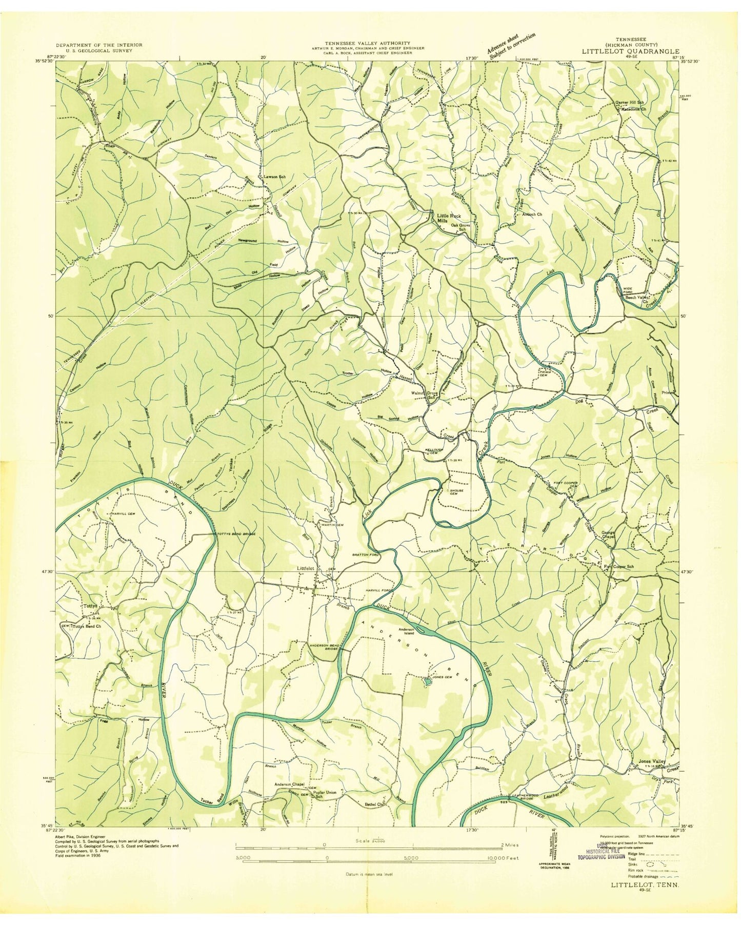
Classic USGS Littlelot Tennessee 7.5'x7.5' Topo Map
Couldn't load pickup availability
Historical USGS topographic quad map of Littlelot in the state of Tennessee. Map scale may vary for some years, but is generally around 1:24,000. Print size is approximately 24" x 27"
This quadrangle is in the following counties: Hickman.
The map contains contour lines, roads, rivers, towns, and lakes. Printed on high-quality waterproof paper with UV fade-resistant inks, and shipped rolled.
Contains the following named places: Allen Cemetery, Alum Cave Hollow, Anderson Bend, Anderson Bend Bridge, Anderson Bend Church, Anderson Bend Mine, Anderson Chapel, Anderson Hollow, Anderson Island, Antioch Church, Ash Hollow, Beale, Beale Cemetery, Beech Valley Church, Betsobe Branch, Big Spring Hollow, Bird Hollow, Blue Hole Bluff, Bluff Point, Bluffpoint, Boot Branch, Bratton Ford, Bratton Ford Bridge, Buck Branch, Burnham Branch, Campbell Hill, Cannon Hollow, Capps Hollow, Cates Hollow, Cavender Branch, Chaney Hollow, Cheairs Cemetery, Cisco Hollow, Coleman Branch, Coleman Branch Mine, Commissary Hollow, Commissioner District 5, Cooper Hollow, Darden Cemetery, Dial Branch, Dog Creek, Dogwood Flat, Dry Prong Leatherwood Creek, Fielder Hollow, Fogg, Fogg Hollow, Fogg Hollow Mines, Fort Cooper Cemetery, Fort Cooper Creek, Fort Cooper School, Foster Ridge, Garner Hill, Garner Hill School, Gee Ford Bridge, Gee Hill, George Chapel, Gerry Branch, Gin Branch, Grace Branch, Ham Branch, Harrill Ford, Harrington Branch, Harvill Cemetery, Hassell Creek, Hemlock Hollow, Hilltop Church, Hooper Hollow, Hooper Spring, Hutchinson Spring Branch, Jack Branch, Jones Cemetery, Jones Creek, Jones Hollow, Jones Valley, Kellough Cemetery, Lawson School, Leatherwood Bridge, Leatherwood Creek, Lick Creek, Little Lot School, Little Rock Mills, Littlelot, Littlelot Division, Litton Cemetery, M C West Tailings Pond, M C West Tailings Pond Dam, Macedonia Church, Martin Cemetery, Mayberry Hollow, McAdoo Branch, McFarland Cemetery, McFarland Hollow, Meadows Mine, Mill Branch, Mossy Shoal Branch, Mount Pisgah School, Mount Pleasant Cemetery, Mount Pleasant Church, Mud Branch, Murphy Hollow, Neely Branch, New Antioch Church, New Bethel Church, Newground Hollow, Oak Grove School, Oklahoma Branch, Old Field Hollow, Panther Branch, Peter Cave Hollow, Pine Bluff, Pipe Ridge, Poplar Union School, Possum Hollow, Primm Cemetery, Primm Springs, Reaves Hollow, Red Dirt Hollow, Rockhouse Hollow, Rocky Hollow, Russell Branch, Sanders Branch, Shop Hollow, Short Creek, Shouse Cemetery, Simms Hollow, Slaughter Hollow, Smith Bend, Smithson Branch, Stairsteps Hollow, Steep Hollow, Stevens Hollow, Stillhouse Branch, Stillhouse Hollow, Sugar Creek, Sugarcamp Hollow, Tatum Creek, Tottys Bend, Tottys Bend Bridge, Tottys Bend Church, Tottys Bend Mines, Tucker Bend, Tucker Branch, Tyler Ridge, Walnut Grove School, Warren Hollow, Waters Branch, Waters Branch Prospects, Webb Branch, Webb Spring, Wet Prong Leatherwood Creek, Wide Ford, Wide Ford Bridge, Williams Cemetery, Williams Hollow, Willie Branch, Willow Thicket Hollow, Worley Cemetery, Worley Mine, Yankee Ridge, Yellow Hole Island, ZIP Code: 37098