MyTopo
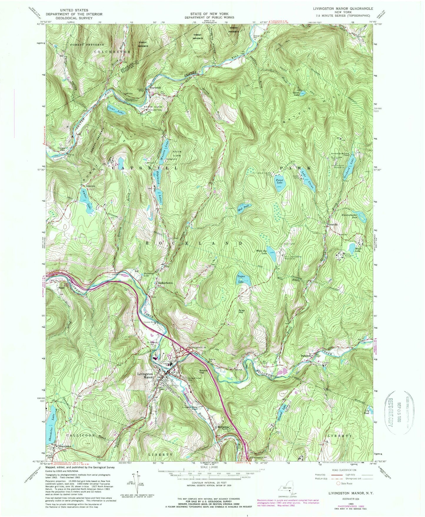
Classic USGS Livingston Manor New York 7.5'x7.5' Topo Map
Couldn't load pickup availability
Historical USGS topographic quad map of Livingston Manor in the state of New York. Typical map scale is 1:24,000, but may vary for certain years, if available. Print size: 24" x 27"
This quadrangle is in the following counties: Delaware, Sullivan.
The map contains contour lines, roads, rivers, towns, and lakes. Printed on high-quality waterproof paper with UV fade-resistant inks, and shipped rolled.
Contains the following named places: Acadia Camp, Agudas Achim Cemetery, All Souls Chapel, Amber Lake, Bascom Brook, Beaverkill, Beaverkill Campground, Beaverkill Valley Church, Berry Brook, Camp Raleigh, Cattail Brook, Livingston Manor Elementary School, Clear Lake, Craigie Clair, Deckertown, Edgewood Lakes, Elm Hollow, Forest Lake, Gee Brook, Gray Hill, Grooville, Hazel, Hendrickson Memorial Chapel, Hi-Li International Boys Camp, Huggins Hollow, Jersey Brook, Knickerbocker Pond, Little Beaver Kill, Livingston Manor, Maple Lake, Mine Brook, Morsston, Mud Pond, Nimrod Lake, Onteora Scout Reservoir, Orchard Lake, Orchard Street Cemetery, Our Lady of Lourdes Camp, Paradise Lake, Parkston, Pelnor Hollow, Quick Lake, Rattle Hill, Round Top, Saint Aloysius Cemetery, Saint Aloysius School, Shandelee Brook, Shandelee Lake, Sprague Brook, Trojan Lake, Lake Uncas, Voorhees Brook, Waneta Lake, Burnt Hill, Hazel Brook, Shandelee, White Roe Lake, Lincoln Farm Lake, Joscelyn, Town of Rockland, Beaverkill Covered Bridge, Livingston Manor Census Designated Place, Van Tran Flat Bridge, Livingston Manor Post Office, Craigie Clair Road Bridge, Livingston Manor Rest Area, Livingston Manor Free Library, Livingston Manor High School, Livingston Manor Fire Department, Volunteer Ambulance Corps of Livingston Manor