MyTopo
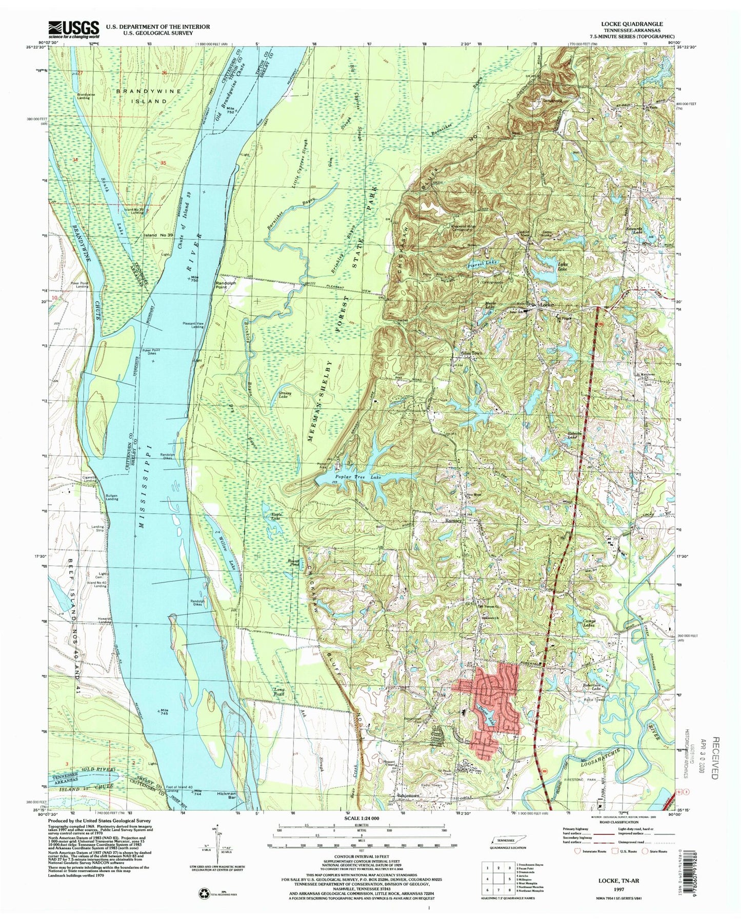
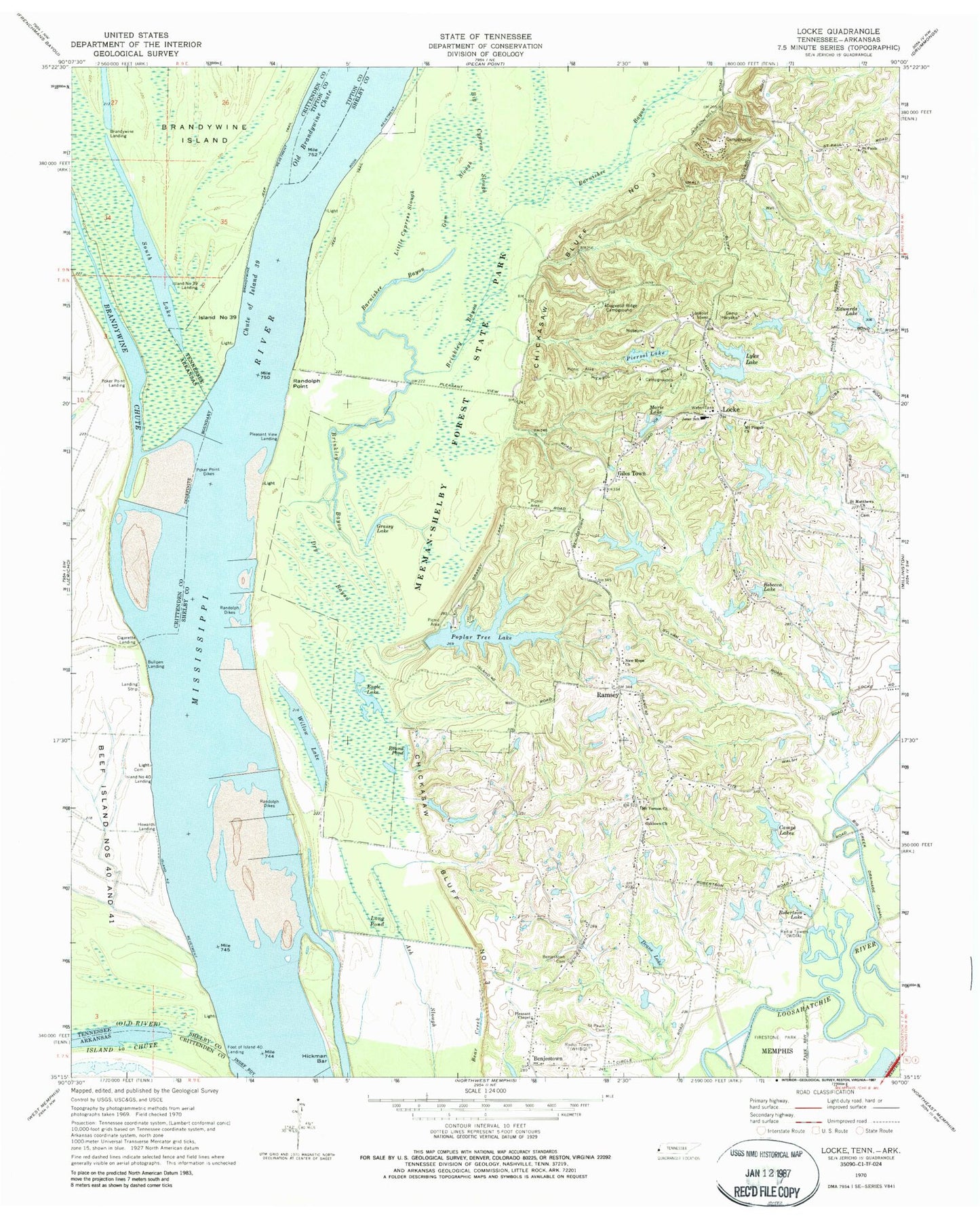
Classic USGS Locke Tennessee 7.5'x7.5' Topo Map
Couldn't load pickup availability
Historical USGS topographic quad map of Locke in the states of Tennessee, Arkansas. Typical map scale is 1:24,000, but may vary for certain years, if available. Print size: 24" x 27"
This quadrangle is in the following counties: Crittenden, Shelby.
The map contains contour lines, roads, rivers, towns, and lakes. Printed on high-quality waterproof paper with UV fade-resistant inks, and shipped rolled.
Contains the following named places: Willow Lake, Pleasant Chapel Missionary Church Cemetery, Big Creek, Big Cypress Slough, Brinkley Bayou, Camp Haiyaka, Camps Lakes, Chute of Island Thirty-nine, Dogwood Ridge Campground, Drane Lake, Dry Bayou, Eagle Lake, Too Lazy To Farm Lake, Grassy Lake, Gum Slough, Hickman Bar, Island Number Thirty-nine, Little Cypress Slough, Locke, Long Pond, Lyles Lake, Marie Lake, Mount Pisgah Church, New Hope Church, Old Brandywine Chute, Piersol Lake, Poker Point Dikes, Ramsey, Randolph Point, Rebecca Lake, Robertson Lake, Round Pond, Robertson Lake Dam, Camp Lake Number One Dam, Camp Lake Number One, McAlexander Lake Number One Dam, McAlexander Lake Number One, Chase Lake Number Three Dam, Chase Lake Number Three, Chase Lake Number One Dam, Chase Lake Number One, Chase Lake Number Two, Chase Lake Number Two Dam, Marie Lake Dam, Lyle Lake, Lyle Dam, Piersol Lake, Piersol Lake Dam, Camp Haiyaka Lake, Camp Haiyaka Dam, Barnishee Bayou, Benjestown, Giles Town, Meeman-Shelby Forest State Park, Mount Vernon Church, Oaklawn Church, Pleasant Chapel, Poplar Tree Lake, Randolph Dikes, Saint Matthews Church, Saint Pauls Cemetery, Saint Pauls Church, Poplar Tree Lake Dam, Too Lazy To Farm Dam, Randolph Point Bar, Shelby Forest Revetment, Northaven, Bateman Point, Jester (historical), Chickasaw Bluff Number Three, Bullpen Landing, Foot of Island Forty Landing, Howards Landing, Island Number Forty Landing, Pleasant View Landing, Saint Matthews Missionary Baptist Church Cemetery, Saint Paul Cemetery, Saint Paul Church (historical), Saint Paul School (historical), Shelby Forest Baptist Church Cemetery, Mount Vernon United Methodist Church Cemetery, Benjestown School (historical), Easthams Landing (historical), Elliots Landing, Island Forty Cemetery, WHBQ-AM (Memphis), WDIA-AM (Memphis), Oaklawn, E E Jeter Elementary School, Shelby Forest Division (historical), Forestview Church of Christ, Grace Community Church, Northaven Elementary School, New Testament Gospel Christian Church, Shoemaker-Shelby Forest Airport, Shelby County Fire Department Station 67, Island 40 Chute, Poker Point Dikes, Brandywine Landing, Cigarette Landing, Poker Point Landing, Poker Point, South Lake, Brandywine Revetment, Island Number 39 Landing