MyTopo
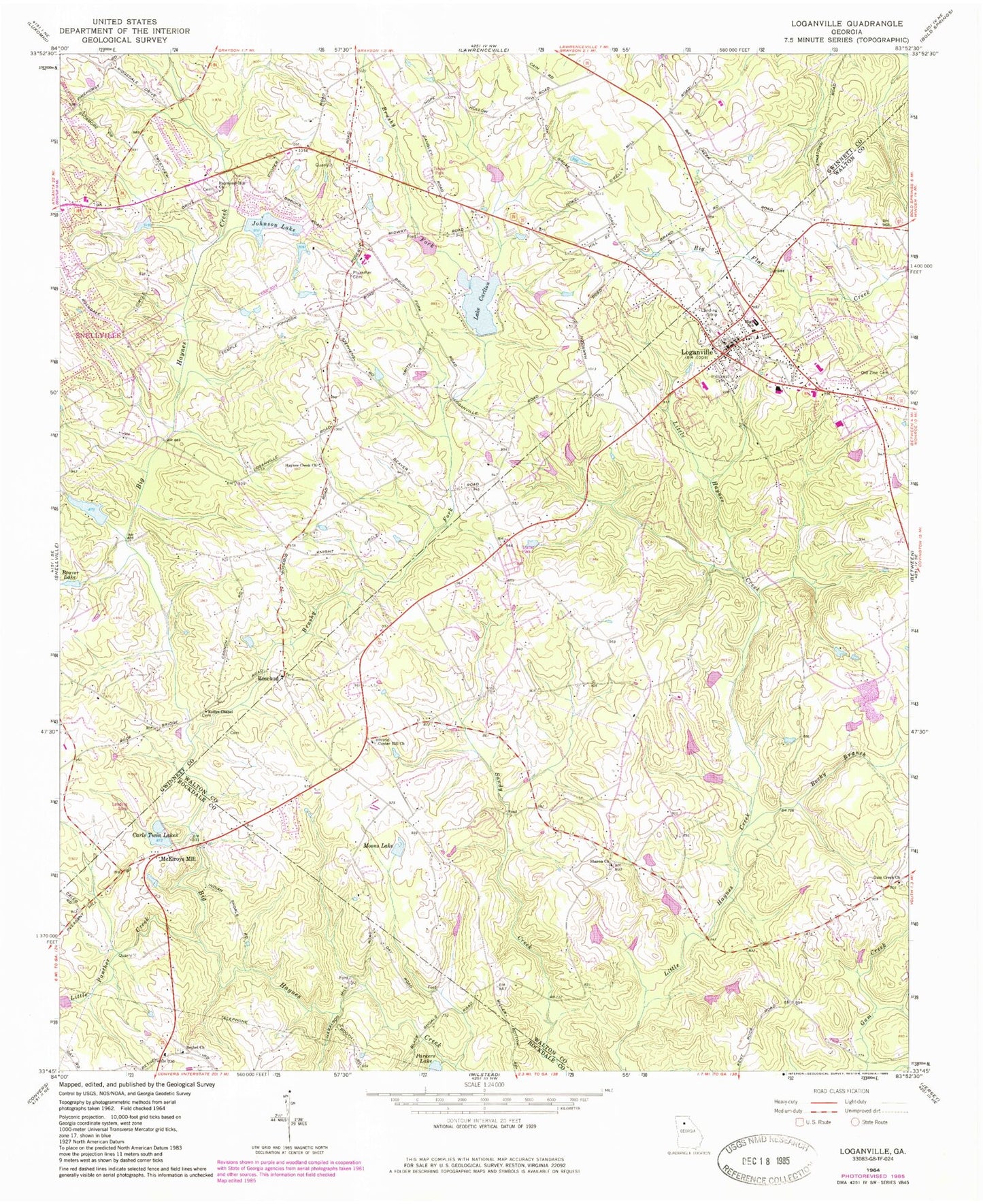
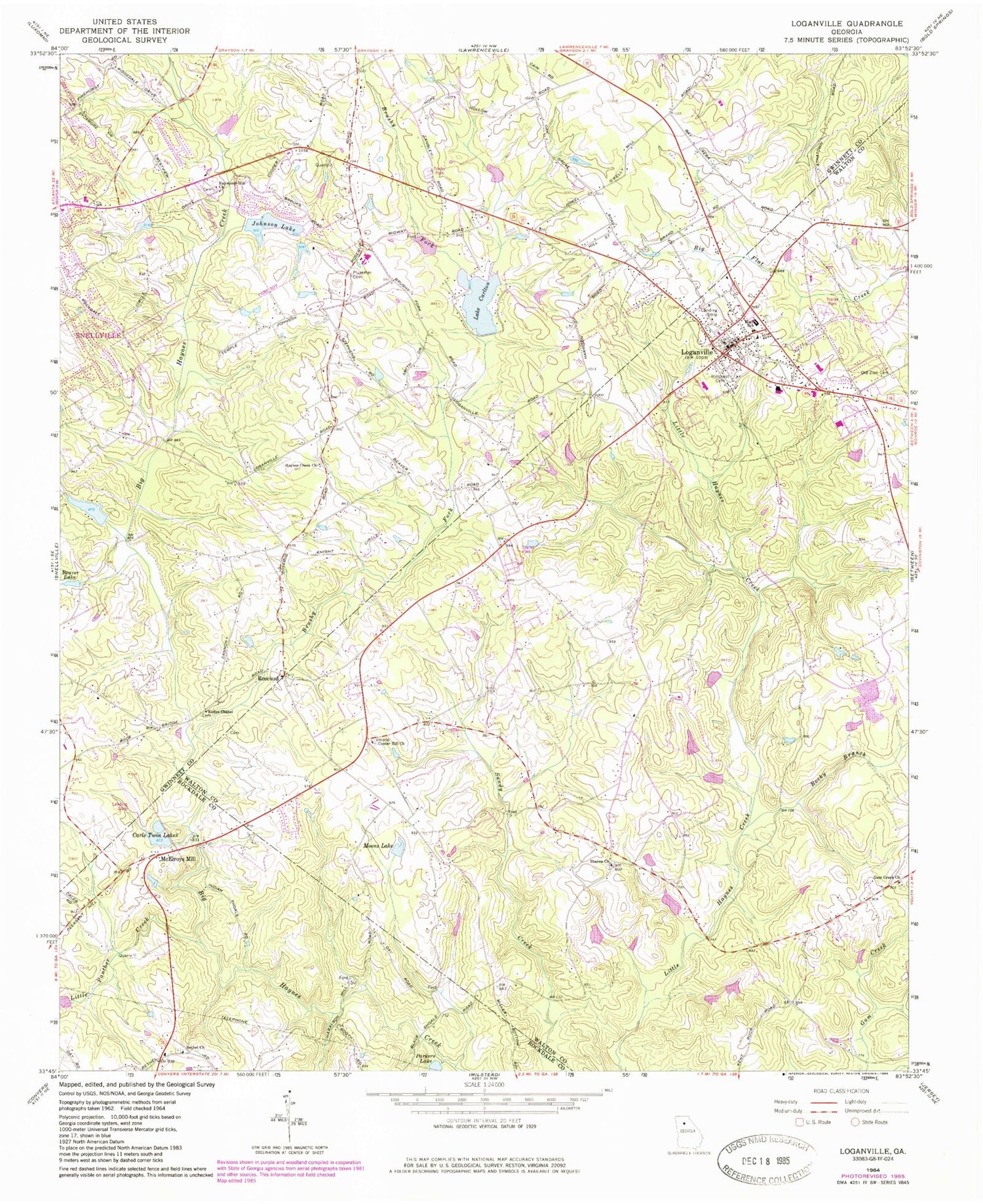
Classic USGS Loganville Georgia 7.5'x7.5' Topo Map
Couldn't load pickup availability
Historical USGS topographic quad map of Loganville in the state of Georgia. Map scale may vary for some years, but is generally around 1:24,000. Print size is approximately 24" x 27"
This quadrangle is in the following counties: Gwinnett, Rockdale, Walton.
The map contains contour lines, roads, rivers, towns, and lakes. Printed on high-quality waterproof paper with UV fade-resistant inks, and shipped rolled.
Contains the following named places: Abington Park, Amatriain Lake, Amatriain Lake Dam, Anderson Lake, Anderson Lake Dam, Anderson Lake Dam III, Anderson Lake III, Bay Creek Elementary School, Bay Creek Middle School, Beaver Lake, Bethel Church, Black Shoals, Brooks Lake, Brushy Fork, Brushy Fork Business Center, Bushy Haynes Creek Watershed Structure Number 21 Dam, Carls Twin Lakes, Carls Twin Lakes Dam, Center Hill Church, City of Loganville, Compton Woods, Covenant Christian Academy, Dew Dam 25, Dew Lake, Falcon Ridge, Grayson High School, Gum Creek Church, Gwinnett County Fire and Emergency Services Station 28, Haralson Mill, Harbour Oaks Montessori School, Haynes Creek Church, Henderson Dam, Henderson Lake, Hickman Dam, Hickman Lake, Hillcrest Cemetery, Indian Shoals, Integrity Christian Academy, J C Magill Elementary School, Johnson Lake, Johnson Lake Dam, Kellys Chapel, Lake Carlton, Lake Carlton Dam, Lenora Airport, Lighthouse Christian Academy, Lighthouse Church, Little Panther Creek, Livsey Corners Shopping Center, Loganville, Loganville Chamber of Commerce, Loganville City Hall, Loganville Elementary School, Loganville Fire Station, Loganville Fire Station 15, Loganville Junior High School, Loganville Middle School, Loganville Plaza Shopping Center, Loganville Post Office, Loganville Primary School, McElroys Mill, Moons Lake, O'Kelly Memorial Library, Old Zion Cemetery, Overlook Point, Plummer Cemetery, Raymond Hill Church, Rock Hill School, Rocky Branch, Rose Garden, Rosebud, Rosebud Commons Shopping Center, Rosebud Elementary School, Rosebud Park, Saddle Club Estates, Saint Oliver Plunkett Church, Sharon Church, Sharon Elementary School, Sharon School, Snellville-Grayson Division, Summit Chase, Summit Chase Golf and Country Club, Sunny Acres, The Station, Trip Elementary School, Tuggle Dam 22, Tuggle Lake, Vines Botanical Gardens, Walkers Park, WALR-FM (Athens), Walton County Fire Rescue Department Station 13, Walton Tabernacle, Whispering Pines Airport, Willow Wind, ZIP Code: 30052